August 28, 2009

Feds to consider protections for Sonoran desert tortoise

A female Sonoran Desert tortoise at the Arizona-Sonora Desert Museum. (File photo by A. E. Araiza/Arizona Daily Star 2008)

By Felicia Fonseca
The Associated Press
Arizona Daily Star


Tucson, Arizona -- The federal government has agreed to consider whether the Sonoran desert tortoise, a Southwest icon whose population has declined by half in the past 20 years, warrants protection under the Endangered Species Act.

Two environmental groups petitioned the U.S. Fish and Wildlife Service to list the tortoise, found in southwest Arizona and northern Mexico, as a distinct population. The agency said Friday it would review the status of the tortoise and any threats to its habitat.

“We expect that the service’s detailed scientific review will show that listing is required to conserve these icons of the desert Southwest,” said Michael Connor of the Western Watersheds Project, which along with WildEarth Guardians filed the petition.

The tortoise is among 13 species and plants that environmentalists sought protection for with a series of petitions filed last fall as part of their “Western Ark” project.

Lawsuits followed in many of the cases for the species, whose ranges span more than a dozen states and stretch into Mexico and Canada. The latest was filed in Texas this week over six freshwater mussels found in the U.S. southeast.

Nicole Rosmarino of WildEarth Guardians said the group has received a number of positive findings as a result of the petitions and subsequent lawsuits. Those include federal wildlife officials’ decision to study the Jemez Mountain salamander, an elusive white-sided jackrabbit and the tortoise.

“With today’s finding, the tortoise has drawn even with the hare in the race to avoid extinction,” she said.

Since taking office, President Barack Obama has distanced himself from several Bush administration policies on the environment and vowed to help restore science at the Interior Department on issues including endangered species.

“We appreciate that, and we think that the Fish and Wildlife Service is doing a very good job of looking at the science, in really examining a whole suite of assaults that are facing this dwindling tortoise,” Rosmarino said.

Environmentalists estimate the tortoise’s population has fallen by 3.5 percent each year — a total of 51 percent — since 1987, but their exact number is unknown. The estimate is based on a sampling of tortoises in Arizona.

Wildlife officials said the environmentalists’ petition presented substantial information that might warrant listing the species as threatened or endangered. Threats include urban sprawl, off-road vehicle use and livestock grazing. The tortoises’ range includes 8.4 million acres of federal public land in Arizona. Livestock grazing is permitted on more than half that land.

The tortoise also is a popular pet, although Arizona Fish and Wildlife prohibits taking them from the desert or returning them because of concerns over the spread of disease or how it could affect genetics. Jeff Humphrey, a spokesman for the Arizona Fish and Wildlife Service, noted that during the 1950s and 60s, some gasoline stations gave away a desert tortoise with every fill-up. He said tens of thousands of desert tortoises call someone’s backyard home.

The Sonoran population lives mostly on rocky hillsides and take cover for much of the year. They are different from their flatland Mojave cousins found west of the Colorado River, which have been federally protected since 1989, Humphrey said.

Environmentalists, believing some of the Mojave population crossed the river at some point, petitioned the federal government to protect those found in the Black Mountains of northern Arizona as well.

A decision on the listing will follow a 12-month review. Since half of the range of the Sonoran tortoise is in Mexico, where the desert tortoise is listed as threatened, Humphrey said “we’re especially keen” to receiving information on their status there.

August 27, 2009

Joshuas in peril


Are Joshua trees facing extinction?

STORY AND PHOTOS BY CHRIS CLARKE
Special to the Victor Valley Daily Press


SUNSET: The setting sun shines on the Joshua tree forest on Cima Dome in the Mojave National Preserve. (CHRIS CLARKE Special to the Daily Press)

The emblematic tree of the Mojave Desert is in big trouble. At a February 2009 climate-change symposium in Joshua Tree sponsored by the National Parks Conservation Association, scientists spoke with gallows humor about the eventual need for Joshua Tree National Park to change its name. The way things are going, it looks as if there will be no Joshua trees left in the park before too many more decades go by.

In a recent study, U.S. Geological Survey scientists Kenneth Cole and his colleagues used climate change models to predict the effects of global warming on the Joshua tree. Cole’s team calculated the likelihood of tree survival and the rate at which the trees reproduce and spread, and mapped the species’ likely range late in this century. The resulting map was empty. Only when the team tweaked their models to assume that the trees disperse their seeds 10 times as efficiently as they actually do, did the model predict Joshua trees would still exist in the wild in the late 21st century.

Even in Cole’s optimistic scenario, the Joshua tree would become extinct in Arizona and Utah. No Joshua trees would survive in JTNP, nor in the Mojave National Preserve. The species would be forced into the northernmost part of its range in eastern California and central Nevada. And all the web of life that depends on the trees elsewhere would unravel.

Take the yucca moth, for instance. The welfare of the Joshua tree depends utterly on the welfare of this inconspicuous insect. The moths and the Joshuas have evolved a remarkable partnership without which neither could reproduce. The moths visit male yucca flowers and gather pollen. They then pollinate and lay eggs in the female blossoms. The eggs hatch and the moth larvae eat some of the developing seeds. Adult moths emerge from the ground when the trees bloom, the timing due to unknown triggers. If changes in spring temperatures prompt moths to emerge when Joshua trees have no open blooms, then both species could suffer catastrophic reproductive failure.

Other desert animals play a role in the Joshua trees’ fate as well. In 2001, rangers observed large missing patches of the bark-like layer on trees throughout JTNP. The next year less than an inch of rain fell in the park. Researcher Todd Esque and his colleagues found that jackrabbits, ground squirrels and pocket gophers, struggling to obtain food in a year when many desert plants failed to germinate or put out new growth, were stripping bark off the trees. Of those trees that had been stripped of even a little bark, very few survived. By 2003 there were no areas of JTNP in which Joshua trees did not exhibit damage. Thousands of the park’s trees died.

Drought interferes with the production of new trees as well. In order to bloom, Joshua trees require significant precipitation in mid-winter, preferably in February. Drought inhibits bloom. Fewer flowers mean fewer seeds and thus fewer baby Joshua trees.

The recent increase in desert wildfires is another climate-related change. Torrential storms have prompted flushes of plant growth throughout the desert, which then provide fuel for dry-season fires. Invasive plants such as red brome grass and Sahara mustard have spread throughout the deserts, increasing fuel loads and filling in bare soil between shrubs that had been a natural firebreak. Before the invasives, lightning could strike a Joshua tree and that tree could burn without the fire spreading. Now fires threaten whole forests of Joshua trees, especially in JTNP.

Joshua trees are damaged directly by fire, with even minor damage often resulting in mortality. They remain standing for years afterward, hellish forests of white-trunked trees with black leaves, like a photonegative of their live counterparts. But if the direct damage done to Joshua trees by fire is devastating, the indirect damage fires do is even worse. Wildfires destroy slow-growing shrubs and facilitate their replacement with grasses. Blackbrush, an important understory plant in most Joshua tree forests, seems not to re-establish at all after wildfires. This is a serious long-term problem for Joshua trees. Joshua seeds that germinate under blackbrush are more likely to escape being eaten by rabbits until they are older and less palatable. Wiping out the blackbrush understory of a Joshua tree forest nearly guarantees that no new trees grow there. And invasive plants fill in where the blackbrush doesn’t, ensuring more frequent future fires.

Migrating trees

Many other trees face threats from climate change, but for most of them the outlook is not nearly as dire. Though individual trees may succumb, if their seeds get dispersed to more habitable locations — as a Clark’s nutcracker might do with whitebark pine seeds, for instance — the species has a chance to survive. But Joshua trees aren’t very good at seed dispersal. Pack rats will carry seeds up to 50 feet from the parent tree, and a few other birds and rodents play a role in moving Joshua tree seeds around. Unless the tree is on a long, steep hill, its seeds don’t move more than a few meters from the parent tree. The seeds have none of the adaptations found in other desert plants to enable wind or animals to carry them long distances: no sticky burrs, no sweet pulp surrounding a gut-proof seed coat, nothing but a delicate little black flake. Usually when something eats a Joshua tree fruit, it kills the seed. It’s very likely that the trees evolved to be dispersed by the Shasta giant ground sloth, which lived throughout the region until about 12,000 years ago, wandering long distances after gorging itself on Joshua tree fruit. Now that the ground sloth is extinct, Joshua trees disperse their seed much less effectively.

There are mature Joshua trees a hundred miles north of their current range. But little is known of what conditions Joshua tree moths can withstand. Some researchers suggest planting Joshua trees in habitats more likely to be hospitable to the trees’ survival. But until we learn more about the needs of the moths, we have no way to know whether those new forests would be able to sustain themselves.

Chris Clarke is a California environmental journalist and natural history writer, whose work can be seen at http://faultline.org. He has been studying Joshua trees since the mid-1990. This piece was adapted from an Educational Bulletin of the Desert Protective Council in San Diego. The full report is available at http://dpcinc.org.

August 23, 2009

Please, don't feed the burros

Too many treats harm animals, official says


By HEATHER SMATHERS
Mohave Daily News


LOVED TO DEATH? Oatman's burros have long been a draw for visitors, but now the BLM is asking people to stop feeding them because it is affecting the animals' health. (HEATHER SMATHERS/The Daily News)

OATMAN - Give burros care, not carrots.

That's one of many draft slogans the Bureau of Land Management has issued, asking people to stop feeding the Oatman burros.

“The Oatman burros have been fed so much they are sick and fat,” said BLM Public Affairs Officer Mike Brown. “They're being loved to death.”

The BLM is asking Oatman shopkeepers, residents and tourists to stop feeding the wild burros carrots, hay pellets, salt cubes and even water.

“Frankly, the wild burros that live around Oatman are far healthier than the burros that come to town,” Brown said.

Burros can get all the nutrients and sustenance they need from the vegetation in the desert areas around Oatman, Brown added.

With thousands of tourists buying bags of carrots and hay pellets to feed to the burros, Brown said the burros are sick from hoof disease, behavior problems and are extremely overweight.

“One carrot won't harm the burros,” Brown said. “But it's the 10,000 more they are being fed every year that will kill them.”

Judy Love, who owns and operates the Classy Ass, said the health of the burros is her main concern.

“I love Oatman and I love the burros, but their health is the most important thing,” Love said. “I'm glad they (BLM) are taking a stand.”

The Oatman burros are more likely to become ill and to die early than the 300 or so wild burros that stay out of town, Brown said.

Brown said the burros will not suffer from any kind of delirium or other illness if they can not have carrots and hay pellets.

“We've seen this before where we cut off the burros and the only side effect is that they get healthier,” Brown said.

But some Oatman shopkeepers dispute that.

“They are getting aggressive because they are not being fed like they used to,” said John Nowak, owner of the Oatman General Store.

Shopkeeper Jolene Brown, who owns Amargosa Toads, agreed, saying that the burros have practically been “kicking her door in” to get food.

All of the burros are managed by the BLM's Wildhorse and Burro Program, legislation that passed Congress in 1971. All wild horses and burros are under the jurisdiction of the Secretary of the Interior and the BLM is responsible for keeping statistics on their numbers, health and safety.

Brown said the BLM has held several town-hall style meetings with the residents and shopkeepers of Oatman. BLM suggested a committee be formed to examine the way the town and the federal government could work together for the well-being of the burros.

“What came out of those meetings is that the townspeople asked the BLM to take the lead and give them guidelines,” Brown said.

What the BLM came up with was an indefinite moratorium on feeding the burros. Shopkeepers have been asked to stop selling carrots and pellets in their stores and to post signs asking tourists not to feed the burros any carrots or other treats they may have brought with them.

Brown said he would not speculate on any possible sanctions shopownwers or tourists would face if they don't comply with the request.

“First, we want to work with people and see what happens. Again, everyone has the same love of the burros and we all have their health in mind,” he said.

Nowak said just because shops will no longer sell carrots doesn't mean people will stop feeding the burros other types of food.

“Part of my shop is a grocery store and I see people buying cookies and potato chips for the burros,” he said. “Is the BLM going to ticket people for feeding them other foods, or food they brought to town?”

He also wondered if the BLM or another agency had the authority to tell stores that they couldn't sell carrots.

“I don't think there is any way to limit our sales of carrots,” he opined.

Jolene Brown said she believes not being able to sell carrots will have an impact on some businesses and the Oatman economy in general.

“I think some businesses, who do a lot of carrot sales, will have to close,” she said.

Changing a culture of many generations of tourists to Oatman won't be easy, Mike Brown acknowledged.

“Think about when the National Park Service asked people to stop feeding the bears at Yellowstone,” he said. “It didn't happen overnight, but people eventually stopped doing it.”

Love said she does not believe the burros will stop coming to town.

“I've been here 21 years, and burros wandered through town before we started feeding them carrots,” she said. “They are wild animals and they will continue to go where they please.”

The BLM's Brown agreed that the burros will still come to town to greet visitors.

“This will not affect Oatman,” Brown said. “People will still come to Oatman to see the burros, just not to feed the burros. People can still come and take pictures, go to the gunfights and shop in the stores.”

But Jolene Brown said she thinks the moratorium will affect Oatman merchants in a negative way.

“The burros are the only reason people come to Oatman,” she said. “Without the burros it's just an old town that sells a bunch of items people can get anywhere.”

August 16, 2009

Follow sun into desert for richest source of solar power

Opinion - California Forum - The Conversation

By Joseph Romm
Sacramento Bee


Sen. Dianne Feinstein appears to like deserts so much that she wants them to stretch from Oklahoma to California and cover one-third of the planet. Nineteen companies have submitted applications to build solar or wind facilities in the Mojave Desert, but Feinstein has said that these renewable energy plants would violate the spirit of what conservationists intended when they donated much of the land to the public.

I am sympathetic to "conservationists," but mostly to those who are trying to conserve what matters most, a livable climate. The solar resource is the only one capable of sustaining the nation's and world's population, even if we all become far, far more efficient.

The good news is that concentrated solar thermal power is such an efficient converter of the sun's energy that we could generate half the country's power with a 65-mile by 65-mile square grid in the Southwest. The bad news is that the obvious place to put much of this generation is the Mojave Desert.

Deserts are certainly fragile, inhospitable ecosystems – a key reason that nobody should want them spreading over one-third of the planet or the entire U.S. Southwest for 1,000 years .

Feinstein said the lands in question were donated or purchased with the intent that they would be protected forever. But the Bureau of Land Management considers the land now open to all types of development, except mining. That policy led the state to consider large swaths of the land for future renewable energy production.

I have little doubt that the solar resource can be tapped in a way that can preserve the desert tortoise, but I have no doubt whatsoever that failing to take advantage of the massive solar resource in the California desert – and in deserts around the country and around the planet – will wipe out a large fraction of the species on this planet.

Joseph Romm is a senior fellow at the Center for American Progress, a liberal think tank, and editor of the weblog ClimateProgress.org

August 13, 2009

Plotting the path of renewable power lines


David R. Baker
San Francisco Chronicle


A new state report tries to tackle one of the touchiest issues in California's effort to expand renewable power, suggesting possible routes for new transmission lines to carry electricity from wind farms and solar plants.

Power lines often generate intense opposition from environmentalists and landowners. But without new lines, the solar power plants and wind farms planned throughout California won't be able to ship their electricity to the towns and cities that need it.

So several state agencies, electrical utilities, renewable power developers and environmental groups have joined together to figure out where to put new lines, hoping to prevent public fights. The effort, called the Renewable Energy Transmission Initiative, released its latest report this week.

The report examines where transmission lines are needed most, will cost the least and will cause the least harm to the environment. It doesn't recommend exact routes, nor does it specify how many lines must be built.

Instead, it presents options, suggesting broad pathways for lines that can link planned renewable power projects to the grid. Most of the proposed lines are in the Southern California desert, while one stretches to the Oregon border.

In concept at least, two lines would run through eastern Contra Costa and Alameda counties, while another would link Tracy to the South Bay. Building all the lines would cost $15.7 billion, but not all of them would need to be built.

"It gives us a sense, based on the environmental input and the economic input, where we should be concentrating our efforts," said Jeffrey Byron, a member of the California Energy Commission, one of the state agencies involved. "We want to utilize existing wires and right-of-ways first, but we do know we're going to need new transmission lines."

Environment, economy

The initiative won't prevent all power-line battles, participants say. But it does attempt to strike a balance between environmental and economic concerns in a way that could become a model for the rest of the country. President Obama has made upgrading and expanding the country's electrical grid a key part of his energy plans.

"We're transforming the way we power the economy. That's an audacious thing to do," said Carl Zichella, regional director for the Sierra Club, who is working on the transmission initiative. "And there are some people whose point of view is limited to their backyards. I think they have a valid point of view, but they don't get a veto."

The report uses as its starting point Gov. Arnold Schwarzenegger's goal of getting 33 percent of California's electricity from renewable sources by the year 2020. It identifies places where large solar power plants, geothermal plants or wind farms have already been proposed, as well as areas where they are likely to be proposed in the future.

Together, those places could generate as much as 77,526 megawatts of electricity, more than all of California uses on a typical summer day. A megawatt is a snapshot figure, representing the amount of electricity flowing across the grid in an instant, and 1 megawatt is enough to power 750 homes.

Obstacles to transmission

The report examines possible routes for transmission lines to carry all that electricity. It also illustrates some of the obstacles. For example, Sen. Dianne Feinstein, D-Calif., has proposed creating a national monument in the Southern California desert that would overlap some of the renewable energy zones studied in the report.

If created, the Mojave Desert National Monument could block the development of 11,700 megawatts of renewable power, according to the report.

August 12, 2009

Water dispensaries keep mountain bighorn sheep alive

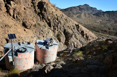
The Kerr Drinker. George Sutton peers into one of the two 1,600-gallon water collection tanks in the Old Dad Range of the Mojave National Preserve, which are filled by members of the Society for the Conservation of Bighorn Sheep. The group spends hours each month maintaining and repairing the tanks for sheep in the summer. (Mark Zaleski/The Press-Enterprise)

By JANET ZIMMERMAN
The Press-Enterprise


A herd of desert bighorn sheep deftly scramble up a rocky hillside in the Mojave National Preserve as the rumble of approaching trucks breaks the silence.

The pickups, each hauling plastic tanks filled with water, come to a stop in a cloud of dust. Soon, the drivers stretch fire hoses from the truck to two big holding tanks that feed a manmade watering hole -- a lifeline for the bighorn and other wildlife that lay claim to this inhospitable landscape.

There are 72 "drinkers" built and maintained across the desert from Interstate 10 north to Death Valley by volunteers with the Society for the Conservation of Bighorn Sheep. The group is a mix of conservationists and hunters whose efforts started 50 years ago when the founders began helping the struggling sheep population.

The work has grown more critical in recent years, they say, as desert springs dry up from drought and from a dropping water table as supplies are siphoned away by development in outlying areas.

"The sheep live on these drinkers from June to September," said Gary Thomas, 70, of Upland, who monitors and fills the watering holes. "Ideally, they would be naturally replenished (with rainfall), but that hasn't happened."

And so the group has resorted to trucking in water during summer months when the moist, green vegetation that sustains bighorn the rest of the year dries up.

In extreme cases, members pay for helicopters to haul water to the most remote locations and have hand-carried water in five-gallon bottles to areas where vehicle access is prohibited. Earlier this summer, the Forest Service donated use of its chopper to ferry supplies and sheep society members nine miles into an inaccessible area of the Santa Rosa Mountains south of Palm Springs to rebuild a drinker.

Threats to desert bighorn go beyond water shortages, however.

The elusive animals historically have been compromised by disease, hunting, habitat loss, competition with livestock and fragmentation of their ranges by fences, highways and canals that cut off wildlife passages between mountains, said Conrad Jones, a wildlife biologist and desert water coordinator for the state Department of Fish and Game.

Conservationists fear the onslaught of alternative energy developments that they say will denude the land and further impede the animals' movement.

The sheep need to travel between ranges and other herds to prevent in-breeding, keeping the animals more resilient to environmental extremes.

Dwindling rainfall is a concern. A 2004 UC Berkeley study found that rain levels have decreased about 20 percent in the Southwest during the past century and cited predictions that precipitation will drop another 10 to 20 percent by 2100. In that case, fewer lambs would survive because of less vegetation, the researchers found.

Desert bighorn in the peninsular ranges -- the Santa Rosa and San Jacinto mountains and Anza-Borrego Desert State Park -- are on the federal endangered species list. The isolated populations there plummeted from an estimated 1,170 in 1971 to about 230 when it was listed in 1998; now there are about 800, said Jane Hendron, spokeswoman for the U.S. Fish and Wildlife Service office in Carlsbad.

In all, an estimated 3,500 to 5,500 desert bighorn sheep live in California, up from fewer than 2,000 in the 1960s and '70s, Thomas said.

"Now we have a viable population," he said. "That's directly related to building big-game drinkers."

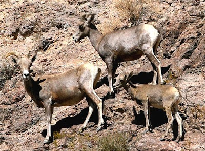
Bighorn sheep watch as members of the Society for the Conservation of Bighorn Sheep drive water to the Kerr Drinker at the Old Dad Mountain range in the Mojave National Preserve. (Mark Zaleski/The Press-Enterprise)

Limited range

After an early stop in Baker to take on 2,300 gallons of water donated by the local Community Services District followed by a 15-mile drive on a rough dirt track, the volunteers prepare to refill the Kerr drinker near Old Dad Peak, home to one of the Mojave's healthiest herds. The watering place south of Baker is named for Chuck Kerr, a society founding member whose son George continues his work.

Above the drinker, vultures circle over the spot where two camouflaged water tanks are nestled in a ravine. The volunteers spot a ram, its horns curled like an old toenail, lying motionless near a small stainless trough.

The animal is about 10 years old, almost the end of its life span, and has probably been dead a couple weeks, says George Kerr, a Fish and Game commissioner for Ventura County.

"A lot of times rams will find a place they know" when they are ready to die, he says. "It could be habitat stress."

At least nine bighorn with their characteristic white rumps keep watch from the canyon's rocky slopes. Sheep aren't the only wildlife that benefit from this water; golden eagles, badgers, bobcats, coyotes, skunk, deer, birds and bees also drink here.

When the group built this guzzler in 1985, they formed a dam at the bottom of the slope to catch rainwater and ran pipe from there to holding tanks. The tanks feed the stainless trough, intentionally small to reduce evaporation.

The society knows when the Kerr drinker needs filling, because a solar-powered sensor on the tank transmits water levels daily via satellite. The remote monitoring is one of the many advances the group has made.

In several sites, including the Ord, Newberry and Rodman mountains, battery-powered, infrared cameras track the number of animals visiting the drinkers. The information, combined with helicopter survey results, gauges population density.

"A sheep will not tend to stray more than two to three miles during the heat of the summer from one of these drinkers," said Jones, the Fish and Game biologist who helps on re-fill missions.

Another group, Desert Wildlife Unlimited in Brawley, has installed and maintains more than 120 drinkers from Interstate 10 to the Mexican border. That means there are less than 200 drinkers south of Bishop, Jones said. "That's not much."

Thomas said thousands of guzzlers would be ideal.

There is controversy

The conservation groups use money from grants, membership and fundraisers to pay to build the drinkers, which cost from $15,000 to $40,000. Refilling them costs about $1,000 per trip.

Jones called the volunteer groups a critical element in bighorn survival, citing a study published this year by U.S. Geological Survey scientist Kathleen Longshore, who found a correlation between artificial water sources and survival of the remaining bighorn populations in Joshua Tree National Park.

But such water developments are not without controversy. Some environmentalists say the drinking holes can spread disease and provide easy access to wildlife by predators.

Thomas, of the sheep society, said their 3-month-old camera monitoring program has not captured any mountain lions, the bighorn's main predator, attacking the animals at watering holes.

Joshua Tree resident Elden Hughes, a member of the Sierra Club's California/Nevada Desert Committee, opposes guzzlers because of their impact on pristine areas.

"They are usually putting them in wilderness areas, which means putting in a road and construction in wilderness. Those two are enough for me to oppose it," Hughes said.

Desert protection laws have made it more difficult to access many guzzlers, and the groups must get permits to drive into restricted areas. The sheep society builds two new drinkers a year, said Steve Marschke, the group's president.

Mike Smith, left, and Steve Marschke, of the Society for the Conservation of Bighorn Sheep, carry several fire hoses up to the Kerr Drinker in the Old Dad Range in the Mojave National Preserve. (Mark Zaleski/The Press-Enterprise)

Hughes also objects to drinkers as a way to increase bighorn herds for hunting. Fish and Game issues a limited number of hunting permits based on the count of older rams, which are not crucial to the herd. The endangered populations are not hunted.

Proceeds from permit sales are dedicated to sheep work, including biologists and programs to collar, capture and relocate animals to areas where they have historically lived and to increase genetic diversity among other herds.

Many relocated sheep come from Old Dad Peak, where the sheep society wraps up its most recent refilling project at the end of a nine-hour day. Hot and dirty, they head home.

Despite the back-breaking labor and disputes about the benefits, Thomas vows to continue his work.

"We've manipulated the environment almost everywhere, so we now have to continue to manage it. You can't just sit back and say we're going to let it go back to nature, now that we have isolated them into tiny islands with highways," he said. "If you don't, they will disappear."

August 10, 2009

Feinstein's office updates mayor on preserve plans

Gomez brings up off-road vehicles, solar energy

By JESSICA CEJNAR
Desert Dispatch


BARSTOW • Mayor Joe Gomez and a representative with Senator Feinstein’s office met last week to discuss off-highway vehicle use, alternative energy projects and the expansion of protected lands in the Mojave Desert.

Gomez met with Chris Carrillo, a representative from Feinstein’s Los Angeles office, who gave him an update on the proposed legislation to set up a national monument between Joshua Tree National Park and the Mojave National Preserve on Wednesday.

Concerned about the large number of proposed wind and solar energy projects in the eastern Mojave Desert, Feinstein announced her intention to convert hundreds of thousands of acres of former railroad-owned land, known as the Catellus land acquisition, to a national monument in March, according to a press release issued by her office March 18.

Legislation on the proposed monument hasn’t been finalized yet, said Laura Wilkinson, a spokesperson with the senator’s office. Feinstein’s representatives are currently discussing proposed legislation with stakeholders, she said.

During Gomez’s meeting with Carrillo, the mayor reiterated his support and the city’s support for alternative energy exploration in the surrounding areas, Gomez said. Gomez also talked to Carrillo about the importance off-highway vehicle use to Barstow’s economy.

“It’s a tax revenue for the city,” Gomez said, adding that Feinstein’s office set the meeting up with him to update him on her monument bill. “That’s one thing I’d like to really promote as far as bringing more people to the area.”

Gomez also said Carrillo brought maps with him showing what the senator’s legislation would consist of.

According to David Lamfrom, California desert representative for the National Parks Conservation Association, the monument is being proposed to protect what was the largest single private land purchase. The parcel of land was given to the National Park Service and Bureau of Land Management, he said, with the understanding that the land would be used for conservation. Much of it is located south of Route 66.

Lamfrom said people come from all over the world to view the area’s mountains, dune areas and wildlife. One of the reasons for the proposed legislation, he said, is to prevent large-scale solar projects from being built in that area.

“There’s a right and a wrong place for solar development,” he said. “There are a lot of other better places for solar than within our most precious areas.”

Gomez said Feinstein was in the area a few months ago about her bill, but he didn’t get to meet her. He will look at the maps Carrillo left before deciding whether or not to support the proposed legislation.

August 8, 2009

Boy, 11, dies while stranded in Death Valley

Mother, dog survive ordeal in ‘remote and isolated’ area of national park

The Associated Press

LAS VEGAS - An 11-year-old boy died in the intense heat of Death Valley National Park after he and his mother became stranded in one of the world's most inhospitable areas and survived for several days on bottled water, Pop-Tarts and cheese sandwiches, authorities said Friday.

Alicia Sanchez, 28, was found severely dehydrated and remained hospitalized in Las Vegas a day after being found with her dog, her dead son and a Jeep Cherokee buried up to its axles in sand.

She told rescuers in California's San Bernardino County that her son Carlos died Wednesday, days after she fixed a flat tire and continued into Death Valley, relying on directions from a GPS device in the vehicle.

"It's in about as remote and isolated an area as you can find," Death Valley National Park Chief Ranger Brent Pennington told The Associated Press. "How she got to that point, I don't know."

Tire tracks

Pennington said Sanchez was found by a ranger who followed tire tracks off a dirt road into the Owlshead Mountains near the China Lake Naval Air Station, just inside the southwest corner of the vast national park near the California-Nevada state line. The park covers an area nearly the size of Connecticut.

Summer temperatures commonly run above 120 degrees in Death Valley, with the average daytime August temperature about 113. The high temperature Tuesday and Wednesday was 111, with a low of 96 early Tuesday.

An autopsy on the boy is scheduled for next week, but foul play was not suspected in his death, San Bernardino County sheriff's spokeswoman Cindy Beavers said.

The family's pet dachshund survived the ordeal and was being cared for by San Bernardino County sheriff's deputies, said Sgt. Tim Lotspeich, a deputy who assisted in the rescue about 20 miles east of the remote town of Trona, Calif. Trona is about 140 miles northeast of Los Angeles.

Officials said Sanchez and her son set out last Saturday with a case of 24, 16-ounce bottles of water and food on what was to be an overnight camping trip.

There were conflicting reports about when they became stranded. The San Bernardino County coroner's office said it was Monday; Pennington and San Bernardino County sheriff's officials said it was last Saturday.

Text message

By all accounts, no one reported them missing until Wednesday.

"We got multiple calls about 5 p.m. on Wednesday from family members concerned that they hadn't heard from her," Pennington said. "They said they received a text message Aug. 1 that said she was out in the desert changing a flat tire."

Las Vegas Police Officer Bill Cassell, a department spokesman, would not release a missing persons report. He said investigators checked the woman's apartment in Las Vegas and began coordinating a search with San Bernardino County sheriff's officials.

Pennington said an air and ground search was launched at dawn Thursday, and the woman and her son's body were found about 11 a.m.

He said a park ranger followed tire tracks on a dirt road into the desert, and at one point passed an abandoned tire and rim and water bottle.

The ranger found Sanchez waving for help outside the vehicle, which Pennington said apparently hit an underground animal den and became badly stuck in the sand. The boy's body was inside the Jeep.

Sanchez was taken to Sunrise Hospital and Medical Center in Las Vegas, about 130 miles east of Trona. Hospital spokeswoman Ashlee Seymour said the woman was in fair condition but could not be interviewed.

Sanchez told authorities she couldn't get a cell phone signal, and even hiked to the top of a peak to try. Authorities said the pair had no maps and quickly consumed the food and water they brought.

Pennington said cellular service is spotty and global positioning satellite directions can be unreliable on unmaintained roads and open desert in and around Death Valley.

"A GPS does not replace a map, a compass, checking in at the visitor center and letting people know where you're going to be," Pennington said.

He said searchers mistakenly looked late Wednesday for Sanchez in campgrounds in the Panamint Mountains, based on family members' reports that she planned to camp in free sites and visit the Scotty's Castle attraction in the far northeast corner of the vast national park.

The chief ranger said family members in the Midwest described Alicia Sanchez as a nurse who recently moved to Las Vegas and was working at a Las Vegas hospital. He said she had been due to work Wednesday evening.

August 5, 2009

Army seeks to move more than 1,100 desert tortoises

Desert tortoise. (Rachel Wilson)

Julie Cart
Los Angeles Times


As it prepares to expand training operations at Ft. Irwin in the Mojave Desert, the U.S. Army is again proposing to move more than 1,100 threatened California desert tortoises -- an unprecedented number of an endangered species that has not fared well during previous relocations.

The Army is seeking the approval of the federal Bureau of Land Management to move the tortoises from nearly 100,000 acres in portions of the National Training Center to lands managed by the BLM. The environmental assessment is under BLM review and the proposed action is open for a 15-day public comment period.

Moving desert tortoises is not always successful. The Army relocated more than 600 of the animals last year but suspended the $8.7-million program after the first phase when officials noted high mortality rates among the tortoises, chiefly because of coyotes.

About 90 animals were found dead from suspected coyote predation. But Clarence Everly, natural and cultural resources program manager at Ft. Irwin, said only one animal died during the relocation.

The sheer numbers of tortoises proposed to be moved in this latest operation, beginning next spring through 2012, alarms conservationists.

"Nothing's ever been done on this scale before," said Ileene Anderson, a biologist with the Center for Biological Diversity, who says a total of 252 tortoises have died in the translocation area. "Every time the animals recognize that they don’t know where they are, they have some built-in mechanism that tells them to head for home and they make a break for home."

In the last move, some tortoises traveled up to five or six miles to get back to their home range, Anderson said.

The relocation of desert tortoises from Ft. Irwin, northeast of Barstow, to the drought-ravaged western Mojave puts more pressure on the species, whose population is already crashing, in part because of an upper respiratory disease that afflicts some animals. Everly said the Army is blood testing every tortoise and will quarantine any found to have the disease.

August 1, 2009

East Mojave Mule Deer Research Project


Kelley M. Stewart, Assistant Professor, University of Nevada Reno

Vernon C. Bleich, Adjunct Professor, University of Nevada Reno

Debra J. Hughson, National Park Service

Neal Darby, National Park Service

California Deer Association


A mule deer doe released after capture. (Kelley Stewart)

Water is thought to be an resource for wildlife species in desert ecosystems. If water is limiting, then provision of water must increase survival or reproduction for individuals in areas with free standing water available all year. State and federal agencies in the western United States have used water developments as a component of management of wildlife habitats in arid and desert regions since the 1940s.

Considerable effort, from state agencies and sportsmen’s organizations, is focused on providing water in areas where it is believed to be limited and may benefit populations of wildlife. With increases in urbanization and demand for water by human populations, many springs that once were available for wildlife have run dry and no longer provide free standing water. For example, some springs near Las Vegas, Nevada that had provided water for populations of wildlife, have not done so for the last 10+ years.

Water developments are likely becoming more important for sustaining populations of wildlife in arid regions of the western United States. There is controversy associated with water developments. Some people claim that they do not benefit wildlife or are detrimental to populations of wildlife by concentrating animals and providing opportunities for predators.

Mule deer occur throughout Western North America and require relatively large areas for viable populations, especially in desert ecosystems where resources such as food and water are scarce and widely distributed. Certainly the distribution, abundance, and seasonal availability of water affect the distribution of mule deer across the landscape.

Mule deer are an important game species for sportsmen and have aesthetic value for those who enjoy observing wildlife. Mule deer also are good indicator species of changes in habitat quality and ecosystem health, which is in part why we selected mule deer for the species to study with this project.

Cattle have been grazed in the Mojave Desert for more than 100 years, and ranchers used a system of wells to provide water for livestock. Many of those artificial sources of water were present in the Preserve when it was created in 1994. From 1998 to 2002, grazing allotments in MojaveNational Preserve were purchased, retired and donated to the National Park Service. When those allotments were retired, numerous water sources for livestock were deactivated within the Preserve.

Many of those water sources had been available to native wildlife for periods in excess of a century. Loss of those water sources generated controversy among sportsmen’s and environmental organizations about how loss of those wells affected populations of wildlife.

In 2004, Safari Club International(SCI), in cooperation with California Department of Fish and Game (DFG), Quail Unlimited, California DeerAssociation, Mule Deer Foundation,Desert Wildlife Unlimited, and the Foundation for North American Wild Sheep, proposed to reactivate 12 retired wells to provide water for mule deer and other species of wildlife. The National Park Service (NPS) undertook an environmental assessment to address whether to grant the permit to retrofit those wells. The result of the environmental assessment was for a science-based research project to determine the existence and extent of benefit for artificial water sources for mule deer and other species of wildlife.

The University of Nevada Reno answered the call for proposals for the research project. In cooperation with NPS, SCI, and DFG, we designed an experiment to address the effects of provision of water for mule deer and other wildlife. We reactivated six wells and included several developed springs in an area designed to have permanent water available to compare with another area where the wells were kept off. We will compare areas with and without permanent sources of water and examine movement patterns, reproduction, body condition, and food availability in each of those experimental areas. We also included a ‘control area’ that will be monitored, but remain unchanged throughout the study.

The study has a 10-year duration, years 1 to 5 will include the comparison of areas with and without permanent sources of water, and those that have water available all year. During phase 2 of the project, years 6 to 10, we will turn on the wells in the area without permanent water and will compare effects on the mule deer herd before and after water was made available. With this study we hope to answer the question of whether provision of water in Mojave Preserve is beneficial to mule deer populations and provide both the National Park Service and California DFG with information regarding the value of continuing to provide artificial sources of water in the Preserve and other arid regions of the West.

Many western states spend many hours and dollars providing water for wildlife, and management agencies from several states are interested in the results of this project. Indeed, the Nevada Department of Wildlife felt that this research was relevant to its needs and provided funding for a portion of the project. Support also has been received from California Deer Association and the Golden Gate Chapter of SCI.

The first 5-year portion of the study began in 2008. Six wells were turned on in the “water available” study areas during September and October. The movements and reproduction of mule deer in those two study areas and the ‘control’ area will be compared. During January of 2008 and 2009, we captured mule deer with a netgun fired from a helicopter. Netguns are an effective way to catch mule deer, and in Mojave National Preserve the “gunner” has his work cut out for him when trying to catch deer while avoiding cactus and Joshua trees.

Using the helicopter, deer were brought back to base camp where we collected data and placed radio collars on them. The radio collars are used to determine movement patterns and use of water sources in the Preserve. We are using GPS-type collars in Mojave Preserve. Those collars obtain highly accurate locations of mule deer about 7 times a day, so we have very detailed data on movements of deer in the Preserve. The only drawback is that the collars store all of the locations on the collar, known as store-on-board collars, so we have to get the collar back at the end of the year to have access to that data.

Collars are programmed to drop off the deer at a specified time and then they transmit a signal so technicians are able to go out into the Preserve and find the collars. We have just recently obtained the collars from last year, and next winter we will locate the collars that we placed in January to examine movements of deer in relation to the recently reactivated water sites.

We have a remote camera located at each water site that is monitored with this study and several sites in the nonwatered area. Some of the cameras were purchased by NPS for their ongoing camera study, which we have incorporated into this project. Several of the cameras were purchased by SCI, and are currently in use on the Preserve for this study.

The cameras record use of our treatment areas by mule deer so we can use them throughout the year to identify our deer at the water sites. The cameras also record use of the wells by other species of wildlife, such as many species of birds, including hawks and owls, and several small mammals and reptiles. Another criticism of water developments is that they only benefit ‘game’ species, although to date many non-game species have been photographed using these water sources.

We examined captured deer for physical condition and pregnancy using ultrasound technology. Using ultrasound we are able to measure the amount of fat on several areas of the body, which is a good index to how good or poor condition the animal is in. Using ultrasound we also determined if females were pregnant and if they were carrying twins or single fetuses. We are able to get accurate measurements of fetuses to determine health of the offspring and determine the stage of gestation, similar to human women visiting the doctor for ultrasound during pregnancy. By determining physical condition and numbers of offspring we are able to assess the health of the mule deer herds in the different study areas.

In January 2008, we captured 18 mule deer: 15 does, 2 bucks, and a yearling doe. We captured 6 deer in the control area, 7 in the study area that will have water provided, and 5 in the no-permanent-water study area. Since the experiment had not yet been set up — water sources were turned on later in the year — we used the initial data to obtain an overall idea of demography. We checked for the pregnancy of those females and 94% (15 of the 16 females, including the yearling) were pregnant. Of those 15 females, 73% were carrying twins. Twinning is an excellent indicator of overall quality of the habitat and health of the population.

During January 2009, we captured 30 does, and 1 juvenile (born spring 2008). Several of those deer were recaptured from last year to remove old radio collars. We captured 27 new individuals, 9 does were captured in the control area, 10 in the watered area, and 8 does in the area without permanent sources of water. We tested 28 of those deer for pregnancy, and 93% of those females (26 of 28) were pregnant, but only 14% were carrying twins. We suspect that because 2008 was a very dry autumn compared with 2007, fewer sources of food were available for deer as they entered the breeding season, and possibly resulted in a lower twinning rate. We need to examine more years of data following future captures to determine the relationship between water developments, precipitation, and availability of food to understand those effects of pregnancy rates, twinning rates, and condition of deer in this population.

Since data on deer in 2008 were collected before the experiment was fully set up, we cannot compare the different study areas yet. We are looking forward to examining differences among deer in the different study areas next winter.

University of Nevada Reno is primarily a place of learning and one of the attributes of this study is that students receive training on handling of wildlife, collection of data, and design of experiments. We are currently training a Master’s level graduate student on this project, and several undergraduates have accompanied us on our captures to gain experience handling wild deer in a field setting.

This project is the result of years of effort by concerned sportsmen’s groups to restore historical water sources to areas from which they had been removed. Safari Club International, California Deer Association, and the Society for the Conservation of Bighorn Sheep have led this effort.

The project is necessary because restoration of historical water sources as described in the environmental assessment approved for that action must be fully evaluated in terms of the Grateful Nation responses of mule deer to the provision of water.

Deer Hunt Zone (D-17), in which the study area is located, produces on average the largest trophies (as determined by proportions of 3-point, 4-point, and 5-or-more-point bucks) of all zones in California. Hunter success is not the highest in California, but trophy quality is outstanding and the zone sells out on an annual basis. Restoration of water sources in the study area has important implications for conservation of mule deer, and maintaining high-quality recreational hunting in that area.


Finally, collaboration is the key to any successful venture and this project has evolved into a huge collaborative effort. Collaborators include state agencies: University of Nevada Reno, California Department of Fish and Game, Nevada Department of Wildlife; a federal agency: National Park Service; and Conservation Organizations: Safari Club International, Golden Gate Chapter Safari Club International, and California Deer Association.