December 31, 2014

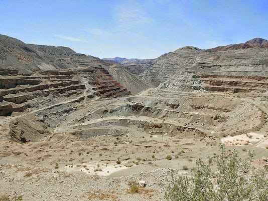
Eagle Mountain legal battle settled after 15 years

A massive iron ore mining pit at Eagle Mountain in the remote desert just east of the Coachella Valley. (Jay Calderon, The Desert Sun)

Sammy Roth
The Desert Sun


A longstanding legal battle over land around the old Eagle Mountain iron mine has been settled in a deal that some activists hope could bring the mine one step closer to inclusion in Joshua Tree National Park.

The old mine has been the subject of fiery debate in recent years, with several groups fighting over its future. The owners have been trying to sell the land to another mining company, while a separate company has obtained federal approval to build a hydroelectric power plant at the site. Conservationists, meanwhile, want to see the area absorbed by Joshua Tree National Park, which surrounds it on three sides.

The legal settlements signed last month don’t directly address any of those possibilities. Rather, they require Kaiser Eagle Mountain, which owns the mine, to return to the federal government certain lands surrounding its property, which the company received as part of a land exchange 15 years ago.

Regulators say that Kaiser still has the right to mine those lands, and that the partial reversal of the land exchange is more of a technicality than anything. Bureau of Land Management spokeswoman Dana Wilson said the land’s return to federal control “doesn’t in any way relate” to the possibility of the area becoming part of the national park.

“If the park service is interested in the future in pursuing that, then we’d need to cross that bridge when we get to it,” she said.

Conservationists, though, see last month’s settlements as a major step toward the land being incorporated into Joshua Tree National Park. They’ve argued that the old mine — and the ghost town next to it — have conservation and historic value, and would allow park visitors to learn about the history of mining and steelmaking.

Donna Charpied, a local activist who brought one of the lawsuits to undo the land exchange, said Kaiser giving up its ownership of some of the land removes “a monumental stumbling block” to the national park proposal.

“We just knocked one of the heads off the hydra,” she said. “Time to get that land back to the park now. There’s no reason not to.”

It’s unclear what prompted Kaiser to agree to the settlement, after years of fighting Charpied and the National Parks Conservation Association in court. Kaiser Eagle Mountain Vice President Terry Cook said the company could have demanded it get back the lands it gave up 15 years ago, but that it decided to be “magnanimous” by letting the federal government keep them.

Those lands are important because of their conservation value. The Bureau of Land Management said in a statement that they include critical habitat for threatened and endangered species, including the desert tortoise, the flat-tailed horned lizard and the Yuma clapper rail.

“We thought long and hard about it, and we decided we’d let the (Bureau of Land Management) retain the lands, even though we were entitled to receive them back,” Cook said. “We’re trying to do the right thing by people.”

It’s possible that Kaiser had other motives for agreeing to the settlements as well. David Lamfrom, who works for the National Parks Conservation Association, speculated that the company might be trying to ease a potential sale to another mining company.

“Having a longstanding lawsuit over the raincloud of any prospective buyer just makes things so much more complicated,” he said.

It’s also unclear what the settlements mean for the hydroelectric power plant proposed by the Eagle Crest Energy Company. The Federal Energy Regulatory Commission granted a license for the plant earlier this year, but Kaiser has thus far refused to sell its land to Eagle Crest.

The possibility of a sale could be more remote now, since some of the land that Kaiser returned to the federal government could be needed for the hydroelectric plant. Cook, Lamfrom and Charpied all said they weren’t yet sure what the reversal of the land exchange means for Eagle Crest’s proposal.

Conservation groups and the National Park Service have vehemently opposed the hydroelectric project, saying the power plant would drain billions of gallons of groundwater from an aquifer adjacent to Joshua Tree National Park.

The Eagle Crest Energy Company first proposed the hydroelectric project two decades ago — a move that angered Kaiser executives, who at the time had endorsed a plan to build a massive garbage dump at Eagle Mountain. That plan, which fell through last year, would have involved Kaiser selling its land to the Sanitation Districts of Los Angeles County, which would have built the landfill.

In preparation for that sale, Kaiser executed a land swap with the federal Bureau of Land Management in 1999. That land exchange was the source of the legal controversy that was finally settled last month.

As part of the original land exchange, Kaiser gave the federal government land it owned alongside the Eagle Mountain railroad, which stretches from the eastern shore of the Salton Sea to the mine site. In exchange, the company received federal land surrounding the mine, which would have been used for the landfill project.

But conservation groups have long criticized the exchange, saying that it was carried out illegally and that federal land managers got the worse end of the deal. They’ve also argued that the exchange is no longer necessary now that the landfill plan has been scrapped.

Now, those groups have succeeded in reversing part of the land exchange. The reversal may or may not have practical implications — Kaiser could still mine the exchanged lands — but Lamfrom sees the end of the long-running legal battle as critical to Eagle Mountain’s future.

“This is a milestone that I think gets us back to a place where we can start having reasonable discussions about what the future of this landscape is,” he said.

Lamfrom’s organization supports studying Eagle Mountain for inclusion in the national park, saying that setting aside the area would connect important fragments of wilderness.

National park officials have agreed that preserving the area would be beneficial. Such a step would require action by Congress or President Barack Obama’s administration.

Industrialist Henry Kaiser founded the iron mine in the 1950s, on land that was carved out of the southeastern corner of the Joshua Tree National Monument — the predecessor to the national park. But the mine was shut down in the early 1980s as production of steel in the United States waned.

Federal and state regulators maintain that Kaiser never gave up its mining rights at Eagle Mountain, although local activists have contested that claim. Charpied and others have accused Kaiser of conspiring with state regulators to keep control of the site, which still has millions of tons of valuable iron ore.

December 13, 2014

Arizona farmers take hit to stave off water crisis

Rock Island’s “bathtub ring” illustrates how the water level at Lake Mead has dropped. It is at 1,085 feet, 10 above a level that would trigger supply reductions. (Mark Henle/The Republic)

Brenna Goth
The Arizona Republic


All it takes is 10 feet of water to go from caution to crisis on the Colorado River.

That's why Arizona farmers like Dan Thelander support a new agreement that will help conserve the amount of water in Lake Mead even though it could mean short-term sacrifices for them.

The water level at Lake Mead is currently at about 1,085 feet above sea level, hovering near its lowest point since the dame was built in the 1930s. A drop of 10 more feet to the U.S. Bureau of Reclamation's official tipping point of 1,075 feet would trigger swift and significant supply reductions.

Arizona agriculture would be the first to take a hit.

Under a new multistate agreement signed this week, Colorado River water users will save a portion of their allotments to store in Lake Mead and boost the lake's levels. Arizona is committing to save the most water among the states, which means some deliveries and diversions will be reduced to keep water in the system.

Thelander grows alfalfa, barley, cotton and other crops on about 5,000 acres in Pinal County. His irrigation district is taking a voluntary cut, which may affect farmers' operations.

He said it's a small price to pay to postpone the more drastic reductions they would be hit with under a shortage.

"It's kind of a bogeyman that's out there," he said. "Farmers know about it."

Under the new agreement, Arizona agencies will work with Nevada, California and the federal government to store water in Lake Mead. Residential users in Arizona are not expected to be affected by the reductions.

No one knows exactly how a shortage would play out, but Arizona will be the first to face cuts based on its junior priority to California. Reductions would hit farmers before cities like Phoenix that depend on the Colorado River supply.

The agreement's proposed 740,000 acre-feet water savings aims to keep roughly an extra 10 feet in Lake Mead by 2017, buying time for water planners as they address a system dried from drought and drawing for farms and cities across the west. An acre-foot of water is enough to supply two or three families for a year, experts say.

"We're trying to stave off a crisis," said Chuck Cullom, Colorado River programs manager for the Central Arizona Project.

After more than 14 years of drought, a shortage could come as soon as 2016, Cullom said. Lake Mead is at about 40 percent of its capacity, according to the Bureau of Reclamation.

CAP will take the largest share of the voluntary reductions, committing to saving 345,000 acre-feet of water between now and 2017. The agency manages Arizona's Colorado River water allotment for municipal and agricultural users in Maricopa, Pima and Pinal counties, using a 336-mile-long canal system.

The savings are a small portion of the water delivered or diverted for storage, but participating agencies said it's a start in addressing the imbalance between the river's supply and the demand on it.

Southern California's water district will aim to save 300,000 acre-feet, and the agency in southern Nevada will save 45,000 acre-feet. The Bureau of Reclamation's goal is 50,000 acre-feet.

Under the terms agreed to when the CAP began construction in the 1960s, Arizona's water rights are the first to go. California is guaranteed its supply, but the logistics would likely be a legal nightmare in the case of a shortage, officials said.

The lower the elevation of Lake Mead, the more severe the reductions. Under CAP's priority system, Arizona farmers are the first to lose their water, though the pinch would later apply to municipal users.

Under this week's agreement, Phoenix water customers are unlikely to notice a difference. Most of the voluntary cuts fall on irrigation districts providing water to farmers in the central part of the state.

Nine districts served by CAP will together conserve 161,000 acre-feet that they would otherwise receive from CAP before 2017 — nearly half of the agency's total savings.

For the water the districts do get, CAP is providing a discounted rate to incentivize temporary changes in farming techniques by their agricultural customers to reduce water use.

"Hopefully, economically, it's about a wash," said Paul Orme, a lawyer representing three of the participating districts.

The Maricopa-Stanfield Irrigation and Drainage District, where Pinal County farmer Thelander is a board member, will take a voluntary 20,000 acre-feet cut in its CAP water supply next year.

Keeping more water in Lake Mead will avert a shortage declaration and give farmers more time to plan, said Brian Betcher, general manager of the district. Water is their most expensive input, and it's difficult to change crops with little notice, he added.

"We have to be on top of it and see things before they come at us," he said.

The district can likely compensate for this year's voluntary reduction by increasing groundwater pumping, Betcher said. The method could, however, increase rates in the future, depending on power and energy costs.

"We're looking at it as giving a little to hopefully save a lot," Betcher said.

A CAP fallowing program already in place in Yuma will also contribute to the Lake Mead savings. The remainder of the goal comes from yearly operational decisions, like storing excess water unused by customers, and a deal to replace some of Phoenix's CAP water with local supplies.

Phoenix water rates won't be affected by the deal, said Kathryn Sorensen, the city's water-services director.

Other states are still deciding how they will meet their Lake Mead storage goals.

The Metropolitan Water District of Southern California doesn't have a firm proposal but is in talks with agricultural agencies and other users, said Bill Hasencamp, manager of Colorado River Resources. California's part of the agreement provides extra flexibility for using its savings for short-term drought relief until conditions improve in the state.

"We just don't know where we'll be a year from now," Hasencamp said.

The Southern Nevada Water Authority approved the agreement in recent days, spokesman Scott Huntley said. He said he didn't have information on potential projects.

The agreement is a sign of the shifting dialogue about managing the Colorado River, said Dave White, an Arizona State University associate professor who focuses on water policy. The looming pressure of a shortage is fueling cooperation among states that have historically fended for themselves, he added.

While the West's water solutions for the past 100 years have relied on the engineering of dams and reservoirs, the next 100 years will depend on collaboration, said White, who works for ASU's School of Community Resources and Development and the Global Institute of Sustainability.

Recent agreements at the local and regional level may focus on small-scale pilot projects, but they are important because of the proactive thinking they show, White said. Any relief will give water managers time to plan — or to let nature do the work.

"Essentially what they're trying to do is buy time," White said. "This is a more sophisticated version of the 'pray for rain' strategy."

County Pushing Daggett, Yermo & Newberry Springs CSD Mergers

Map of existing Daggett (green), Yermo (blue), and Newberry (purple) Community Service Districts. (SBC LAFCO/ESRI)
San Bernardino Sentinel

The San Bernardino County Local Formation Commission has recommended that the Daggett Community Services District consolidate with two other nearby community service districts. This week the Local Agency Formation Commission reviewed a draft plan, the centerpiece of which is that the Daggett Community Service District, the Yermo Community Services District and the Newberry Community Services District be merged to form one district.

Under that recommendation, the services for all three communities would be provided in common and consolidated.

The Local Agency Formation Commission staff has formulated a so-called “plan for service” that would make for consistent service levels, allow for the free distribution of resources between the entities and communities, streamline governance and management and reduce overall costs. A five-year projection shows the newly-formed district would remain fiscally solvent for at least half a decade, with no diminution of service levels in any of the three communities.

Daggett encompasses 26 square miles and is home to 487 residents. Newberry Springs covers 117 square miles and has 2,288 inhabitants. Yermo, at 74 square miles, boasts a population of 1,629. Despite the size differences between the three communities, they have similar population densities. Daggett averages 18.7 people per square mile. Newberry Springs has 19.6 residents per square mile. Yermo has a per square mile density of 22.

Within its confines, Daggett contains its own water company, which services an area beyond its borders, including several businesses and a few residences as well as Silver Valley High School, all located in Yermo.

The Yermo Water Company has long been troubled. Formerly owned by Donald Walker, the Yermo Water Company fell into severe disrepair early last decade, a situation which was exacerbated by Walker’s departure to Florida, making it difficult for his company’s customers to contact him.

As the absentee owner, Walker did not have a licensed operator available to operate the system. During the summer of 2006, the primary water tank serving the Yermo community’s water system developed a leak and customers were without water for a week in the small community near Barstow, where temperatures exceeded 100 degrees every day. The California Department of Health and the California Public Utilities Commission initiated an investigation into the matter in 2007.

A decision to pursue the appointment of a receiver was issued in May of 2009. A community-based prospective buyer surfaced and the receivership was suspended while it appeared that a sale of the system was possible. But after more than two years of negotiations, Walker refused to inform the prospective buyer how much he owed in back taxes and fines to the California Department of Health. As a result, the sale fell through. The receivership arrangement that took place in November 2012 was contested by Walker’s family but was denied by the Superior Court on March 6, 2013. Beginning in November 2012, the Yermo Community Services District took over operation of the company’s assets and in December 2013, arrangement for the Apple Valley Ranchos Water Company to purchase the Yermo Water Company in its entirety began. Preparations for that takeover are yet ongoing, as repairs to the water system are being carried out.

In its 2012-13 report, the San Bernardino County Grand Jury identified numerous shortcomings in the governance, accounting and financial management, and internal controls of the Newberry Springs Community Services District. The Local Agency Formation Commission detailed its staff to look into those issues and others pertaining to Yermo and Daggett. The upshot was a finding that it would behoove all three districts to merge and settle on management and leadership for the collective that is competent and efficient. At the very least, according to commission staff, the Daggett Community Service District and Yermo Community Services District should come together to form one entity. Economies of scale, not to mention other advantages, make it logical that the Newberry Community Services District be brought in on the merger, according to the Local Agency Formation Commission.

There have been similar consolidation imperatives and consolidations carried out involving those communities in the past. In the 1960s Daggett’s school district was forced into a shotgun marriage with the Barstow Unified School District. In 1978, the Daggett School District was able to reassert its independence, breaking away. But in that departure, Daggett had to forego assets and resources local residents felt rightfully belonged to Daggett and not Barstow.

Daggett and Yermo resisted the Local Agency Formation Commission’s push for them to merge five years ago.
While few of the residents in the Daggett, Newberry or Yermo communities look upon the pressure to merge favorably, they are subject to the authority of the Local Agency Formation Commission, which is putting each district through its paces in having to respond to the merger concept. The Local Agency Formation Commission will lay out the options outlined by its staff and present them to the three communities and their residents. On January 21, the Local Agency Formation Commission will consider those plans/options.

For a significant number of residents, there is concern that the dictates from the county seat in San Bernardino some 70 miles away will impose on them a management and operation plan that will run roughshod over local control and in some cases, at least, result in services, including emergency services, being based at locations that will be more remote and not conducive to quick response or sensitive response.

December 5, 2014

Water Woes Among Topics For 8 Governors In Vegas

A view of the Colorado River from a scenic overlook at Glen Canyon on Nov. 22, 2004, in Page, Ariz. (Photo by Jeff Topping/Getty Images)

Ken Ritter
Associated Press


LAS VEGAS (AP) — Facing dwindling water supplies, Western states are struggling to capture every drop with dam and diversion projects that some think could erode regional cooperation crucial to managing the scarce resource.

Against that backdrop, eight Western governors meeting in Las Vegas this weekend will address regional water issues, and water managers from seven states arrive next week to work on ways to ensure 40 million people in the parched Colorado River basin don’t go thirsty.

Gary Wockner, a conservationist with the Denver-based advocacy group Save the Colorado, said there’s already jostling amid the fear of empty buckets. “Everyone is trying to get the last legal drop of water,” he said.

Colorado River Water Users Association representatives deny there’s discord at their table.

“Fifteen years of drought has tightened everything. But I don’t see this as people are getting ready to fight,” said Jeff Kightlinger, general manager of the Metropolitan Water District of Southern California. That agency is dealing with a double-whammy — drought on the Colorado River and in the Sierra Nevada and Northern California.

Nevada Gov. Brian Sandoval will host Western Governors’ Association counterparts from Colorado, Idaho, Montana, New Mexico, South Dakota, Utah and Wyoming this weekend to consider several issues, including water. Two days of drought workshops follow.

“The motto is: We save the system as a whole,” said Pat Mulroy, longtime general manager of the Southern Nevada Water Authority in Las Vegas and now a senior policy fellow with the Brookings Institution.

“If we get into, ‘I’m going to win,’ and, ‘You’re going to lose,’ there won’t be a winner,” Mulroy said.
But Wockner said Colorado, Wyoming and Utah are considering dams and diversions in the mountains to capture water they’re entitled to before it reaches the Colorado and flows to the deserts.

New Mexico has plans to divert and store water from the Gila River for cities and farms before it flows into the Colorado.

“Diversions extract water from the system,” said Jack Schmidt, professor of watershed sciences at Utah State University. He just completed three years studying the Grand Canyon for the U.S. Geological Survey. “More water use and more water retention in the upper basin means less water flowing through the Grand Canyon to the lower basin.”

Schmidt referred to the Colorado River Compact of 1922 and agreements with Mexico that promise about 16.5 million acre-feet of water annually from a river system that has historically taken in about 15 million acre-feet from rainfall and snowmelt. But that amount has diminished during almost 15 years of drought. One acre-foot of water is about enough to serve two average Las Vegas homes for a year.

“You could say that we decided how to divide the pie, but the pie is smaller than anybody thought,” Schmidt said. “With climate change, it is even smaller than that.”

In Las Vegas, which virtually relies on water from Lake Mead, officials are making plans to add a $650 million pumping facility to draw from the reservoir even if levels drop below 1,000 feet above sea level. That’s the line at which Hoover Dam’s hydroelectric turbines would be idled.

The Southern Nevada Water Authority already is drilling an $800 million tunnel to tap water from the bottom of the lake, at 860 feet above sea level.

At 900 feet — so-called “dead pool” — the river would end at Hoover Dam. Nothing would flow downstream.
The lake reached its high water mark in 1983 at 1,225 feet.

The Metropolitan Water District’s Kightlinger said the seven basin states — Colorado, Utah, Wyoming and New Mexico upstream and California, Arizona and Nevada downstream — have a history of cooperating, and they have forged several landmark agreements.

A 2012 amendment to a 70-year-old treaty between the U.S. and Mexico has the river flowing south of the border again.

Last summer, water agencies in Denver, Los Angeles, Las Vegas and Phoenix began an $11 million pilot program with the federal government to pay farmers, cities and industries to cut use of Colorado River water.

The goal is to prop up Lake Mead, which stood Friday at 1,084 feet above sea level — just 9 feet above the crucial 1,075 level that would trigger cuts to Arizona, Nevada and California.

The federal Bureau of Reclamation this week projected a better than 50 percent chance that it will declare such a shortage in January 2017.

The Central Arizona Project would face the first cutbacks, and farmers would be hit hardest, agency chief David Modeer said.

“Hoping for snowpack is not sufficient to solve this,” Modeer said. “It’s going to take cooperation and sacrifice among all of us to stave off disaster in the river.”

November 25, 2014

SMWD establishes agency to oversee Cadiz groundwater project


By TOMOYA SHIMURA
Orange County Register


A project that will pump drinking water from a Mojave Desert aquifer and pipe it to south Orange County has taken another step forward.

The Santa Margarita Water District board of directors recently approved establishing the Fenner Valley Water Authority to control and operate the delivery of the groundwater.

The district is moving forward with the plan after an Orange County Superior Court judge in May shot down lawsuits filed over the Cadiz Valley Water Conservation, Recovery and Storage Project by environmental groups trying to stop the project.

District spokesman Jonathan Volzke said operating under the joint powers authority shields Santa Margarita and its customers from liabilities.

Los Angeles-based Cadiz Inc. plans to install wells to capture water from the natural aquifer that lies beneath 70 square miles of remote valley east of Twentynine Palms. The private developer which owns the land would also build an underground 43-mile pipeline along railroad right-of-way to the Colorado River Aqueduct, which delivers water to Southern California residents.

Cadiz is estimated to spend $225 to $275 million for the construction, spokeswoman Courtney Degener said.

There’s no timeline for the beginning of construction, Degener said. The company needs to reach an agreement with the Metropolitan Water District of Los Angeles on moving water through its aqueduct, she said.

The opposition has so far filed appeals in four of the six lawsuits, but the project will continue moving forward regardless, Degener said.

The well would pump some 16 billion gallons of water a year, and Volzke said Santa Margarita plans to purchase at least 5,000 acre feet a year, or 20 percent of its water supply, from the Cadiz project. The district serves 165,000 people in Coto de Caza, Ladera Ranch, Rancho Santa Margarita and parts of Mission Viejo and San Clemente.

Santa Margarita buys 85 percent of its water from the Metropolitan Water District, which has increased water prices each year for the last two decades, Volzke said. The Cadiz project could reduce the district’s reliance on the Metropolitan Water District.

“It would give us more local control over the cost of water,” Volzke said.

Once built, Cadiz plans to lease the facilities to the Fenner Valley Water Authority, which will oversee day-to-day operation of the well and pipeline.

Cadiz is trying to reach an agreement with other water agencies that have shown interest in buying water from the project, Degener said. They include: Jurupa Community Services District, Golden State Water Company, Suburban Water Systems, California Water Service Company and Three Valleys Municipal Water District, San Luis Water District and Lake Arrowhead Community Services District.

November 20, 2014

BLM rejectes application for Silurian Valley energy project

Kailah Miles,11, of Apple Valley and her brother Rex, 8, walk back to their family's campsite at the Dumont Dunes in the Silurian Valley. The BLM rejected an energy project in the area. (Gina Ferazzi / Los Angeles Times)

By JULIE CART
Los Angeles Times


The Bureau of Land Management on Thursday denied a Spanish company's application to build a controversial renewable energy facility in the Mojave Desert's remote Silurian Valley, deciding the sprawling project “would not be in the public interest.”

The closely watched decision is considered a bellwether for how the federal agency will handle future requests to develop renewable energy projects outside established development areas.

The company had planned a side-by-side wind and solar facility. Thursday's decision applies only to the solar portion of the project. The wind energy aspect is still in the planning stages.

Jim Kenna, the BLM's California director, made the decision, finding that Iberdrola Renewables' proposal would have industrialized 24 square miles of “a largely undisturbed valley that supports wildlife, an important piece of the Old Spanish National Historic Trail, and recreational and scenic values.”

Kenna said he had been discussing the matter for weeks with field personnel and found the evidence “pretty persuasive.”

He cited concerns that the project would degrade the quality of the wilderness surrounding the site, located between two national parks. He also noted potential hazards to the desert tortoise and other impacts that could not be mitigated.

“It was fairly clear to me,” he said.

Iberdrola Renewables had sought permission to build its project using a “variance” process. Had it been approved, it would have been the first major exception to federal land managers' “guided development” approach across more than 22 million acres of California desert. Under the policy, companies are encouraged to develop in areas that have been pre-approved for projects, where there would be less environmental or wildlife conflict.

Kenna said the variance process was intended to be rigorous. In denying the application, no other message was intended other than the specific project was unsuitable for the specific site, he said.

Iberdrola began the application process three years ago and had envisioned completing construction by December.

In a statement, Iberdrola said it was weighing whether to appeal the decision to the U. S. Department of Interior.

“It is unfortunate that the variance process is enabling unsubstantiated discretion in advance of a proper National Environmental Policy Act review that should be based on clear and understandable predictable requirements,” the statement said.

But the BLM decided that the project would have “too great of an impact on the resources.”

Among the specific concerns the BLM noted were that the facility would disrupt migration corridors critical to bighorn sheep and other wildlife.

“We are quite pleased that the BLM made this decision,” said Kim Delfino, the California program director for Defenders of Wildlife. “It's encouraging that they are taking those criteria seriously.”

The wind and solar plants that Iberdrola proposed would have been encircled by protected lands. The entire project site that the company proposed sits atop the Old Spanish Trail, a historic trail managed by the National Park Service, which opposed the project.

In its application, Iberdrola said the plants would create 300 construction jobs and generate about 400 megawatts of power.

The BLM is under pressure to meet the administration's goal of generating 20,000 megawatts of power from federal land by 2020. There have been 460 applications for renewable-energy-related projects in California since 2007, Kenna said. The BLM has approved 18 applications.

November 8, 2014

Feds to flood Grand Canyon to distribute sediment

Glen Canyon Dam water release in 2013. (Bureau of Reclamation)

Associated Press
Arizona Republic


PAGE — Campsites along the Colorado River through the Grand Canyon will be in shorter supply as federal officials flood the waterway.

The high-flow release from Glen Canyon Dam in northern Arizona is scheduled to start Monday and end Friday. It's the third under an innovative science-based experimental plan approved in May 2012.

Tons of sediment from river channels will be re-deposited along downstream reaches as sandbars and beaches along the river. Grand Canyon officials say most campsites will be smaller and some low-lying sites might not be usable.

Most of the sediment once deposited throughout the Grand Canyon now is trapped behind the dam near the Arizona-Utah border. The intent of the flooding is to mimic pre-dam conditions.

The Arizona Game and Fish Department says the release should enhance trout fishing.

Will renewable energy ruin an 'irreplaceable' Mojave desert oasis?

The BLM has called the Silurian Valley an "undisturbed, irreplaceable, historic scenic landscape." But now the federal agency is considering a proposal for two solar facilities amid the oasis

Highway 127 cuts through the landscape in the Mojave Desert, carrying tourists, campers and hikers to Joshua Tree and Death Valley. (Gina Ferazzi)

By JULIE CART
Los Angeles Times


In one of the hottest, driest places on Earth, velvety sand dunes surround dry lake beds that, with luck, fill with spring rains. Hidden waterways attract a profusion of wildlife and birds; submerged desert rivers periodically erupt in a riot of green.

The federal Bureau of Land Management describes the Silurian Valley as an "undisturbed, irreplaceable, historic scenic landscape."

Now, a Spanish energy firm is proposing a wind and solar project that would cover 24 square miles of the Mojave Desert oasis.

Iberdrola Renewables wants to build a 200-megawatt wind farm that would sprout as many as 133 turbines reaching heights of 480 feet. Next door would be a 200-megawatt solar facility with 400 pairs of photovoltaic panels. The industrial facility would operate around the clock and be visible from nearly every point of the valley.

If approved, the project would be the first major exception to the BLM's strategy of guided development across more than 22 million acres of California desert.

The BLM's approach aims to encourage development in less-sensitive parts of the Mojave. But the agency allows developers such as Iberdrola to apply for variances — critics call them loopholes — that let energy prospectors plant their flags just about anywhere in the California desert if they successfully clear hurdles designed to discourage building in environmentally fragile areas.

Iberdrola's experience will help developers determine whether the difficult process is worth their time and money. For environmentalists, it will be a test of the government's commitment to protect sensitive areas of the desert.

In its application, Iberdrola said the plants would create 300 construction jobs and about a dozen full-time positions once the facilities are completed. It would require building 45 miles of new roads, a new power substation and 11 miles of transmission lines to connect the site to the power grid. The two plants would generate about 400 megawatts of power.


There has been wide position to the project, which sits astride the Old Spanish Trail, a historic trade route managed by the National Park Service.

The U.S. Fish and Wildlife Service and California's Department of Fish and Wildlife have criticized its proposed location: a valley that serves as a crossroads for three major wildlife corridors and an important avian flyway. They warned that the long-standing migration corridors would be disrupted and wildlife would be injured or killed in the wind project's turbines or the solar project's superheated panels.

This lonely place is a tourist mecca too. The valley's volcanic mesas and creosote forests are bisected by Highway 127, a two-lane black ribbon that connects three jewels of Southern California: Joshua Tree National Park, the Mojave National Preserve and Death Valley National Park.

Mark Butler, who retired this year as superintendent at Joshua Tree, said energy developments in the desert must be smartly placed to protect sensitive ecosystems.

"I believe it would be a mistake to place this in the Silurian Valley," he said. "We need renewable energy — it's just about where it is and how we go about it."

Conservation groups, which have opposed variance exceptions, say the Silurian Valley is a poor testing ground for the process.

"They are proposing something that has such grave impacts, that benefits so few and harms so many and is opposed by so many," said David Lamfrom, the associate director of the California Desert program for the National Parks Conservation Assn., a nonprofit, nonpartisan organization.

Iberdrola representatives declined requests for an interview.

Some local officials have sent letters to Congress opposing the project, in part because they fear industrialization could mar the valley and deter tourists.

Le Hayes, who for 23 years was the general manager for the town of Baker, called the proposed energy plants the latest example of "the ongoing pillage of the desert, scraping off thousands of acres to generate electricity so the metropolitan areas can light their streets, big box parking lots, etc."

Proponents of the projects say the plants will become an engine for job creation in San Bernardino County, while others cite the need for more clean energy sources to combat climate change.

Siting renewable energy on public lands in the West is a priority for the Obama administration, which has pledged to generate 20,000 megawatts of power from federal land by 2020. There have been 375 applications for renewable-energy related projects in California since 2007, BLM State Director Jim Kenna said. The BLM has approved 18 applications.

The proposal comes as both solar and wind facilities are facing criticism over bird fatalities.

Three solar farms were examined in a recent report from the National Fish and Wildlife Forensics Laboratory. The investigation concluded that one of the plants was a "mega-trap" for insects, attracting birds that later died. The report described birds igniting as they chased after their insect meals and flew into the plant's concentrated solar beam. Workers at the site referred to the smoking birds as "streamers," according to investigators.

At the Ivanpah project near the Nevada border, investigators saw "hundreds and hundreds" of dead dragonflies and butterflies that had been attracted to the luminescence generated by 170,000 mirrors focused on a 450-foot glowing tower.

Other birds, the report said, died after striking photovoltaic panels or other structures. The report did not offer a definitive number of annual deaths, because investigators only observed the sites on a few occasions, but they collected more than 200 birds from 71 species.

BrightSource Energy, which developed Ivanpah, reports avian mortality to the California Energy Commission monthly and said investigators' estimates were greatly exaggerated.

When it comes to permitting renewable energy projects such as Iberdrola's, the BLM employs a carrot-and-stick approach.

To encourage companies to develop projects in less sensitive zones, it offers fast-tracked permitting and streamlined environmental review. The shortened process can take less than two years.

The stick comes down on companies seeking to develop outside designated areas, known as Solar Energy Zones. Those projects are relegated to the back of the line, and the companies must pay for costly environmental analysis.

Iberdrola is the first to use the variance process. Its development plan will have to pass muster on a 25-point review that examines potential effects on air and water, cultural resources, wildlife, parks and other conservation lands. Developers also must demonstrate that they have the financial and technical resources to complete the project. The projects' plans are open to public comment.

"It was always anticipated to be a rigorous process," Kenna said.

The variance decision for Iberdola's Silurian Valley project rests with Kenna, who said he will rule early this month. Should he deny the application, Iberdrola may appeal to the Department of the Interior's Board of Land Appeals.

Iberdrola originally had envisioned completing construction by this December. Three years after beginning the process, not a spade of dirt has been turned.

"Given the often-stated desire of the current administration to responsibly develop more renewable energy on the large amount of federally owned lands, the actual reality of the variance process they've initiated seems to be somewhat at odds with that desire," Iberdrola spokesman Art Sasse said in a statement.

Solar companies argue that the variance process is critical to allow industry to choose its own sites.

Environmental groups are watching to ensure that companies such as Iberdrola meet the strict requirements meant to protect natural treasures like the Silurian Valley.

"There was a high bar put in place and a lot of scrutiny," said Kim Delfino of Defenders of Wildlife. "We … very much feel this is a test for the BLM."

The park service has said the visual impact would be "significant, irreversible and likely unmitigatable."

November 7, 2014

Section of National Trails Highway to reopen

Public Works equipment repairing a section of National Trails Highway between Newberry Springs and Ludlow to repair road damage caused by flash flooding. (@CountyWire)

@CountyWire
County of San Bernardino


Public Works is planning on reopening the section of National Trails Highway from Hector Road to Crucero Road, in the Newberry Springs/Ludlow area, by Friday, November 7.

Severe thunderstorms blasted the Mojave Desert September 7 and 8 triggering flash floods throughout the desert regions. Closure of I-95, I-40, National Trails Highway (Route 66), Needles Highway, and various other desert roads occurred due to washouts and bridge damage.

The most extensive damage was along National Trails Highway where approximately 40 bridges were damaged along with major portions of the roadway. Sections between Hector Road to Crucero Road (Newberry Springs/Ludlow, area), Crucero Road to Amboy Road, and Cadiz Road to Mountain Springs Road at I-40 have been closed pending roadway repairs, shoulder repairs and bridge evaluations.

Public Works crews have been working diligently to make these repairs. This is the first stretch of the road to be reopened since the storms occurred.

It is anticipated the section of roadway between Crucero Road and Amboy Road will be open by the end of December 2014 and the section between Cadiz Road and Mountain Springs Road at I-40 by the end of January 2015. All of these time frames could vary depending on the weather.

November 2, 2014

A new push for protecting public lands in the desert

Joshua Tree National Park, Wednesday, October 29, 2014. (Jay Calderon)

Ian James
The Desert Sun


Twenty years ago, President Bill Clinton signed the California Desert Protection Act, turning Joshua Tree and Death Valley national monuments into national parks, creating the Mojave National Preserve, and establishing more than 3.6 million acres of wilderness areas across the Mojave Desert.

On the anniversary of those sweeping changes, conservationists are rallying around a plan by Sen. Dianne Feinstein to relaunch legislation that would further expand protected areas in the desert and create two new national monuments – one of them stretching from the desert oases of the Whitewater Preserve and Big Morongo Canyon to the alpine forests of the San Bernardino Mountains.

The Democratic senator introduced the original California Desert Protection Act, which was enacted on Oct. 31, 1994, and calls the law one of her proudest legislative accomplishments. Feinstein plans to join the 20-year anniversary celebrations speaking at a Nov. 6 event hosted by The Wildlands Conservancy at the Whitewater Preserve.

"The 1994 law was a great first step, but there is broad consensus that more needs to be done," Feinstein said in a statement ahead of her visit. "I plan to introduce an updated bill in the new Congress that will balance the needs of this land, protecting the most fragile regions, setting aside other land for recreation use and allowing the state and local communities to benefit from this bill."

The legislation, which is expected to be introduced in January, is an updated version of a bill that Feinstein has been promoting since 2009.

While the details have yet to be announced, the proposal centers on creating two new national monuments covering more than 1 million acres. It would establish the Sand to Snow National Monument, stretching from near Joshua Tree National Park to Mt. San Gorgonio, as well as the Mojave Trails National Monument, between Joshua Tree and the Mojave Preserve, including a historic stretch of scenic Route 66.

That status would heighten the level of protection for vast areas of desert with a rich variety of plants and animals ranging from desert tortoises to bighorn sheep. The bill would also designate additional federal lands as protected wilderness and would designate four areas as recreational sites for off-road vehicles.

Those steps will ensure wildlife "corridors" and help keep ecosystems intact, said April Sall, conservation director of The Wildlands Conservancy.

"It's a pretty important ecological hotspot, and it's a great opportunity to highlight that and at the same time create a tourist attraction and provide great access points for the public to enter the wilderness," said Sall, whose organization administers the Whitewater Preserve and is supporting the creation of new wilderness areas.

The national monuments proposed by Feinstein would include areas that are also separately proposed for protection under the Desert Renewable Energy Conservation Plan, which would divide 22.5 million acres of the desert into zones for solar and other energy projects, conservation lands, and recreation sites.

David Lamfrom, associate director of National Parks Conservation Association, said that by creating additional national monuments, Feinstein's bill would make an area that has already grown increasingly popular as a tourist destination even more attractive.

"As the world gets smaller, our wide open spaces and our starry skies become really what everybody else is looking for," Lamfrom said.

The lure of Joshua Tree for visitors has grown markedly since it became a national park and was expanded under the California Desert Protection Act. The numbers of visitors have grown from less than 1.2 million in 1994 to what is expected to be a record 1.5 million visitors this year.

Those hikers, climbers, campers and others have brought a growing economic boost to communities such as Twentynine Palms and Joshua Tree, where motels, restaurants, and gas stations depend largely on out-of-towners during the cool winter months.

"The protection of the desert land all around us is extremely important because visitors come to escape urban America," said Vickie Waite, executive director of the Joshua Tree National Park Council for the Arts, which is coordinating a series of events celebrating the 20th anniversary of the 1994 law.

The anniversary events include hikes, speeches, receptions and the unveiling of a new mural in communities across the desert.

Those attending the anniversary events will include Pat Flanagan, a naturalist who leads nature walks at the Oasis of Mara.

"Something as monumental, congressionally monumental, as this should be celebrated, and every 10 years is a good time to do it," Flanagan said.

She praised Feinstein's work in backing the legislation 20 years ago, and recalled that those changes took years to win approval after an initial version was introduced by Sen. Alan Cranston in 1986.

"This is not easy work, and you have to have a long vision," Flanagan said.

The work of creating Joshua Tree National Park and the other desert wilderness areas goes back a century and has involved many contributors.

Minerva Hamilton Hoyt for years championed the creation of a national park before President Franklin D. Roosevelt established Joshua Tree National Monument in 1936. By 1950, the size of the park had been reduced significantly to make room for mining of iron and gold.

During the past two decades, the national park has been expanding, though it remains significantly smaller than the original national monument created by FDR. That gradual expansion has been boosted by the Mojave Desert Land Trust, a nonprofit formed in 2005, which has bought 123 properties totaling 7,500 acres.

Danielle Segura, the organization's executive director, said the 1994 law guides its work and is "a hallmark for protecting open spaces for the public."

At the park headquarters, Superintendent David Smith has a series of maps on his wall showing how the boundaries of Joshua Tree National Park have changed since 1936.

"This is the boundary that FDR created for the park, in his opinion, working with conservationists at the time," Smith said, standing beside the map. "He thought this was a realistic appraisal of what the park should be. I think we're trying to replicate that. We're looking at more, broader ecosystem management."

Smith said that includes working on ways to link the national parks and other protected areas to allow for migration corridors, and also working with other agencies to protect wilderness areas outside the park.

Those tasks take on even greater importance, he said, as the park plans for threats including global warming and fires fueled by invasive weeds – which scientists predict could lead to the disappearance of Joshua trees in much of the park by the end of the century.

"It's a bigger picture. It's more than just the boundaries around the park," Smith said. "Yeah, we've come a long way in preserving some of these desert places, but now we've got to look outside."

October 31, 2014

Suspect identified in 8 graffiti vandalism cases in National Parks

Casey Nocket identified as prime suspect In 'Creepytings' national parks vandalism (Modern Hiker)

By Steve Gorman
Reuters


LOS ANGELES — Federal officials have publicly identified a woman suspected of graffiti vandalism in at least eight national parks across the West, including Yosemite and Death Valley in California, and credit social media for helping pinpoint the alleged culprit.

Casey Nocket of New York state has not been arrested or charged but was confirmed Thursday as “the major suspect” in an investigation of one of the most widespread acts of serial vandalism documented in the National Park System.

The case was brought to light in a series of photos obtained and posted by the Internet blog Modern Hiker and furnished to the National Park Service picturing numerous graffiti drawings, all signed “Creepytings” and dated 2014.

One shows a woman the blog identified as Nocket putting the finishing touches on an acrylic drawing of a cigarette-smoking figure scrawled on a canyon wall at Utah’s Canyonlands National Park in June.

Others show drawings of a woman with blue hair on a ledge overlooking Oregon’s Crater Lake and a bald man with a snake protruding from his mouth on a trailside rock in California’s Yosemite National Park.

The Park Service said initially it was investigating such vandalism in at least 10 Western national parks.

But agency spokeswoman Alexandra Picavet said Thursday that Nocket had been tied as a suspect to graffiti in eight parks: Yosemite, Death Valley and Joshua Tree in California; Crater Lake in Oregon; Zion and Canyonlands in Utah; and Rocky Mountain National Park and Colorado National Monument in Colorado.

Although instant gratification afforded by social media exposure was cited in a New York Times report last year for a rise in graffiti defacings on public lands, Picavet said social media in this case played a key role in the investigation.

The Modern Hiker said its photos were gathered earlier this month by screen shots taken of the suspect’s Instagram and Tumblr accounts, which have since been set to “Private.”

Park Service investigators also received numerous photos and other information from members of the public outraged over the defacings, Picavet said.

Vandalism is a federal misdemeanor punishable by up to a year in jail and a $5,000 fine, although prosecutors could decide to bring more serious charges.

“This is an open investigation,” Picavet said.

Yosemite spokeswoman Kari Cobb said vandalism occurred there occasionally but was “not common.” She added: “As far as a widespread case like this, it’s the first one I’m aware of.”

October 30, 2014

Desert act turns 20, what it saved

Hikers climbing up to Keane Wonder mine in Death Valley National Park. (Rita Beamish)

By Deborah Sullivan Brennan
San Diego Union-Tribune


Twenty years ago today, the California Desert Protection Act designated 7.6 million acres of the state’s backcountry as wilderness.

Portions of that land had been mined, grazed and used illegally for off-roading.

For desert lovers such as Nick Ervin of San Diego, California’s deserts represented a wide-open expanse of solitude and stillness, just hours from the state’s biggest cities. After surveying what he saw as damage to them from human activities, he found a chance for restoration.

Nick Ervin, activist.
Ervin joined fellow Sierra Club activists to spearhead San Diego County support for the Desert Protection Act, first introduced by Sen. Alan Cranston and then shepherded through Congress by Sen. Dianne Feinstein.

The legislation established the 1.6 million-acre Mojave National Preserve and designated Death Valley and Joshua Tree as national parks. It also set aside as wilderness smaller tracts in San Diego and Imperial counties, including the Fish Creek, Coyote and Sawtooth mountains near Anza-Borrego Desert State Park.

The bill faced opposition from people who feared it would engulf private land, ban visitors from wilderness areas and forbid popular activities such as hunting and off-roading. The debate escalated into scuffles at times, Ervin remembered.

In the end, the law didn’t secure the pure, unaltered wilderness that some proponents sought. Certain mining and grazing operations were grandfathered in, and hunting continues in the Mojave National Preserve.

Motor vehicles aren’t allowed in wilderness zones. But adjoining land and some roads that traverse the protected acreage are still open to traffic that includes off-road vehicles, said Paul Turcke, an attorney who has represented off-road enthusiasts nationwide. Litigation over the desert access remains to this day, he said.

The legislation became law on Oct. 31, 1994, when then-President Bill Clinton gave it his signature. For the 20th anniversary milestone, Ervin, a retired psychotherapist who now teaches at National University, talked with U-T San Diego about his efforts to preserve the state’s open spaces. Here is an edited version of that discussion:

Question: How did you get involved in the campaign to pass the California Desert Protection Act?

Answer: I was active in the local chapter of the Sierra Club in the late ’70s early ’80s. ... Some big conservation activists in Los Angeles gathered information and then approached Sen. Alan Cranston about sponsoring a bill in Congress to rectify the big problems with how the desert was being run over by off-road vehicles, reckless mining, reckless grazing and uncontrolled urban development around desert cities. They said we need organizers in San Diego and Imperial counties.

Question: What was your particular role?

Answer: I and two other organizers ... followed the bill from 1988 to 1994. We wrote articles, we did letter-writing campaigns. I did old-fashioned slide shows — it wasn’t PowerPoint in those days. I did garden clubs, classroom presentations. We wrote op-eds.

Question: What were the challenges to securing support for desert protection?

Answer: There was a belief that it’s an empty waste, where there’s not much life. Or it’s a fearful place with rattlesnakes and scorpions. It’s a harder sell to the general public than forests or lakes.

Question: Why did you believe the cause was important?

Answer: I had been hiking in the desert for years and years, and had seen how outside of Anza-Borrego Desert State Park, there were lots and lots of off-road activities. ... Desert foliage is very slow to heal and very fragile. You can do hundreds of years’ worth of damage in an afternoon with an off-road vehicle that is poorly used.

Question: What does the act mean for San Diegans?

Answer: It means that a lot of the desert lands around Anza-Borrego park have the highest official protection status that you can give any land in perpetuity. It would require an act of Congress to reverse the Desert Protection Act.

Question: What were your responses to critics who said the law imposes restrictions on too much land?

Answer: There were meetings in the late ’80s that were big-time contentions. There was actually some pushing and shoving going on. ... I personally got hate mail. They were typically centered around one accusation that we were locking up desert land against the average citizen. ... The old stereotype was we were watermelons — green on the outside and red on the inside. People said it was a communist plot, socialism in action in the California desert.

Question: What were the eventual accommodations for existing uses such as wildlife management, hunting and grazing?

Answer: One of the big concessions was the Mojave National Preserve (instead of it becoming a national park). There were several concessions that hunting would permanently allowed. ... Back then, there were people doing grazing on federal lands under a lease, who were really afraid of losing their grazing rights. Dianne Feinstein said we will never force you to sell (grazing rights). That was a pretty big concession. There’s always been a big debate about guzzlers (artificial water sources built to aid wildlife). The Desert Protection Act doesn’t really address what guzzlers should be allowed and where. And that debate goes on.

Question: What do you think about the status of the California desert today and the role of energy developments such as solar and wind farms?

Answer: As preservationists we’ve been torn, because as preservationists we support renewable energy. But some of us on the desert land (issue) object to some of these developments because the government is sometimes allowing them on lands that are not already burned out agricultural lands, or toxic waste sites and brownfields. They’ve allowed some of these developments on pristine, high-quality desert habitat and not next to existing power lines. ... We’re also arguing for more rooftop development in cities, where the energy is used. Renewable energy and where it’s to be sited is the argument for decades ahead.

October 22, 2014

Southern California Desert Management Plan Worries Activists

A sweeping renewable energy management plan for Southern California's desert regions is stirring fears about potential new solar farms and transmission lines in San Diego and Imperial counties.

California power lines, Feb. 21, 2011 (Robert Couse-Baker)
By Erik Anderson
KPBS.org


A sweeping renewable energy management plan for Southern California's desert regions is stirring fears about potential new solar farms and transmission lines in San Diego and Imperial counties.

Federal and state officials have been crafting a desert management plan for five years.

The recently unveiled proposal would help manage development and habitat protection on 22 million acres of federal, state and privately owned land in the eastern part of the state.

The idea is to streamline the development process for renewable energy projects on about two million acres.

East County resident Donna Tisdale has fought against backcountry development for years. She's trying to get the word out that this plan could have major negative impacts.

"I had to contact a lot of farmers in the Imperial Valley to try and get them up to speed on what was going on," Tisdale said. "People in East County were kind of shocked to hear that there's at least one more 500 KV line, like Sunrise Powerlink, proposed."

Sunrise Powerlink is a 117-mile transmission line that connects San Diego with the Imperial Valley. It was put into service June 17, 2012.

The plan's architects consist of what they call "an unprecedented collaborative effort between the California Energy Commission, California Department of Fish and Wildlife, the U.S. Bureau of Land Management, and the U.S. Fish and Wildlife Service also known as the Renewable Energy Action Team."

The state and federal coalition is currently seeking public comment.

The desert energy and conservation protection plan is scheduled to be finalized next year.

October 16, 2014

ROUTE 66: After the rains, a humbled highway

Travelers are being turned away from fabled Route 66 and large sections of the historic highway have been closed since mid-September after heavy desert thunderstorms washed out bridges and undermined sections of pavement.

Route 66 heading west out of Ludlow is closed to traffic, one of several sections of the historic highway that are shut off to travelers. (Mark Muckenfuss)

By Mark Muckenfuss
The Press-Enterprise


Just try getting your kicks on Route 66 these days. It’s not easy.

Large sections of the historic highway have been closed since mid-September after heavy desert thunderstorms washed out bridges and undermined sections of pavement. In some spots there are holes large enough to swallow one of the motorcycles belonging to tourist groups that regularly retrace the Western route.

Those travelers and others now have to detour off of Route 66 between Newberry Springs and Needles, taking I-40 instead. San Bernardino County officials estimate it will take $1.4 million to fix the damage. They hope to reopen the road by late November.

For Route 66 enthusiasts, the detour is a disappointment. For those who live on the highway that brought generations of migrants west to California, the closure is more painful.

“We’re basically closed,” said Jim Wilson, 62, owner of Bolo Station Bar & Grill & RV Park, in Cadiz.
Barriers at the Kelbaker Road/Route 66 intersection 6 miles west of Wilson’s place tell eastbound motorists the road is closed to through traffic. Not many venture through to his place. The handful that do have had to turn around.

“You can get down to my place here,” Wilson said, “but right after you go over the bridge past my property (the road) is closed.”

Beyond that, there are bridges that have washed out.

“They’re bad,” he said.

Brendon Biggs is deputy director of operations for the San Bernardino County Department of Public Works. He’s overseeing a workforce of 20 to 30 people making repairs to Route 66.

“Right now it’s high on the priority list,” Biggs said. “We want to get the road open.”

The flooding that hit the region was almost unprecedented, he said.

“We had multiple locations of severe damage,” he said. “We had approximately 40 bridges damaged in some way along with the road surface itself.”

Residents in such tiny towns as Essex and Chambliss can get in and out, but everyone else has to go around.

“It definitely affects tourism,” Biggs said. “National Trails Highway (the original name for Route 66) is a big road. The most scenic areas, they’re not able to enjoy that right now. There are big holes in the road.”

ROUTE 66 DAMAGE
Where the route is closed:

• Along I-40, from the Hector Road exit to Ludlow

• East of Ludlow to Amboy

• From Kelbaker Road east to I-40

Where it's open:

• Between Amboy and Kelbaker Road

Opened: Nov. 11, 1926, though the famed "Rte 66" signs didn't go up until 1927.

Nicknames: The Mother Road, America's Main Street

Household name: Popularizing the road in the 1960s were a hit TV show starring Martin Milner and George Maharis, which ran 1960-1964 on CBS, and a top-selling pop song, "(Get Your Kicks on) Route 66," later recorded by scores of artists.

No longer super: Route 66 was removed from the U.S. highway system in 1985 because it had been replaced nationwide by a network of bigger, newer Interstate highways.

But always beloved: The road is still popular among pop-culture enthusiasts, historians, classic car collectors and tourists, particularly visitors from Europe.

October 10, 2014

Las Vegas ‘tortoise gulag’ paroles last inmates

A desert tortoise crawls free after being released into the desert near Primm on Friday, Oct. 10, 2014. The Desert Tortoises Conservation Center which housed the tortoise, relocated its final 53 tortoises before the center is scheduled closing in Dec. (David Becker/Las Vegas Review-Journal)

By HENRY BREAN
LAS VEGAS REVIEW-JOURNAL


JEAN — After years — perhaps a lifetime — in cushy captivity, desert tortoise No. 6349 spent his first five minutes of freedom hunched motionless under a bush in a rocky dry wash 40 miles southwest of Las Vegas.

Finally, as his human handlers backed away, 6349 poked his head out of his shell and started to explore his new home — slowly, of course.

He had no way of knowing it, but he marks the end of an era. He was part of the final batch to be set free in the wild before the Desert Tortoise Conservation Center shuts down for good in December, after more than 20 years at the southwestern edge of Las Vegas.

The U.S. Fish and Wildlife Service announced plans to close the 220-acre center last year, after its federal funding was eliminated. Since then, the center’s contract operator, the San Diego Zoo’s Institute for Conservation Research, has been working with its partners to empty the facility, mostly by releasing healthy tortoises into the wild.

The center was caring for roughly 1,400 of the animals as recently as 18 months ago. Today, all that remain are about 50 adults awaiting shipment to a new exhibit at the Springs Preserve, a research facility in Battle Mountain and the Best Friends Animal Sanctuary in Utah.

Another 40 hatchlings born at the center will sleep through the winter in covered outdoor pens at the site and be released into the wild next year, said Mike Senn, assistant field supervisor with the Fish and Wildlife Service in Southern Nevada.

Senn said no tortoises have been euthanized — or will be — because of the closure of the center, though some animals have been humanely killed over the past two years because they were too sick to save.

He estimates that about 30 percent of tortoises that came into the center had to be put down for medical reasons.

Since 1989, the desert tortoise has been listed as threatened under the Endangered Species Act.

The conservation center was established in the 1990s as a place for developers to put tortoises removed from job sites in booming Clark County, but it soon became the valley’s de facto shelter for unwanted pet reptiles.

Last year, the center announced it no longer would accept former pets and strays, which were pouring into the facility at a rate of about 1,000 a year, overwhelming its budget and research mission.

The center’s closure in two months will end what has, at times, been a troubled and patchwork effort to save the tortoise, even as researchers were trying to better understand the species and the reasons for its decline.

That led to mistakes.

During the center’s first decade or so, thousands of tortoises were euthanized under a policy that called for the destruction of any animal showing signs of a deadly upper respiratory tract disease considered a threat to the species. It was later learned that tortoises could test positive for the disease but never develop it, either because they had been exposed and recovered or because they could carry it without ever showing symptoms or passing it on. That led to a change in the disease protocol that dramatically reduced the number killed.

Senn said the center’s procedures for determining which tortoises to release have also improved greatly over time and so have survival rates. Early in the program, he said, “They were releasing whatever — anything that wasn’t dead.”

Longtime local conservationist John Hiatt said the center’s legacy will be decidedly mixed. He said “it seemed like a good idea” to have a holding area for tortoises that otherwise would be literally bulldozed in the name of development.

“But in the final analysis, it just wasn’t a long-term or permanent solution,” he said, especially after it became a shelter for a pet tortoise population far larger than expected.

The center has a nickname in the environmental community: “The tortoise gulag.”

“That’s what a lot of people referred to it as because tortoises went there and were put into little pens and that was it,” Hiatt said.

Friday’s release took place in an area west of Interstate 15 south of Jean known as the Large Scale Translocation Site. Of the more than 10,000 tortoises released from the conservation center since 1997, most of them have come to this 27,000-acre swath of federal land where the species’ population density is much higher than it would be under natural conditions, Senn said.

Federal officials and their state and local partners also have established other tortoise release areas at the base of the Spring Mountains south of Pahrump and in the canyons and desert south of Boulder City. A few years ago, a group of test subjects equipped with tracking devices was set loose at the Nevada National Security Site.

Studies conducted in recent years suggest former pet tortoises, even those born in captivity, survive in the wild at about the same rate as the natural population.

“It doesn’t take them very long to go out and be a real tortoise again,” Senn said. “They have that instinct.”

On Friday, it took about 25 biologists and volunteers less than an hour to release 53 tortoises. The crew spent longer driving to the site than it did emptying the animals from their plastic tubs.

No. 6349 was set free by Daniel Essary, a research assistant from the San Diego Zoo, who could find himself out of a job in December. Essary figures he has released roughly 250 tortoises into the Nevada desert over the past five years, and he noticed something familiar about the way 6349 reacted to its release by hiding in his shell.

It’s impossible to know for sure, but Essary said he would bet that 6349 wasn’t always a guest of the government or a backyard pet.

“I’m pretty sure he’s had his time in the wild before,” he said as he watched the tortoise begin to move.

Federal Court: One Million Acres Near Grand Canyon Protected From Mining

The Grand Canyon (Shutterstock)
by Ari Phillips
Climate Progress


In early October, an Arizona federal judge upheld the Obama Administration’s 2012 withdrawal of over one million acres of federal lands surrounding Grand Canyon National Park from uranium mining. Originally imposed by then-Secretary of the Interior Ken Salazar, the mining industry challenged the ban arguing that the 700-page Environmental Impact Statement was inadequate, failed to address “scientific controversies”, and was unconstitutional.

With the court’s decision to uphold the Department of Interior’s (DIO) decision, the lands around the Grand Canyon will be closed to the exploration and development of uranium mining claims for 20 years, thus protecting the Colorado River watershed and several sacred Native American sites. According to the government’s study, removing the ban would mean that 26 new uranium mines and 700 uranium exploration projects could be developed.

According Roger Clark, air quality and clean energy director at the Grand Canyon Trust, the ruling affirms conclusions by five federal agencies, including scientists from the U.S. Geological Survey — that uranium mining poses unacceptable risks to Grand Canyon’s water, wildlife, and people.

“Uranium mines threaten hundreds of the Grand Canyon seeps and springs that provide precious water to thousands of desert-dwelling species,” wrote Clark. “Every new mine sacrifices cultural sites and fragments wildlife habitat, polluting the park with dirt roads, dust, heavy machinery, noise, off-road drilling rigs, power lines, and relentless truck traffic.”

Due to the sheer size and remoteness of the landscape, the EIS authors adopted a “cautious and careful approach” to assessing the potential impacts of uranium mining. They ultimately found that “the risk of groundwater contamination from uranium mining was low, but that the possible consequences of such contamination were severe.”

Arizona federal district court judge David G. Campbell found this approach warranted, writing that “the Court can find no legal principle that prevents the DIO from acting in the face of uncertainty,” and that the Secretary of the Interior had the authority to “err on the side of caution in protecting a national treasure — Grand Canyon national park.”

When President Theodore Roosevelt created the Grand Canyon Preserve in 1906 he didn’t allow mining on much of the land, but mines were opened on land surrounding the canyon. Often on Native American lands, including the Havasupai and Navajo, these mines have become dangerous radioactive sites. There are over 500 abandoned uranium mines on Navajo territory and the federal government is still working with the Navajo to determine the best way to address the issue. According to the EPA, potential health effects include lung cancer from inhalation of radioactive particles, as well as bone cancer and impaired kidney function from exposure to radionuclides in drinking water.

“In sum, this decision supports a precautionary approach to mineral withdrawals,” wrote Hillary M. Hoffmann, an environmental law professor at Vermont Law School. “It affirms the agency’s choice, ‘when faced with uncertainty due to a lack of definitive information, and a low risk of significant environmental harm,’ to temporarily withdraw land from mineral entry before conducting a National Environmental Policy Act (NEPA) review.”

Hoffman writes that while this may run counter to general policy underlying NEPA, in this instance the Bureau of Land Management’s (BLM) actions prevented the development of thousands of uranium claims until the agency could fully study the impacts of those claims and determine whether to make a full withdrawal.

“As the district court noted, if the BLM waited to act until after the NEPA review process was complete, the claims may have become vested and at that point, it would have been too late to protect the Colorado River watershed and the Havasupai sacred sites,” she writes.

When Salazar first banned this block of 633,547 acres of public lands and 360,002 acres of National Forest land from mining in 2012, a number of politicians objected, including U.S. Senators Orrin Hatch (R-UT), John McCain (R-AZ), John Barrasso (R-WY), and Mike Lee (R-UT). Sen. Hatch said mining the land “poses no environmental threat” and that the announcement was another sign that the Obama Administration “is one of the most anti-American energy presidencies in history.”

Fast-forward two years later and there are currently 13 candidates up for election in November who want to sell or seize public lands for drilling, mining, or logging and seven senators not up for reelection, including four Arizonans: Sen. McCain, Sen. Jeff Flake, U.S. Rep. Trent Franks, and State Rep. Andy Tobin.

The uranium mining companies have 60 days to appeal Judge Campbell’s decision to the Ninth Circuit Court of Appeals and are likely to do so, according to the Center For Biological Diversity.

October 6, 2014

Wilderness as economic stimulus? A closer look at the evidence

By Shawn Regan
The Hill

There are many good reasons to love wilderness. The Wilderness Act, which passed 50 years ago this year, describes several of them: outstanding opportunities for solitude, primitive and unconfined recreation experiences, and the preservation of special places "where the earth and its community of life are untrammeled by man."

As a former wilderness ranger, these values resonate with me. More than 100 million acres of land have been designated as "wilderness" since 1964, and in my view they include some of the most spectacular landscapes imaginable.

But as hard-fought wilderness bills languish in Congress, some are claiming there's another reason to love wilderness areas – they're good for local economies.

This economic argument is a central part of wilderness advocacy today. Protecting lands from development, many say, provides a much-needed boost to rural communities. These lands attract workers, entrepreneurs and investors across all sectors while boosting income and employment in surrounding areas.

But what does the research actually say about the economic effects of wilderness designations? I took a close look at the peer-reviewed academic research and found few rigorous studies and little evidence to support the claim that wilderness leads to economic stimulus. As we celebrate the 50th anniversary of the Wilderness Act, consider what the best available research says.

First off, there is disagreement on how natural amenities such as wilderness should affect economic outcomes in theory. On the one hand, wilderness designations limit resource development and could hinder income and employment in extractive industries. On the other hand, wilderness could improve quality of life and attract new businesses, migrants and tourists. Adding to the confusion, there is evidence that workers might accept lower wages, longer periods of unemployment and higher land prices to live in areas rich in natural amenities such as wilderness.

So there's confusion about the theory, but what do existing studies find when they look at the data? In short, not much. The first empirical study, published in 1998, found no evidence that wilderness had an effect on employment or population growth in Western counties during the 1980s. A similar study in 1999 found no effect of wilderness on income, population or employment growth in rural counties in several Western states. Two more studies in 2002 and 2003 were no different: Wilderness had no effect on employment or wage growth.

More recent studies come to similar conclusions. A study in 2006 by Ray Rasker of Headwaters Economics champions the role that public lands play in stimulating income growth in the West, but a closer look reveals that he is unable to demonstrate a statistically significant effect associated with wilderness lands. Another study by Rasker and his colleagues, published in 2013, emphasizes that protected public lands (including wilderness) had a small positive relationship with three measures of income. Less obvious was the fact that seven other economic measures they examined had zero effect.

So what about the popular claim that wilderness drives economic growth? Studies that reach this conclusion are based on simple correlations. None are rigorous enough to suggest that wilderness causes growth. Two studies that are often cited — one by Paul Lorah and Rob Southwick in 2003 and another by Patrick Holmes and Walter Hecox in 2004 — report a positive correlation from wilderness and population, income and employment growth. But once additional factors are controlled for in more detailed studies, these positive relationships disappear.

More research is needed to better understand the effects of wilderness. But a critical look at the existing studies makes this much clear: There is little or no evidence that wilderness bolsters economic growth. When environmentalists invoke economic arguments to support wilderness, they are exaggerating the best-available research and undermining other more compelling wilderness values.

Wilderness advocates shouldn't hang their hats on economic arguments. There are plenty of good reasons to love wilderness areas — but there's just no evidence that economic arguments are one of them.

Regan is a research fellow at the Property and Environment Research Center (PERC) in Bozeman, Mont., and a former backcountry ranger for the National Park Service.

September 30, 2014

Judges seem skeptical of U.S. in high-stakes Utah road dispute

 PUBLIC LANDS

Kane County, Utah, R.S.2477 road claims.
Phil Taylor
E&E / Greenwire


DENVER -- A federal appeals court yesterday appeared skeptical of the federal government's claims that a lower court had wrongly awarded a Utah county and the state rights of way over desert roads in a case with possible ramifications for Utah's larger bid to assert control over federal lands.

But the three-judge panel of the 10th U.S. Circuit Court of Appeals offered few hints as to whether it would uphold a district court's decision in March 2013 to award southern Utah's Kane County rights of way over 12 of 15 roads it had claimed, four of which run through the Grand Staircase-Escalante National Monument (Greenwire, March 25, 2013).

It's a high-stakes case for Utah, whose counties have staked claims over some 12,000 roads spanning about 36,000 miles over federal lands under a Civil War-era mining law, as well as conservation groups, which note that many of those routes crisscross sensitive wilderness study areas, national parks or other public lands they've proposed remain roadless.

The 10th Circuit's ruling on the Kane case could offer legal precedent for how Utah, counties, the federal government and conservation groups negotiate resolution on thousands of other roads.

Yesterday's proceeding featured oral arguments by Department of Justice attorney David Shilton and Kane County attorney Shawn Welch.

At issue are Kane's claims to 15 roads crossing some 89 miles of federal lands under an obscure 1866 law known as R.S. 2477 that allowed miners and homesteaders to build trails or roads over any public lands not yet reserved or claimed for private use. Utah and its counties can gain title to R.S. 2477 roads if they can prove they were in continuous use for at least 10 years prior to the law's repeal in 1976.

Utah argues the law is a critical bulwark against federal decisions to block access to public lands, but conservation groups see it as one of the greatest threats to preserving wilderness-quality lands in Utah's red rock country.

U.S. District Judge Clark Waddoups last year said Kane successfully proved its case for 12 of the roads. While some are noncontroversial, the North Swag route, which Kane won, cuts through the Paria-Hackberry wilderness study area, which BLM recognized for its roadless characteristics and which environmentalists have eyed for future wilderness designation.

Both Kane County and the United States appealed the decision to the 10th Circuit, but for different reasons.

Kane and Utah argued that Waddoups was wrong to require them to prove the validity of R.S. 2477 claims by "clear and convincing evidence," rather than a lower burden of proof, and had incorrectly ruled that a public water reserve issued by President Coolidge in 1926 precluded R.S. 2477 claims.

DOJ's Shilton argued that the district court had no jurisdiction to decide R.S. 2477 claims for the Sand Dunes, Hancock and Cave Lakes roads because they had never been closed to use and therefore created no "dispute" for the court. It also claimed Waddoups had awarded rights of way widths for North Swag, Swallow Park/Park Wash and Skutumpah roads based on current, rather than 1976, uses.

The judges pressed Shilton to explain the government's first argument over jurisdiction. While the roads remained open, legal title was still in dispute.

Shilton argued the Bureau of Land Management, which oversees the tracts, has to take "some affirmative action" to trigger the court's involvement. "The United States has never closed access to those roads," he said. "You need a real dispute."

But Judge Gregory Phillips, an appointee of President Obama, said that line of reasoning could allow "decades and decades and decades" to pass without a resolution of Kane's claims. He said the government stands to benefit from delays because it makes it harder for Utah to prove R.S. 2477 claims.

In addition, Judge Robert Bacharach, another Obama appointee, pressed Shilton to defend the government's claim that Waddoups had wrongly awarded right of way widths for uses that didn't exist in 1976, such as for heavier agriculture vehicles. Bacharach spoke to a need to maintain the "current day's standard of safety."

The third judge, Paul Kelly, was appointed by President George H.W. Bush.

Panel skips enviro arguments

Notably, the panel didn't discuss arguments raised by environmental litigants in the case including the Southern Utah Wilderness Alliance, Wilderness Society, Sierra Club, Grand Canyon Trust and National Parks Conservation Association.

Those groups argued in friend-of-the-court briefs that Waddoups had failed to consider that a 12-year statute of limitations had expired for the North Swag route, making the county's claim for that route invalid.

They also argued that historical use of alleged R.S. 2477 roads by adjoining landowners, ranchers and others who enjoyed privileged access should not have counted in the Kane County case, nor in any of Utah's other road claims winding their way through the courts.

"It's disappointing," said SUWA attorney Steve Bloch. "There were significant issues that could have steered this hearing in a different direction."

Bloch noted that the 10th Circuit in April had concluded in a separate R.S. 2477 case involving the Salt Creek road through Canyonlands National Park that "proprietary use" of a road doesn't count for determining a valid right of way.

"This is one of the key take-aways from the Salt Creek decision," Bloch said. "This alone could be a basis to send this entire case back to Judge Waddoups."

Conservationists had hoped that finding would come into play in the Kane case yesterday, but it didn't.

Shilton did not raise this point before the court and declined to be interviewed after the arguments.

Welch said the merits of the Salt Creek case should not apply in the Kane case. Unlike Salt Creek, the Kane roads connect other roads and their use was less in dispute, he said.

In the Salt Creek case, the court also had ruled that frequency or intensity of use, not just whether it was used for 10 consecutive years, is important in determining whether a road qualifies as a "public thoroughfare" under R.S. 2477. For example, use by a single cattleman for driving cattle is insufficient, as is intermittent or occasional use by hunters, fishermen, shepherds, farmers and miners, the court said.

This issue also did not come up yesterday.