Showing posts with label National Parks Conservation Association (NPCA). Show all posts

August 28, 2017

Under Obama, a gold mining firm was fine with a Mojave Desert monument. Under Trump, an about-face

Aren Hall, environmental manager of the open-pit Newcastle mining operation, surveys the eastern Mojave Desert site. (Louis Sahagun / Los Angeles Times)

by Louis Sahagun
Los Angeles Times


Less than a year ago, President Obama’s designation of a new national monument in the eastern Mojave Desert — featuring a row of jagged peaks rising above native grasslands and Joshua trees — was hailed as a compromise that served the goals of conservationists and the mining industry.

The 20,920-acre monument surrounded, but did not include, an open-pit gold mining operation at the southern end of the Castle Mountains. That allowed Newcastle Gold Ltd. of Canada to proceed with plans to excavate 10 million tons of ore from its 8,300-acre parcel through 2025.

“The company appreciates that it has been consulted throughout this process,” Newcastle said at the time. “The new land designation reflects a compromise position that meets our needs as well as respecting the interests of other stakeholders in the area.”

So, conservationists said, they were caught off guard to learn Newcastle’s position shifted after the Trump administration moved to roll back federal protections on many of the monuments created by previous administrations.

Castle Mountains National Monument was not on the list of 27 sites proposed for status modification or elimination. In a plan delivered Thursday to the White House, but not released to the public, Interior Secretary Ryan Zinke said he has suggested the president make changes at “a handful” of those monuments.

Yet letters obtained through a Freedom of Information Act request show that Newcastle and Rep. Paul Cook (R-Yucca Valley) have told Zinke the designation was made without adequate public outreach or input from the company.

The firm’s recommended solution: Reduce the size of Castle Mountains National Monument by 50%.

“The company gave its word that the deal we struck nearly a year ago was good,” David Lamfrom, director of California and desert wildlife programs for the National Parks Conservation Assn., said last week. “So we’re … furious to learn that the company and its supporters have been secretly complaining that the process was unjust.”

In an interview, Gerald Panneton, chief executive of Newcastle, confirmed that the company met with Interior Department officials in June to discuss shrinking the monument. He dismissed the company’s initial cheery assessment of Obama’s designation as “words used to calm investors.”

“There were never adequate consultations with us,” said Panneton, who joined the company after the designation was made. “That’s a problem because we need room to explore and grow.”

In an opinion piece published Wednesday in the Desert Dispatch newspaper, Cook accused Obama of creating the Castle Mountains monument under the Antiquities Act “without a public meeting or public comment” as part of a “backroom deal” with conservationists. He also said Trump has specifically asked Zinke to modify the monument.

Alex Hinson, a spokesman for the U.S. Department of the Interior, declined to comment.

The area where the monument is located, about 100 miles south of Las Vegas, has a long history of battles pitting preservationists against mining, grazing and recreational interests.

In the late 1980s, plans to use a controversial gold-mining technology came under attack by environmentalists, who claimed it would dry up a perennial spring and attract wildlife to cyanide-laced water.

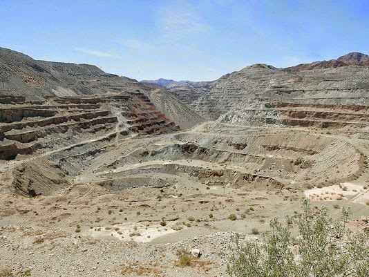
In 1994, the mineral-rich portion of land was carved out of the adjacent Mojave National Preserve at the request of Sen. Dianne Feinstein (D-Calif.), who recognized the economic value of its gold mining operations. The then-Viceroy Mine produced more than 1 million ounces of gold by the time its main pits — dubbed Leslie Ann, Oro Bell and Jumbo — were shuttered in 2001 due to low gold prices.

Standing one recent day at the edge of a mining pit dug into the mountains, Newcastle environmental manager Aren Hall smiled and said, “Impressive, isn’t it?”

Panneton said Newcastle aims to resume production next year.

“We’re more than happy to sit down with environmental groups and work out our differences,” he said. “For example, the mine could help subsidize the monument and Mojave National Preserve once it’s up and running and making a profit.”

Lamfrom, however, has his doubts.

“The company’s word is not as good as gold,” he said.

December 31, 2014

Eagle Mountain legal battle settled after 15 years

A massive iron ore mining pit at Eagle Mountain in the remote desert just east of the Coachella Valley. (Jay Calderon, The Desert Sun)

Sammy Roth
The Desert Sun


A longstanding legal battle over land around the old Eagle Mountain iron mine has been settled in a deal that some activists hope could bring the mine one step closer to inclusion in Joshua Tree National Park.

The old mine has been the subject of fiery debate in recent years, with several groups fighting over its future. The owners have been trying to sell the land to another mining company, while a separate company has obtained federal approval to build a hydroelectric power plant at the site. Conservationists, meanwhile, want to see the area absorbed by Joshua Tree National Park, which surrounds it on three sides.

The legal settlements signed last month don’t directly address any of those possibilities. Rather, they require Kaiser Eagle Mountain, which owns the mine, to return to the federal government certain lands surrounding its property, which the company received as part of a land exchange 15 years ago.

Regulators say that Kaiser still has the right to mine those lands, and that the partial reversal of the land exchange is more of a technicality than anything. Bureau of Land Management spokeswoman Dana Wilson said the land’s return to federal control “doesn’t in any way relate” to the possibility of the area becoming part of the national park.

“If the park service is interested in the future in pursuing that, then we’d need to cross that bridge when we get to it,” she said.

Conservationists, though, see last month’s settlements as a major step toward the land being incorporated into Joshua Tree National Park. They’ve argued that the old mine — and the ghost town next to it — have conservation and historic value, and would allow park visitors to learn about the history of mining and steelmaking.

Donna Charpied, a local activist who brought one of the lawsuits to undo the land exchange, said Kaiser giving up its ownership of some of the land removes “a monumental stumbling block” to the national park proposal.

“We just knocked one of the heads off the hydra,” she said. “Time to get that land back to the park now. There’s no reason not to.”

It’s unclear what prompted Kaiser to agree to the settlement, after years of fighting Charpied and the National Parks Conservation Association in court. Kaiser Eagle Mountain Vice President Terry Cook said the company could have demanded it get back the lands it gave up 15 years ago, but that it decided to be “magnanimous” by letting the federal government keep them.

Those lands are important because of their conservation value. The Bureau of Land Management said in a statement that they include critical habitat for threatened and endangered species, including the desert tortoise, the flat-tailed horned lizard and the Yuma clapper rail.

“We thought long and hard about it, and we decided we’d let the (Bureau of Land Management) retain the lands, even though we were entitled to receive them back,” Cook said. “We’re trying to do the right thing by people.”

It’s possible that Kaiser had other motives for agreeing to the settlements as well. David Lamfrom, who works for the National Parks Conservation Association, speculated that the company might be trying to ease a potential sale to another mining company.

“Having a longstanding lawsuit over the raincloud of any prospective buyer just makes things so much more complicated,” he said.

It’s also unclear what the settlements mean for the hydroelectric power plant proposed by the Eagle Crest Energy Company. The Federal Energy Regulatory Commission granted a license for the plant earlier this year, but Kaiser has thus far refused to sell its land to Eagle Crest.

The possibility of a sale could be more remote now, since some of the land that Kaiser returned to the federal government could be needed for the hydroelectric plant. Cook, Lamfrom and Charpied all said they weren’t yet sure what the reversal of the land exchange means for Eagle Crest’s proposal.

Conservation groups and the National Park Service have vehemently opposed the hydroelectric project, saying the power plant would drain billions of gallons of groundwater from an aquifer adjacent to Joshua Tree National Park.

The Eagle Crest Energy Company first proposed the hydroelectric project two decades ago — a move that angered Kaiser executives, who at the time had endorsed a plan to build a massive garbage dump at Eagle Mountain. That plan, which fell through last year, would have involved Kaiser selling its land to the Sanitation Districts of Los Angeles County, which would have built the landfill.

In preparation for that sale, Kaiser executed a land swap with the federal Bureau of Land Management in 1999. That land exchange was the source of the legal controversy that was finally settled last month.

As part of the original land exchange, Kaiser gave the federal government land it owned alongside the Eagle Mountain railroad, which stretches from the eastern shore of the Salton Sea to the mine site. In exchange, the company received federal land surrounding the mine, which would have been used for the landfill project.

But conservation groups have long criticized the exchange, saying that it was carried out illegally and that federal land managers got the worse end of the deal. They’ve also argued that the exchange is no longer necessary now that the landfill plan has been scrapped.

Now, those groups have succeeded in reversing part of the land exchange. The reversal may or may not have practical implications — Kaiser could still mine the exchanged lands — but Lamfrom sees the end of the long-running legal battle as critical to Eagle Mountain’s future.

“This is a milestone that I think gets us back to a place where we can start having reasonable discussions about what the future of this landscape is,” he said.

Lamfrom’s organization supports studying Eagle Mountain for inclusion in the national park, saying that setting aside the area would connect important fragments of wilderness.

National park officials have agreed that preserving the area would be beneficial. Such a step would require action by Congress or President Barack Obama’s administration.

Industrialist Henry Kaiser founded the iron mine in the 1950s, on land that was carved out of the southeastern corner of the Joshua Tree National Monument — the predecessor to the national park. But the mine was shut down in the early 1980s as production of steel in the United States waned.

Federal and state regulators maintain that Kaiser never gave up its mining rights at Eagle Mountain, although local activists have contested that claim. Charpied and others have accused Kaiser of conspiring with state regulators to keep control of the site, which still has millions of tons of valuable iron ore.

November 8, 2014

Will renewable energy ruin an 'irreplaceable' Mojave desert oasis?

The BLM has called the Silurian Valley an "undisturbed, irreplaceable, historic scenic landscape." But now the federal agency is considering a proposal for two solar facilities amid the oasis

Highway 127 cuts through the landscape in the Mojave Desert, carrying tourists, campers and hikers to Joshua Tree and Death Valley. (Gina Ferazzi)

By JULIE CART
Los Angeles Times


In one of the hottest, driest places on Earth, velvety sand dunes surround dry lake beds that, with luck, fill with spring rains. Hidden waterways attract a profusion of wildlife and birds; submerged desert rivers periodically erupt in a riot of green.

The federal Bureau of Land Management describes the Silurian Valley as an "undisturbed, irreplaceable, historic scenic landscape."

Now, a Spanish energy firm is proposing a wind and solar project that would cover 24 square miles of the Mojave Desert oasis.

Iberdrola Renewables wants to build a 200-megawatt wind farm that would sprout as many as 133 turbines reaching heights of 480 feet. Next door would be a 200-megawatt solar facility with 400 pairs of photovoltaic panels. The industrial facility would operate around the clock and be visible from nearly every point of the valley.

If approved, the project would be the first major exception to the BLM's strategy of guided development across more than 22 million acres of California desert.

The BLM's approach aims to encourage development in less-sensitive parts of the Mojave. But the agency allows developers such as Iberdrola to apply for variances — critics call them loopholes — that let energy prospectors plant their flags just about anywhere in the California desert if they successfully clear hurdles designed to discourage building in environmentally fragile areas.

Iberdrola's experience will help developers determine whether the difficult process is worth their time and money. For environmentalists, it will be a test of the government's commitment to protect sensitive areas of the desert.

In its application, Iberdrola said the plants would create 300 construction jobs and about a dozen full-time positions once the facilities are completed. It would require building 45 miles of new roads, a new power substation and 11 miles of transmission lines to connect the site to the power grid. The two plants would generate about 400 megawatts of power.


There has been wide position to the project, which sits astride the Old Spanish Trail, a historic trade route managed by the National Park Service.

The U.S. Fish and Wildlife Service and California's Department of Fish and Wildlife have criticized its proposed location: a valley that serves as a crossroads for three major wildlife corridors and an important avian flyway. They warned that the long-standing migration corridors would be disrupted and wildlife would be injured or killed in the wind project's turbines or the solar project's superheated panels.

This lonely place is a tourist mecca too. The valley's volcanic mesas and creosote forests are bisected by Highway 127, a two-lane black ribbon that connects three jewels of Southern California: Joshua Tree National Park, the Mojave National Preserve and Death Valley National Park.

Mark Butler, who retired this year as superintendent at Joshua Tree, said energy developments in the desert must be smartly placed to protect sensitive ecosystems.

"I believe it would be a mistake to place this in the Silurian Valley," he said. "We need renewable energy — it's just about where it is and how we go about it."

Conservation groups, which have opposed variance exceptions, say the Silurian Valley is a poor testing ground for the process.

"They are proposing something that has such grave impacts, that benefits so few and harms so many and is opposed by so many," said David Lamfrom, the associate director of the California Desert program for the National Parks Conservation Assn., a nonprofit, nonpartisan organization.

Iberdrola representatives declined requests for an interview.

Some local officials have sent letters to Congress opposing the project, in part because they fear industrialization could mar the valley and deter tourists.

Le Hayes, who for 23 years was the general manager for the town of Baker, called the proposed energy plants the latest example of "the ongoing pillage of the desert, scraping off thousands of acres to generate electricity so the metropolitan areas can light their streets, big box parking lots, etc."

Proponents of the projects say the plants will become an engine for job creation in San Bernardino County, while others cite the need for more clean energy sources to combat climate change.

Siting renewable energy on public lands in the West is a priority for the Obama administration, which has pledged to generate 20,000 megawatts of power from federal land by 2020. There have been 375 applications for renewable-energy related projects in California since 2007, BLM State Director Jim Kenna said. The BLM has approved 18 applications.

The proposal comes as both solar and wind facilities are facing criticism over bird fatalities.

Three solar farms were examined in a recent report from the National Fish and Wildlife Forensics Laboratory. The investigation concluded that one of the plants was a "mega-trap" for insects, attracting birds that later died. The report described birds igniting as they chased after their insect meals and flew into the plant's concentrated solar beam. Workers at the site referred to the smoking birds as "streamers," according to investigators.

At the Ivanpah project near the Nevada border, investigators saw "hundreds and hundreds" of dead dragonflies and butterflies that had been attracted to the luminescence generated by 170,000 mirrors focused on a 450-foot glowing tower.

Other birds, the report said, died after striking photovoltaic panels or other structures. The report did not offer a definitive number of annual deaths, because investigators only observed the sites on a few occasions, but they collected more than 200 birds from 71 species.

BrightSource Energy, which developed Ivanpah, reports avian mortality to the California Energy Commission monthly and said investigators' estimates were greatly exaggerated.

When it comes to permitting renewable energy projects such as Iberdrola's, the BLM employs a carrot-and-stick approach.

To encourage companies to develop projects in less sensitive zones, it offers fast-tracked permitting and streamlined environmental review. The shortened process can take less than two years.

The stick comes down on companies seeking to develop outside designated areas, known as Solar Energy Zones. Those projects are relegated to the back of the line, and the companies must pay for costly environmental analysis.

Iberdrola is the first to use the variance process. Its development plan will have to pass muster on a 25-point review that examines potential effects on air and water, cultural resources, wildlife, parks and other conservation lands. Developers also must demonstrate that they have the financial and technical resources to complete the project. The projects' plans are open to public comment.

"It was always anticipated to be a rigorous process," Kenna said.

The variance decision for Iberdola's Silurian Valley project rests with Kenna, who said he will rule early this month. Should he deny the application, Iberdrola may appeal to the Department of the Interior's Board of Land Appeals.

Iberdrola originally had envisioned completing construction by this December. Three years after beginning the process, not a spade of dirt has been turned.

"Given the often-stated desire of the current administration to responsibly develop more renewable energy on the large amount of federally owned lands, the actual reality of the variance process they've initiated seems to be somewhat at odds with that desire," Iberdrola spokesman Art Sasse said in a statement.

Solar companies argue that the variance process is critical to allow industry to choose its own sites.

Environmental groups are watching to ensure that companies such as Iberdrola meet the strict requirements meant to protect natural treasures like the Silurian Valley.

"There was a high bar put in place and a lot of scrutiny," said Kim Delfino of Defenders of Wildlife. "We … very much feel this is a test for the BLM."

The park service has said the visual impact would be "significant, irreversible and likely unmitigatable."

April 16, 2014

Huge solar project questioned

The proposed Silurian Valley solar project would install photovoltaic panels such as those pictured here at the First Solar is project near Desert Center. The project would cover 11 square miles of public lands north of Baker, dwarfing the mammoth Brightsource Solar project near Ivanpah Dry Lake. (David Danelski)

David Danelski
Riverside Press-Enterprise


Worries about possible environmental damage from another large-scale solar project proposed for the Southern California desert has prompted the federal government to give people more time to submit comments on the proposal.

The Silurian Valley solar project would go on 11-square miles of public land in San Bernardino County, about 10 miles north of Baker, between Death Valley National Park and the Mojave National Preserve.

The project calls for erecting thousands of photovoltaic panels that would generate a peak of 200 megawatts of electricity -- enough for more than 35,000 homes. The panels would be arranged in several arrays and connected by 44 miles of new roads.

Art Sasse, a spokesman for the developer, Iberdrola Renewables, said the location was chosen because of its ample sunshine and proximity to power lines. The company is the United States subsidiary of Iberdrola SA, which is based in the autonomous Basque region of northern Spain.

The project is one of many large-scale solar plants proposed in Southern California deserts. The Obama administration has approved six commercial-scale solar projects on public land in the deserts of Riverside and San Bernardino counties. Three already are operating. An additional eight are in the planning stages.

After people raised several concerns about the Silurian Valley solar project during a public meeting in Barstow last month, Sasse said his company supported extending the public comment period by a month. The new deadline is May 28.

“The public needs more time to express its interest in the project,” he said.

David Lamfrom, the California desert program manager of the National Parks Conservation Association, said the project is “poorly sited” and well outside a solar energy development zone set in 2012 by the Obama administration to avoid environmental conflicts.

The project would mar what is now a scenic, 30-mile drive on Highway 127 between Death Valley National Park and Mojave National Preserve, he contends.

”We know this site is critical for kit fox and golden eagle, and is a stunning landscape enjoyed by millions of residents and (park) tourists alike each year. We know there are better places for these projects,” Lamfrom said.

The project area also may have cultural significance. The site is near trails used by Native Americans and it’s close to the Old Spanish Trail, which was the route Mormons and other white settlers took after crossing Death Valley, said Joan Patrovsky, a real estate specialist for the BLM.

Sasse said Iberdrola is following a stringent environmental review process designed for projects that fall outside the solar designation zones and these reviews will address all concerns raised about the project.

He added that projects outside solar zones also are needed to bolster the nation’s alternative energy supply that’s needed to cut the carbon emissions associated with global warming.

He also said the company wants to be transparent and is working with the BLM to publicly release biological surveys and other reviews and studies commissioned by the company during the past three years.

The BLM asks that comments about the projects’ impacts on views, air quality, recreation, wildlife, cultural resources and any other issues be sent to: Katrina Symons, BLM Barstow Field Manager, 2601 Barstow Road, Barstow, CA 92311 or by email to Silurian_Valley_Solar@blm.gov.

February 20, 2014

Opposition Mounts to Solar Project On Mojave Preserve Boundary

View of the North Array site's currently undisturbed desert tortoise habitat from the Soda Mountains. (Courtesy Basin and Range Watch)

by Chris Clarke
KCET.org


If discussion at a recent gathering of activists is any indication, a nearly 4,200-acre solar project for a valley adjoining National Park land in California's Mojave desert will encounter near-unanimous opposition from green groups.

The Soda Mountain Solar project, described earlier here at ReWire, would place 358 megawatts' worth of solar panels on 2,557 acres on either side of Interstate 15 between Baker and Barstow. The project would also include about 1,600 acres of support infrastructure, including roads, operations buildings, and an electrical substation. Depending on the plant's configuration, the project's East Array would be built as little as a quarter mile from the boundary of the Mojave National Preserve, a 1.6 million-acre National Park Service unit, near Zzyzx, a former resort turned desert research center.

That perceived encroachment on the Preserve, along with the project's potential effects on desert bighorn sheep and other wildlife, prompted strong statements of opposition at a Sierra Club-sponsored meeting of California and Nevada desert activists over the weekend in Shoshone, a nearby community outside Death Valley National Park.

"This is just a bad project," David Lamfrom, California Desert Senior Program Manager for the National Parks Conservation Association, told the gathering on Saturday. "It's a dinosaur. There's no justification for building a solar power plant in this spot, where it will infringe on the Preserve and damage some of the best bighorn habitat in the Mojave."

Lamfrom's charges came during a presentation on the project at the February 15-16 meeting of the Sierra Club's California-Nevada Desert Committee, which draws desert activists from a wide range of organizations and locales four times a year to discuss topics ranging from wilderness to landfill proposals.

Lamfrom told the group that activists had thought they'd killed a previous version of the project, proposed by the New York-based firm Caithness Energy. Facing opposition based on proximity to the Preserve and the project's likely effects on desert wildlife, as well as problems with selling the project's power based on insufficient transmission through the area, Caithness quietly backed off on Soda Mountain Solar. "But then Caithness sold the project to Bechtel," said Lamfrom. "Bechtel has deep enough pockets to risk pushing it through, so it came back to life."

The project would also abut the Soda Mountains Wilderness Study Area (WSA), a haven for bighorn sheep. The corridor between Zzyzx in the Preserve and that WSA has long been one of the best places in the area for watching bighorn, who have so far escaped the outbreaks of pneumonia that have killed off sheep elsewhere in the Preserve. And according to comments submitted by Mojave National Preserve superintendent Stephanie Dubois during the project's scoping phase, a series of underpasses in the area serve as relatively safe and efficient wildlife crossings for the sheep. The project would block those crossings.

Other wildlife in the area include the federally Threatened desert tortoise, the Mojave fringe-toed lizard, burrowing owls, desert kit foxes, and golden eagles. Water use by the project for cleaning solar panels raises another concern: groundwater pumping will likely lower the local water table. If that pumping cut flows to springs in the Preserve, that might cause big problems for the federally Endangered Mohave tui chub, whose last wild population lives in a small spring downhill from the project site. (A few additional populations of the fish have been planted in other bodies of in the desert.)

Activists are gearing up to oppose the project with a unanimity not generally seen in opposition to other desert solar projects. Some green groups have been reluctant to stand in full-bore opposition to other desert solar proposals given the seriousness of the climate crisis the projects are intended to address. But the problems with the Bechtel project would seem to undo any benefit the solar energy might offer. Aside from the water and wildlife concerns, it may be that the project would be built to no actual end. No utility has agreed to buy a single megawatt of the 358 the project would generate at peak production.

Though two transmission lines cross the Soda Mountain Solar site, one -- the Eldorado-Kramer line operated by the California Independent System Operator (CaISO) -- is at capacity already, and would need expensive upgrades to carry more power. The other line, the Los Angeles Department of Water and Power's Marketplace-Adelanto line, supplies power to municipal utilities in Southern California. None of those utilities have expressed public interest in buying Soda Mountain's power.

Given what they cast as the likely lack of compensating benefits from the project, groups ranging from NPCA to the national office of the Sierra Club have already gone on record as opposing the plant.

A public comment period on the project's Draft Environmental Impact Statement (EIS) draws to a close March 3. Many in attendance at the meeting in Shoshone said they were awaiting comments by the National Park Service on the Draft EIS, which are rumored to be blunt. With the close of comments on the Draft EIS, the Bureau of Land Management will begin drafting the project's Final EIS, which is likely to take several months.

One thing the BLM will need to address in that new document is a recent San Bernardino County ordinance that would seem to make the Soda Mountain project illegal as designed, by restricting solar development within two miles of National Parks in unincorporated sections of the county.

Some independent activists in attendance at Shoshone aren't waiting to go through the usual EIS process, and have crafted a Whitehouse.gov petition urging President Obama to make a decision up front denying Bechtel the right of way the project will need in order to go forward.

Barring that petition's success, the BLM's approach to the project in crafting the final EIS will likely ride on what the National Park Service's comments on the draft EIS say. The scoping comments mentioned above focused on impacts to bighorn as well as groundwater depletion and the site's top-notch desert tortoise habitat.

October 8, 2013

Cadiz project would drain our lifeblood from the desert

Guest commentary

By Jay Cravath
San Bernardino County Sun


Newspapers recently reported that Congressman Paul Cook, representing the northern Mojave Desert, called for a federal review of the Cadiz Water Project. The proposal to take groundwater from an aquifer that includes the Mojave National Preserve prompted his action. Numerous environmental groups, including the National Parks Conservation Association, the Great Basin Water District, farmers and ranchers, all have been vocal in their stringent opposition. The San Bernardino County Board of Supervisors’ approval of the project last October ignited a fire storm.

Yet with all the opposition and vitriol — articles, editorials and lawsuits — the interests of an important constituency are missing. Certainly the project will draw more water than the aquifer can replace; it will pose a threat to the ranchers, rural communities and East Mojave landowners; and yes, it will do long-term harm to the springs of the precious Mojave National Preserve. However, concern for this sweeping landscape’s first citizens is conspicuously missing.

We, the Chemehuevi, along with our neighboring tribes, have traveled Mojave’s trails for a thousand years. For us, the New York Mountains are akin to the Hebrews’ Mount of Olives; the forests of the Ship Mountains, our Cedars of Lebanon. Nuwü, The People, consider those springs as important for reasons other than physical survival. Anthropologist Catherine Fowler describes our springs and streams as “highly symbolic sacred places, part of a living landscape, a storied land peopled with animals, plants and other beings that brought it life and gave it meaning.” We have stories, sung and told, exalting the names of this lifeblood. These tales celebrate our travels, hunts and gatherings. They were woven into the fabric of our own “Old Testament” and give us our belonging to the place.

The trails that cross and intersect this vast and compelling space are also honored through the Salt Songs. These songs are still sung today, and they traverse the landscape, describing symbolic and actual journeys. They are recited in cycles, often of four — a sacred number for us. They guide us on the trails through the geography of their text. Perhaps the lyrics will instruct: “By the three circled peaks with the bloom of mesquite between. Shade and a quiet pond, the tender shoots.”

The Creator, Ocean Woman, “sprinkled particles of her skin upon the sea to create a patch of earth, which she stretched to present size,” reminds Dr. Fowler. What could be a more powerful metaphor for our connection to the land than this from our origin story?

In a recent keynote address to the National Clean Energy Summit, Secretary of the Interior Sally Jewell touted the Desert Renewable Energy Conservation Plan (DRECP) as a long-term approach to planning for public spaces, yet giving stronger voice to the land and new sensitivity to its original stewards. “Landscape-level conservation objectives” are said to embrace a comprehensive approach that considers the overall health, sustainability and even aesthetics of the landscape. But this is not the case. Instead, the DRECP offers a method to commercialize discrete bits of real estate to private contractors and owners. Dividing our sacred lands into pieces is nothing new to us. Alongside conservation groups, we call for a more far-reaching vision of this earth and water.

Since ancient times, we have seen the land as connected, not to be divided into disparate chunks. Whether the Interior Department’s commitment to a paradigm shift is real or a semantic glitch remains to be seen in the implementation.

On Cadiz, however, we stand firm in rejecting the greed and narcissism of those who would put their corporate bottom line above the rest of us. As this process moves forward, any decision must also weigh the sacred nature of these lands to the Chemehuevi and our fellow nations.

Jay Cravath is cultural director of the Chemehuevi Tribe.

August 12, 2013

Cadiz water project takes most of congressman’s visit time

By JENNIFER DENEVAN
Needles Desert Star


NEEDLES — A visit by Rep. Paul Cook of California’s 8th Congressional District mostly focused on the Cadiz water project as many residents who attended the Aug. 7 meeting made comments regarding the project.

Mayor Ed Paget, joined by Needles City Council Members Jim Lopez, Linda Kidd, Terry Campbell, Tom Darcy and Shawn Gudmundson, welcomed the congressman. Council Member Tony Frazier was absent from the meeting.

Several residents made their way to the podium to thank the congressman for his letter asking the federal government to review the Cadiz project. Several concerns regarding the project were also discussed.

The Cadiz water project, called the Cadiz Valley Water Conservation, Recovery and Storage Project, plans to deliver up to 50,000 acre-feet annually for 50 years. The following 50 years would be used to help recharge and focus on storage. Santa Margarita Water District approved the project last summer after a nearly 18-month environmental review. There was a public comment portion that had been extended to allow additional feedback.

Comments from residents focused on the various concerns they have about the project and possible impact it could have on the desert environment. Comments ranged in concern from how the federal government should review the project due to lack of appropriate process to depleting an already arid environment.

Rob Blair, local rancher, said his ranch has been in his family for generations. He’s concerned the project will deplete already limited water in the desert, which in turn would impact his ranch because he and his family depend on springs and wells for the livestock.

He said when in a drought, the springs start to dry up and that means selling the cattle, moving them somewhere else or spending money to pipe water.

In the proposal, Cadiz claims to be monitoring Domingo Springs, Blair said. That spring belongs to Blair and he knows there isn’t monitoring happening, he continued.

Seth Shteir, of the National Parks Conservation Association, also spoke on the Cadiz project. He referred to the phrase “no free lunch.”

Shteir said it defies credibility that Cadiz claims to want to pump 50,000 acre-feet of water annually for 50 years and that there will be no environmental impact. “We simply know better than that,” he added.

Cadiz has one set of assertions regarding the water resources in the Mojave and the association and other groups have different assertions, Shteir said. This should indicate a need for further review.

The actual impact of the project on habitat, wildlife and others who depend on the water is unknown, he said. Impact needs to be known before the project can happen.

While the visit focused on the Cadiz project, Cook did talk about other topics. He thanked all for the hospitality shown and for welcoming him.

He said the only part of the introduction he didn’t like was being called a politician. He thinks of himself as a states-person, he added.

Cook said the 8th Congressional District is a huge district and it’s difficult to get around but he appreciates getting invites and planning to visit nearby areas to avoid wasting time.

“I’m your representative,” Cook said. “It’s not about Washington.”

He said local issues are important to him and that’s part of why he raised concerns on the Cadiz project.

“I just don’t feel right about it,” he said, continuing that he’s not comfortable with taking water from his district and shipping it elsewhere.

“My first allegiance is to you guys,” Cook said to applause. “That’s the way I approach the job.”

Local issues are also why he’s spoken out about an off road area that the U.S. Marine Corps wants to expand into for training purposes. He said he has his concerns with that expansion in terms of safety.

Cook talked about how veteran affairs are important to him. “I’m not afraid to rock the boat,” he said.

He said he’s a Republican, but it doesn’t matter. It’s his job to represent everyone regardless of political persuasion.

Cook touched on the topic of economics for the city. He told the Needles Desert Star in an interview after the meeting dealing with the unique economic situation Needles faces is difficult.

He said he’s not sure how to change or help the city at the moment, though he wants to help. Residents and city staff know the city’s history best and are best equipped to develop ideas for how to help itself, he said.

Because of Needles’ small size, to get those changes made, he recommended making allies and making the city’s voice bigger so it will be heard, he said.

That type of work is how legislation is written and how changes are made to help cities, he continued; offering his services as a conduit to move ideas through the process and into law.

July 25, 2013

Desert congressman calls for federal review of Cadiz project

An aerial view of Cadiz Inc. land in the eastern Mojave Desert, looking northeast to Fenner Gap. The company wants to pump groundwater from beneath its holdings and sell it to Southern California cities. (Al Seib / Los Angeles Times / May 8, 2012)

By Bettina Boxall
Los Angeles Times


The congressman representing the northern Mojave Desert has asked the federal government to launch a full-fledged environmental review of Cadiz Inc.’s proposed groundwater pumping project.

The request by U.S. Rep. Paul Cook (R-Yucca Valley) joins a similar one made last year by Sen. Dianne Feinstein (D-Calif.), making a rare show of bipartisan unity on a public lands issue.

In a June letter to U.S. Interior Secretary Sally Jewell that was released Thursday by the National Parks Conservation Assn., Cook echoed opponent concerns about Cadiz’s plans to pump groundwater from beneath its holdings in the eastern Mojave and sell the water to urban Southern California.

The project, Cook wrote, “is likely to impact San Bernardino County’s water resources, harming ranchers, rural communities, East Mojave landowners" and a company that mines salts from a dry lake bed near proposed wells.

“Moreover,” Cook continued, “the aggressive project pumping could harm the springs of the Mojave National Preserve and regional air quality, while exporting precious water resources out of San Bernardino County to ratepayers in Los Angeles and Orange counties.”

Cook also requested that the U.S. Geological Survey update its previous analysis of the area's hydrology, including likely effects of the pumping.

The project has been approved by San Bernardino County and was certified under state environmental law by its biggest customer, the Santa Margarita Water District in Orange County. But it faces a number of environmental lawsuits as well as Feinstein’s adamant opposition.

The aquifer that Cadiz wants to tap is largely replenished by groundwater flows from beneath federal lands near the proposed project -- including the Mojave preserve, which lies to the north.

Cadiz proposes to pipe the water to the nearby Colorado River Aqueduct using an existing railroad right-of-way that crosses federal land. Feinstein and opponents argue the use of a federal right-of-way should trigger a federal environmental review.

Cadiz, a publicly held company, counters that no federal approval is necessary and says conditions imposed by the county ensure that the groundwater pumping will not harm the desert environment.

"The call for a duplicative federal review is wasteful and unnecessarily undermines the serious efforts of Southern California water providers to safely and sustainably serve the region's water needs and create local jobs," the company said Thursday in a statement.

The Interior department, which has had the matter under consideration for more than a year, is expected to soon decide whether to require approval under the National Environmental Policy Act. Such a review would slow the project and possibly produce strict conditions on the desert pumping that would make the project less attractive to investors.

Cook, a former state Assembly member and ex-Marine colonel, was elected last fall to represent a sprawling, redrawn district that covers the northern Mojave and includes the project site. Republican Jerry Lewis, who represented the Cadiz area before he retired from Congress last year, also expressed concerns about the project, according to the parks association.

May 29, 2013

Judge dismisses lawsuit challenging Cadiz water project

Seven suits from three groups still pending over plan to pump Mojave Desert groundwater.

By BROOKE EDWARDS STAGGS
ORANGE COUNTY REGISTER


SANTA ANA – An Orange County judge last week dismissed a citizen group's lawsuit challenging the Cadiz Valley water project, with trials expected to start soon in seven suits from three other groups opposing plans to tap a remote Mojave Desert aquifer.

Cadiz Inc., which owns land above the groundwater basin in eastern San Bernardino County, still needs to secure some $225 million in funding and approval from public agencies such as the Metropolitan Water District of Southern California before it can begin drilling wells and laying pipeline for the project, which would deliver 50,000 acre-feet of water to Southern California districts each year.

Citizens and Ratepayers Opposing Water Nonsense sued Santa Margarita Water District and its board of directors on Aug. 31, a month after the district approved a 1,668-page environmental impact review for the project.

The district hopes to buy 5,000 acre-feet a year, or 20 percent of its water supply, from Cadiz. The water district – which serves more than 155,000 customers in Mission Viejo, Rancho Santa Margarita, Talega in San Clemente and surrounding unincorporated areas – volunteered to serve as lead agency on the project, overseeing nearly two years of environmental reviews and supervising development going forward.

The citizens group also named Los Angeles-based Cadiz, San Bernardino County and other public agencies in the lawsuit, saying environmental reviews weren't conducted in accordance with state law and that the agencies didn't do enough to protect groundwater supplies.

"Obviously we're pleased it was dismissed and dismissed with prejudice," district spokeswoman Michele Miller said Tuesday, with the citizens group unable to again challenge the project's environmental impact review or its groundwater management, monitoring and mitigation plan in Orange County Superior Court.

Corey Briggs, who represented the citizens group in the suit, said the group has no plans to appeal or pursue further action over the project.

"There are other parties that are perfectly capable of continuing the lawsuit, and we don't need any more cooks in the kitchen," Briggs said by phone from his San Diego office. "That just drives up costs for everyone."

Texas-based Tetra Technologies Inc. has filed four claims over potential impacts to its liquid calcium chloride operations in the area. Laborers' International Union of North America is suing over potential danger from munitions used in the project area during World War II training operations. A coalition including the Center for Biological Diversity, National Parks Conservation Association, Sierra Club and San Bernardino Valley Audubon Society filed two claims protesting potential environmental impacts.

All of the cases are being coordinated under Judge Gail Andler, with a hearing set for Monday to consider consolidating the seven outstanding claims.

What is the Cadiz project?

The Cadiz Valley Conservation, Recovery and Storage Project involves installing wells to tap the natural aquifer that lies beneath 70 square miles of Mojave Desert land owned by Cadiz Inc. The private developer would also build a 43-mile pipeline from its eastern San Bernardino County property along railroad right-of-way to the Colorado River Aqueduct, which supplies water to residents in Orange County and beyond.

Proponents say the project will capture groundwater that otherwise flows to nearby dry lake beds. Rather than let it evaporate, they say the additional 50,000 acre-feet of water each year could be used to shore up local supplies and stabilize rates.

Opponents have cried foul over potential impacts on the environment, water quality and nearby mining operations, along with questioning how the project's environmental reviews were conducted.

July 20, 2012

$20 million tortoise habitat deal in the works

An aerial view of the construction of the Ivanpah Solar Electric Generating System, which is scheduled to be completed in 2013. The project’s three solar fields — sited on 3,600 acres of U.S. Bureau of Land Management territory — will be able to generate about 392 megawatts of electricity, enough to power 140,000 homes. (Jamey Stillings/New York Times)

BY DAVID DANELSKI
Press-Enterprise


State fish and game officials and the BrightSource Energy Co. are considering a $20 million land deal that would allow the Oakland-based solar energy developer to make up for desert tortoise habitat losses from its solar plant now under construction in northeast San Bernardino County, state officials said.

BrightSource would pay into a state habitat land-bank fund and the company would get credit for preserving about 7,100 acres of desert tortoise habitat that the state has preserved since 2010 by funding grants to conservation land trusts, said Armand Gonzales, a special advisor for the California Department of Fish and Game.

Roughly half of the $20 million would cover the state’s land grant and administrative costs, Gonzales said. The other half would be used to create an endowment to pay for managing and monitoring land as wildlife habitat.

These habitat parcels are scattered about in the western Mojave Desert, with some parcels more than 100 miles from the company’s “power tower” solar energy plant now under construction in the Ivanpah Valley off Interstate 15 near the Nevada border.

The habitat land includes a checkerboard of parcels northeast of Kramer Junction between U.S. 395 and Harper Lake; an area north of Joshua Tree National Park just east of Yucca Valley; and the Hidden Valley area between Barstow and the Mojave National Preserve.

The deal would allow BrightSource to meet its state obligation to preserve 7,164 acres of desert habitat that was required in October 2010 when the California Energy Commission approved its 5.6-square-mile project on public land.

The state has since rejected a proposal by the company to meet the requirement by acquiring mining interests in the Castle Mountains in the eastern Mojave, because the area was not robust tortoise habitat, said Eric Knight, manager of an environmental protection office for the energy commission.

BrightSource declined to comment on any of the specific aspects of the deal.

“We’ve placed $34 million into an escrow account and continue to work on finalizing an agreement,” said an email from company spokeswoman Kristen Hunter. “Until a formal agreement is reached, the negotiations remain confidential.”

BrightSource also is working separately with federal officials to help tortoises by fencing roads and enhancing habitat on federal land, said a Bureau of Land Management spokesman.

BrightSource initially had until April of this year to acquire tortoise habitat, but energy commission staff have twice extended the deadline, which is now set for January of next year, Knight said.

Desert tortoises are listed as threatened with extinction, and the habitat acquisitions were required to offset habitat loses from the project and to help species survive.

Before BrightSource broke ground in the Ivanpah Valley, surveys commissioned by the company found only 16 tortoises in the project area, and the U.S. Fish and Wildlife Service subsequently issued a permit to move a maximum of 38 tortoises.

But the company had to temporarily stop construction last year after many more reptiles than expected were found in the path of heavy machinery. Federal officials had to reassess the situation and issue a new permit before work resumed.

So far 75 adult and about 50 juvenile tortoises have been captured at the site, and another 50 babies have hatched in captivity, said Larry LaPre, a wildlife biologist for the federal Bureau of Land Management.

David Lamfrom, California desert program manager for the National Parks Conservation Association, said habitat lands in the proposed state deal need to be preserved, but he added that conservation is needed in the Ivanpah Valley, where more solar development, an airport and high speed train line are planned.

The Ivanpah reptiles are genetically unique and are needed to help the species survive, he said.

“We need to go into this with eyes wide open about the trades we are making, and (see) whether we are ultimately dooming the important, biologically diverse Ivanpah Valley,” Lamfrom said.

BrightSource's 392 million-megawatt project will consist of thousands of mirrors focused on three central towers where heat will be used to generate power. The first phase is expected to produce power by early next year.

President Barack Obama has hailed the project as a step toward reducing the nation's reliance on fossil fuels and cutting greenhouse gas emissions that contribute to global warming. It is one of several alternative-energy projects in California approved by the administration under a “fast track” policy that expedited environmental review.

June 8, 2012

Supervisor Opposes Settlement with U.S. on County Roads in Mojave National Preserve

Secret settlement a disservice to the public and property owners

Highland Community News

SAN BERNARDINO – Despite leading the effort that resulted in perhaps the first-ever legal recognition of County rights of ownership of roads on federal lands, San Bernardino County Supervisor Brad Mitzelfelt ultimately opposed and voted against the resulting settlement between the county and the federal government that was announced today.

Supervisor Mitzelfelt’s opposition was based on concerns about future vehicular access and convenience of the public as well as property owners within the Mojave National Preserve.

“I recommended that the Board of Supervisors initiate this lawsuit five years ago to ensure the county’s rights to maintain the roads in the Mojave National Preserve, not to turn the roads over to the National Park Service,” Supervisor Mitzelfelt said. “The Board’s final decision was not consistent the Board's original intent and certainly not consistent with my intent to preserve access and county control of roads in the preserve on behalf of our residents and visitors.”

The Mojave National Preserve takes in 1.6 million acres between Interstates 15 and 40 west of and bordering the Nevada State Line. The roads – including Kelbaker, Ivanpah, Essex, Lanfair and Morning Star Mine Roads – are important routes for travelers and commerce across the desert. But one example of disputes over authority between the county and the Park Service was the Park Service’s action posting signs prohibiting commercial vehicles when the preserve was first established by the Desert Protection Act in 1994.

Supervisor Mitzelfelt said the county believes the settlement represents the first time the federal government has formally recognized that county roads on federal land are valid and protected rights-of-way under a federal law passed in 1866.

“While I am pleased we were able to convince the federal government to agree to recognize our road rights-of-way, it is largely a symbolic victory unless and until someone can successfully convince a federal authority that it set some kind of a precedent,” Supervisor Mitzelfelt said. “The agreement specifically says it does not set a precedent, but I still hope our county or perhaps even another county or state will be able to derive some benefit from what was agreed to in this settlement.”

Added Mitzelfelt: “I also feel that the settlement process, carried out in secret, which under federal court rules and procedures is perfectly legal and proper, has nevertheless done a disservice to the public and the property owners within the preserve by not giving them a voice in the matter until after a final decision had been made.”

In October 2006, the County filed a “quiet title” action against the United States and the U.S. Department of the Interior seeking acknowledgement that 14 county maintained roads within, and adjacent to, the Mojave National Preserve are permanent and protected rights-of-way under Revised Statute 2477, part of the Mining Act of 1866, which allowed construction of roads across public lands.

R.S. 2477 was repealed in 1976 and replaced with the Federal Land Policy and Management Act, which subjects the county to extensive environmental review and regulatory costs when it is invoked on county roads not established or authorized under R.S. 2477 before it was repealed.

Because the county was never able to secure official acknowledgment or documentation of R.S. 2477 rights from the Department of Interior, despite extraordinary efforts to do so, it decided to file suit to force the issue.

During settlement negotiations, the idea was advanced that the federal government could recognize the county’s assertion of control over the roads but then the County could turn over most of the roads to the federal government. Although the Board of Supervisors was not directly involved in the negotiations, Supervisor Mitzelfelt was briefed on the matter throughout because the preserve is located within his district. When negotiations turned toward ceding roads to the federal government despite his personal opposition to the idea, he began pushing for binding provisions that the roads would be maintained, and most importantly, kept open, in the event they were transferred to federal ownership.

The county and Park Service agreed to enter into a Memorandum of Understanding requiring the two agencies to work together on issues of maintenance and safety improvements, along with acknowledgement of the county’s need to keep the roads open for public use. But Supervisor Mitzelfelt said he feels that the MOU and settlement may not sufficiently bind the federal government to keep routes open.

“Based on my own conversations with the Park Service, I have little confidence that they will be appropriated enough funding to properly maintain and improve those roads,” Supervisor Mitzelfelt said. “As far as a process to prevent arbitrary closure of roads, such a provision exists in the settlement. But I fear the Park Service will simply go through the public process and consultations with the county and attempt to close roads anyway based on lack of funds.”

The Supervisor said he hopes that does not occur, and if it does it would be after his term of office. But if it does happen, “I hope the county will legally challenge any future road closures in the Mojave National Preserve.”

Supervisor Mitzelfelt said one favorable provision of the settlement is that the county will continue to own and maintain two roads on the edges of the Mojave National Preserve located on U.S. Bureau of Land Management property – Nipton Road and Goffs Road – under the county’s normal regulatory regimen for road maintenance in the area.

County settles suit over Mojave National Preserve roads

Supervisors sell out property owners for an annual $53,000 savings

From Staff Reports
Victorville Daily Press


Environmental groups reached a settlement with San Bernardino County this week in an ongoing legal dispute over roads in the Mojave National Preserve.

The dispute centered on how many roads the county could claim within the preserve and how the roads affected sensitive wildlife.

The county had sued the federal government in 2006 in hopes of retaining access to 14 county-maintained roads within the 1.6 million-acre preserve between Interstates 15 and 40, west of the Nevada State Line. The federal government agreed to preserve the roads — including Kelbaker, Ivanpah, Essex, Lanfair and Morning Star Mine roads — and take responsibility for maintaining them, the county said.

First District Supervisor Brad Mitzelfelt said the county believes the settlement represents the first time the federal government has formally recognized that county roads on federal land are protected rights-of-way under a federal law passed in 1866.

However, Mitzelfelt blasted the settlement, saying he did not think the National Park Service would have enough funding to maintain the roads and that he fears they may ultimately restrict access to the public.

“Based on my own conversations with the Park Service, I have little confidence that they will be appropriated enough funding to properly maintain and improve those roads,” Mitzelfelt said in a statement Friday. “As far as a process to prevent arbitrary closure of roads, such a provision exists in the settlement. But I fear the Park Service will simply go through the public process and consultations with the county and attempt to close roads anyway based on lack of funds.”

The National Parks Conservation Association, Sierra Club and Center for Biological Diversity joined the suit in an attempt to force the county to consider the impacts of the road proposal on sensitive wildlife. The groups had attempted to negotiate a settlement with the county for five years, the Center for Biological Diversity said.

The groups agreed to allow the county to claim two roads — Nipton Road and Goffs Road — on public lands bordering the preserve that were used for travel before 1976, as well as eight other roads within the preserve. But the county was required to give up claims to additional roads in the preserve that the groups say threaten sensitive species like Joshua trees and desert tortoises.

“The sweeping vistas and dark night sky in the preserve will be safeguarded — an important conservation goal as development pressures mount in the Southern California deserts,” Kim Floyd, conservation chair for the San Gorgonio Chapter of the Sierra Club, said in a statement.

County officials said they expected to save $53,000 per year by having the federal government maintain the roads.

September 13, 2011

BLM rapped for silencing citizens

by David Danelski
Press-Enterprise


The U.S. Bureau of Land Management has decided to allow members of the public to speak during meetings held to gather public comments.

A brouhaha developed after an Aug. 31 meeting in Primm, Nev. The point of the meeting was to gather public input on environmental concerns related to a planned solar development. But people, some of whom drove hundreds of miles to express their views, were not allowed to speak and instead were told to write their thoughts on pieces of paper and submit them.

On Tuesday, after public criticism and media calls, BLM leadership decided to return to a process that lets people "listen to what each other has to say," said David Briery, a spokesman for the agency's California Desert District, headquartered in Moreno Valley.

"We thought we had a process that worked, but it didn't," he said by telephone.

At the Aug. 31 meeting, the BLM sought public input -- as required by federal law -- to identify topics to cover in environmental reviews of a planned 2,000-acre solar project on public land in northeast San Bernardino County.

But after representatives of Tempe, Ariz.-based First Solar gave a presentation about their plans, no one in the audience of about 50 people was allowed a turn at the microphone.

Instead, BLM officials told people they could fill out a form that gave them space for about 75 words of handwritten comments, said Chris Clarke, a Palm Springs resident and member of a group called Solar Done Right. He was among those who attended the meeting, at Primm Valley Golf Club.

Some audience members were flabbergasted and shouted at BLM officials. Dozens of people left frustrated, witnesses said.

"I had some people come from as far as Long Beach, and that's two tanks of gas," said David Lamfrom, California desert program manager for the National Parks Conservation Association. "They gave the impression that a decision (on approving the project) was predetermined."

The meeting spurred official letters of complaint and critical Internet postings on media websites. First Solar responded to the flap by scheduling a meeting for Monday in Barstow to give people "an opportunity to provide input and ask questions about the project in an open forum discussion," according to a company email. The meeting is at 6 p.m. at the Hampton Inn, 2710 Lenwood Road.

The meeting format that last month irritated members of the public is not new.

In recent years, BLM officials considering solar and wind energy developments and military officials wanting to expand the Marine Corps training center at Twentynine Palms also have avoided giving the public a forum. People could walk from table to table to meet individually with various officials and were allowed to submit written comments. The meetings did not give people a chance to pick up a microphone and address an audience.

Briery, the BLM spokesman, said the Desert District officials adopted that meeting format because they had to get through numerous public meetings, a result of the dozens of wind and solar energy projects proposed on public land.

"We were looking for the most efficient way to get substantive comments from the public, and that's why we had gone to written comments only," Briery said.

Rob Mrowka, a former U.S. Forest Service manager who is now a conservation advocate for the Center for Biological Diversity, said some federal officials have been concerned that allowing people to speak at meetings might lead to grandstanding by those who could then encourage a crowd to become unruly.

But Mrowka, who attended the Aug. 31 meeting, faulted the BLM for not even letting people ask questions about the project.

"A large number of participants traveled great distances to the middle of nowhere for the meeting and deserved the right to have questions answered," he said in an email to BLM officials.

Clarke and other meeting participants said the BLM's meeting format suppressed public discourse, because no one could hear what other citizens had to say. The situation made it difficult for like-minded people to find each other and for those who may disagree about the project to find common ground, he said.

Peter Scheer, executive director of the California First Amendment Coalition, said citizens should be given a choice of speaking or submitting written comments.

"Sometimes freedom speech can be a little bit messy, but it benefits us in ways that outweigh the cost," he said.

June 4, 2011

Drawing water from desert

Pipeline may create 745 jobs and make lake bed a source of air pollution

Lesley Thornburg from Cadiz Company walks through the vineyard at the Cadiz Farms, 12 miles southeast of Amboy. The company wants to build a pipeline that might create 745 full-time jobs. (Al Cuizon/Staff Photographer)

Andrew Edwards, Staff Writer
San Bernardino Sun


Cadiz Dry Lake, CA -- Southern California water providers may be able to draw from a new source of water sufficient to supply 100,000 households if plans for a Mojave Desert pipeline pass environmental muster.
The project could create the equivalent of 745 full-time jobs, according to a consultant.

The Cadiz Co., headquartered in downtown Los Angeles, wants to build a 42-mile pipeline to carry water from a remote desert aquifer in the Cadiz Valley to the Colorado River Aqueduct.

"Why do it? It's sort of like asking, `Why conserve?" said Cadiz Co. President and General Counsel Scott Slater.

Letting the water flow to the aqueduct would make it possible to provide a new source of water to providers serving the region, including the Claremont-based Three Valleys Municipal Water District and the San Dimas-based Golden State Water Co.

"We're always looking for water in other places in case the big earthquake hits," Three Valleys board President Bob Kuhn said.

Three Valleys wholesales water to providers serving customers in east Los Angeles County communities including Pomona and Claremont.

Kuhn said Three Valleys has an option agreement to buy the water if the project is approved.

The Cadiz Co. owns 35,000 acres in the Cadiz Valley. Roughly 11 miles southeast of Amboy, it was once a stopping point for Route 66 travelers.

Cadiz and Bristol dry lakes - and the aquifer that lies below the desert surface - can be found in Cadiz Valley. The landowners currently use the water for lemon groves, vineyards and other crops grown on their Mojave Desert property.

But if Cadiz Co.'s proposal becomes a reality, the company would build a 42-mile pipeline along an existing railroad right-of-way to a place called Rice, which is near Highway 62, well east of Twentynine Palms.

The projected construction cost approaches $278million over a two-year period.

The work could create the equivalent of 593 full-time jobs for those directly working on the pipeline and an additional 152 jobs at businesses supporting Cadiz Co., according to a forecast from Redlands-based economist John Husing, who focuses on the Inland Empire.
"I would guess they (the new hires) would be living in the Victor Valley or Barstow, given where the facility is," Husing said.

The project's $258.5 million second phase would require the construction of a parallel pipeline to recharge Cadiz Valley's aquifer with Colorado River water.

Cadiz Co. hired Husing at a $10,000 commission to prepare an economic impact report for the project.

The firm's executives have yet to release the proposal's draft environmental impact report. It is set to be released this summer.

"We're going to do a very careful review of the draft EIR and figure out how this proposal that deals with water and affecting special places in the desert, like the Mojave National Preserve," said Seth Shteir, desert field representative for the National Parks Conservation Association.

Shteir's group opposed the Cadiz Co.'s water plans in 2002. He said it wants to review the environmental impact report before taking a position now on the project.

The association's concerns include what may happen if diversion of water away from the aquifer below Cadiz Valley makes Cadiz Dry Lake so dry that dusty particulate matter collects on the lake bed and becomes a potential source of air pollution.

Cadiz has conducted considerable research and is confident its environmental report will withstand scrutiny, Slater said.

The Santa Margarita Water District, which serves south Orange County, has been designated as the lead agency for the project. As such, its board will be responsible for reviewing and deciding whether to approve Cadiz Co.'s environmental report.

Santa Margarita officials are also counting on receiving water from the proposed pipeline, said the agency's general manager, John J. Schatz.

"We're looking at this to balance our water supply portfolio," he said.

February 16, 2011

Act would set aside Mojave land

The bill states that there shall be no commercial development within the areas locked up.


Seth Shteir of the National Parks Conservation Association maps out a large section of desert wilderness that would be added to Joshua Tree National Park if the California Desert Protection Act of 2011 is passed into law. (Rebecca Unger, Hi-Desert Star)

By Rebecca Unger
Hi-Desert Star


MOJAVE DESERT — As the region celebrates the 75th anniversary of Joshua Tree National Monument this year, Sen. Dianne Feinstein is introducing federal legislation to designate additional areas of the Mojave Desert for recreation and environmental conservation.

Seth Shteir, the California desert field representative for the National Parks Conservation Association in Joshua Tree, is enthusiastic about the possibilities of the passage of the 2011 California Desert Protection Act.

“This is really visionary legislation, in that it protects the heart of the California desert and its critical wildlife corridors,” the conservation professional said.

“We now know that living things are interconnected, but the boundaries of our national parks have political boundaries, not ecological or geographic,” Shteir said.

“To protect what’s living in the parks, we must maintain critical wildlife corridors so they can seek food, water, shelter and mates. This is particularly true as our climate gets warmer, and studies show that the American Southwest is a climate change hot spot.”

The proposed legislation calls for the Secretary of the Interior to conduct a study on the effect of climate change on the lands covered by the Protection Act.

The 2011 legislation also protects desert wildlands from large renewable-energy developments.

“The bill states that there shall be no commercial development within the areas covered by the CDPA,” Shteir explained.

In addition to adding lands to the Joshua Tree and Death Valley national parks and the Mojave National Preserve, the act would set aside nearly 76 miles of rivers, 250,000 acres of wilderness, 941,000 acres of the Mojave Trails National Monument east of Ludlow and 134,000 acres of Sand to Snow National Monument, which would include the Big Morongo Canyon Preserve.

The 2011 CDPA also permanently designates five areas in the Mojave Desert for off-highway vehicle fun.

Shteir sees the CDPA’s protection of critical wilderness areas coupled with set-aside regions for sport riding as win-win.

“The desert is an economic engine for the region,” he said. “The report ‘Economic Oasis’ says that in 2003, outdoor recreational users spent $230 million visiting the Mojave region. In 2007, the Michigan State University money-generation model for national parks reported that visitors to Joshua Tree National Park spent $32 million, and supported over 500 jobs in the area. So, the CDPA is not only good for our plants, wildlife and our recreation, but it’s good for the health of our economy.”

Preserve would be part of monument

The riverbank habitat of the Big Morongo Canyon Preserve in Morongo Valley is one of the areas that would be get additional protection in Feinstein’s act.

The preserve links wildlife corridors between Joshua Tree National Park and the high country of the San Bernardino Mountains.

“The park’s bighorn sheep rely on the preserves as a year-round water source,” Shteir pointed out. “I was recently hiking in a remote area of the preserve and saw three bighorn sheep, and one of them was very pregnant. After the heavy rains in December I saw bear tracks in the muddy earth along a creek.”

The preserve also is a world-renowned birding destination. A total of 235 species have been recorded here, with 70 nesting species.

Before the Green Path North energy project was scrapped, high-voltage transmission towers would have been placed in the preserve. The passage of the 2011 CDPA would add another layer of protection for the preserve by making it part of the Sand to Snow National Monument.

“We are sandwiched between the two burgeoning metropolitan areas of Las Vegas and Los Angeles,” Shteir noted. “As their development increases, the desert will become increasingly squeezed. When we protect the desert’s special places, we protect our natural history, our ecology and our recreational opportunities for future generations.”

Shteir also wanted to clear up a misconception that has fueled rumors of a “land grab” by environmental extremists.

“The lands protected by the California Desert Protection Act are federal lands,” he said. “There is no private property in this legislation.”

March 4, 2010

Visitors can bring their weapons

By JOHN ASBURY
The Press-Enterprise


A new federal law lifts a ban on firearms in national parks, but officials at Joshua Tree National Park said visitors still will not be allowed to have loaded weapons.

The federal law that took effect last week now allows residents nationwide to carry firearms into the parks -- as long as they also follow state gun laws.

But how the new federal law will be applied in California is unclear, according to the state attorney general's office.

In Joshua Tree National Park, the Inland region's only national park, gun owners may carry the weapons, but they cannot be loaded, said park spokesman Joe Zarki.

The federal law leaves it to states to apply the new law, which has not been brought before the attorney general's office for an opinion, officials said.

Joshua Tree park officials have not had any incidents related to the change in law and do not expect any problems, Zarki said.

The park neighbors the Mojave National Preserve, which does allow hunting, so visitors will need to know what area they are in to follow gun laws.

"It's up to the individual carrying these weapons to know what the rules are," Zarki said. "It's something we have to be aware of."

Park rangers have undergone training to address the new law, and signs have been posted throughout the park, Zarki said.

The law still prohibits guns from entering U.S. facilities where federal employees and rangers work. Whether that would apply to amphitheatres, campgrounds or other outdoor sites is still being determined.

"People don't come here concerned for their safety. It's widely known as one of the safest places in the U.S.," Zarki said of Joshua Tree.

The law has drawn mixed reaction from park officials and gun-rights advocates.

Bryan Faehner, with the National Parks Conservation Association, said guns aren't needed in national parks. He said the new law raises safety concerns for visitors and increases the threat of poaching.

"It's really unfortunate. National parks are extremely safe, and there's no need to change regulations," Faehner said. "We're concerned it's going to change the general experience of many park visitors." National Rifle Association spokeswoman Rachel Parsons said crime in national parks has increased, but unloaded weapons do nothing to protect visitors. She said there needs to be consistent laws in all wildland areas.

"The NRA believes law-abiding citizens are not prohibited from protecting themselves while enjoying park facilities," Parsons said. "Visitors are not immune to attacks from criminals or wildlife."

February 19, 2010

Government: Loaded guns allowed in national parks, wildlife refuges as of Monday

MATTHEW DALY
Associated Press


WASHINGTON (AP) — Loaded guns will be allowed in Yellowstone, the Grand Canyon and other national parks under a new law that takes effect Monday.

The law lets licensed gun owners bring firearms into national parks and wildlife refuges as long as they are allowed by state law. It comes over the objections of gun-control advocates who fear it will lead to increased violence in national parks.

The national parks law takes effect in a climate that favors advocates of gun rights. The debate shifted dramatically in 2008, when the Supreme Court struck down a handgun ban in Washington, D.C., and declared that individuals have a constitutional right to possess firearms for self-defense and other purposes.

Gun owners have rushed in record numbers to get concealed weapons permits, saying they worry President Barack Obama and the Democratic Congress may impose stricter gun laws. The National Rifle Association lobbied hard to allow guns in parks and has spent millions to challenge its opponents.

Now gun-control advocates are on the defensive, seeking to preserve some gun restrictions in the face of aggressive assertions of gun rights.

As of Monday, guns will be allowed in all but about 20 of the park service's 392 locations, including some of its most iconic parks: Yellowstone, the Grand Canyon, Great Smoky Mountains, Yosemite and Rocky Mountain National Park. Guns will not be allowed in visitor centers or rangers' offices, because firearms are banned in federal buildings, but they could be carried into private lodges or concession stands, depending on state laws.

Paul Helmke, president of the Brady Campaign to Prevent Gun Violence, said national parks are now among the safest places in America, but that could change under the new law. Current rules severely restrict guns in the national parks, generally requiring them to be locked or stored.

"It really is sad that we've become such a paranoid society that people want to take guns pretty much everywhere — including national parks," he said Friday.

"When you are at a campfire and people are getting loud and boisterous next to you, you used to have to worry about them quieting down. Now you have to worry about when they will start shooting," Helmke said.

Bill Wade, president of the Coalition of National Park Service Retirees, called the new law a sad chapter in the history of the park system.

"People go to national parks to get away from things that they face in their everyday living, where they live and work. Now I think that social dynamic is really going to change," he said.

Bryan Faehner, associate director of the National Parks Conservation Association, said the law would place an unfair burden on park service employees, who will have to wade though a variety of state and local laws to determine whether visitors are breaking the law.

Officials said visitors who want to bring a gun to a national park need to understand and comply with state gun laws. More than 30 national parks span more than one state, so visitors need to know where they are in those parks and which state law applies, the park service said.

A spokesman for the National Rifle Association scoffed at the idea that parks would become more dangerous, saying people have been assaulted and even murdered in national parks.

"This common-sense measure will enhance the self-defense rights of law-abiding Americans and also ensure uniformity of firearm laws within a state," said Chris W. Cox, the NRA's chief lobbyist.

The National Park Service said there were 3,760 reported major crimes, including five homicides and 37 rapes, in 2008, the most recent year for which data was available. The agency does not note which crimes involve firearms. Crime is down across the system's parks, according to park service spokesman David Barna.

Sen. Tom Coburn (R-Okla.), who led congressional efforts to change the law, said concerns about increased violence were overblown.

"I don't expect anything major to come from this other than to restore the Second Amendment rights taken away by bureaucrats," Coburn said

The park service has prepared for months for the new law. "We will administer this law as we do all others — fairly and consistently," National Park Service Director Jon Jarvis said in a statement.

National parks hosted about 275 million visitors in 2008, the agency said.

December 22, 2009

Legislation would set pair of national monuments

JOE NELSON
San Bernardino Sun


Sen. Dianne Feinstein (D-Calif.) on Monday introduced legislation that would establish two new national monuments in the Mojave Desert and set aside nearly 1.5 million acres of public land for preservation.

The California Desert Protection Act of 2010, if passed, would create the Mojave Trails National Monument, which would protect about 941,000 acres, including 266,000 acres of former railroad easements, along historic Route 66 between Ludlow and Needles.

In addition, it would establish the Sand to Snow National Monument, which would encompass 134,000 acres of land from the desert floor in the Coachella Valley to the peak of Mount San Gorgonio.

Feinstein's bill would help protect crucial wildlife corridors for the desert tortoise and bighorn sheep and shimmering desert landscape.

"Our desert parks are places of remarkable beauty, rich cultural history, and profound ecological importance," said Michael Cipra, program manager for the National Parks Conservation Association.

The bill builds off Feinstein's 1994 legislation that set aside 7 million acres of desert land and established Death Valley and Joshua Tree national parks and the Mojave National Preserve.

The new legislation would add nearly 74,000 acres of new land to the national parks and the national preserve. It would also designate as wilderness about 250,000 acres of public land near the Army's training center at Fort Irwin.

The bill also designates as permanent four off highway vehicle (OHV) areas. At the Johnson Valley OHV area near Twentynine Palms, the Marines have agreed to consider an option for base expansion that would allow for an exclusive military use area, an exclusive OHV area and a joint use area.

Dan Smuts, senior deputy regional director for the The Wilderness Society, said the sweeping legislation would protect an area nearly twice the size of Yosemite National Park, and would designate nearly 76 miles of waterways as wild and scenic rivers. They include the Deep Creek and Whitewater River near the San Bernardino National Forest and the Amargosa River and Surprise Canyon Creek near Death Valley National Park.

The second part of Feinstein's bill is geared toward the streamlining of the federal permitting process for renewable energy projects. It would, among other things, expedite the application process for solar development on private lands and require the Bureau of Land Management, the Forest Service and the military to complete environmental impact statements on their programs to develop renewable energy on the lands they oversee.

Shannon Eddy, spokeswoman for the Sacramento-based Large Scale Solar Association, said she had not yet reviewed Feinstein's proposed legislation and therefore could not comment.

James Conkle, founder of the Route 66 Alliance, said the bill will likely increase the amount of tourism on Route 66 from Needles to Barstow and breathe new life into sleepy desert pass-throughs like Amboy, Essex, Ludlow and Goffs. It could revitalize business and spur the re-opening of gas stations, motels and restaurants.

Supervisor Brad Mitzelfelt, whose district spans most of the High Desert, is concerned about the economic impacts the two proposed national monuments can have on the mining industry in the desert.

He embraces the legislation in how it protects OHV areas and other types of recreation like rock collecting and horseback riding and how it aims to harness future renewable energy projects.

"If this legislation passes, it will be a significant step toward drawing the line where remaining development in the Mojave Desert can occur and where it can't," said Mitzelfelt. "I fear legislation like this may be necessary because of the influx of renewable energy plants."