Showing posts with label petroglyphs. Show all posts

December 12, 2016

Joshua Tree National Park poised to grow by 20,000 acres

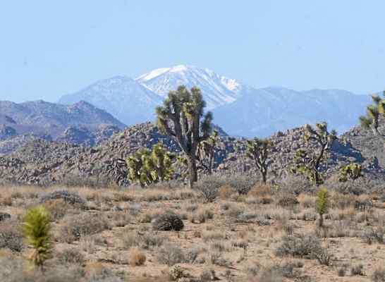
Southern California´s tallest peak, San Gorgonio Mountain, can be seen from some parts of Joshua Tree National Park. (Staff Photo by Sarah Alvarado/ San Bernardino Sun)

By Jim Steinberg
The San Bernardino Sun


TWENTYNINE PALMS -- Joshua Tree National Park, the nation’s 15th largest, is poised to grow by more than 20,000 acres early next year.

After a lengthy study and environmental assessment, the National Park Service recommends adding more than 20,000 acres of federal, state and private lands to the boundary of Joshua Tree National Park.

The majority of the land — all of it in Riverside County — is in the Colorado Desert, a low elevation and area too hot with too little rain for the park’s iconic plant, the Joshua tree.

This land, which includes the Eagle Mountain and Chuckwalla Valley areas, is of vital importance for the bighorn sheep and desert tortoise populations, a National Park Service statement said.

The area also includes prehistoric and historic resources that expand on the national park’s cultural themes and contains areas important for maintaining Joshua Tree’s wilderness values, the statement said.

The earliest this addition to Joshua Tree National Park could occur is in late February, said David Smith, park superintendent.

Originally, the land was included in the creation of Joshua Tree National Monument by President Franklin D. Roosevelt in 1936, but removed for mineral extraction activities in 1950.

During its mining heyday, iron ore was sent by train from the Eagle Mountain area to the Kaiser Fontana steel mill, where much of the finished product traveled by rail to shipbuilding activities in the Port of Long Beach, Smith said.

Major mining activities ceased in the area in 1983, the Park Service said in a statement.

In 1989, the area was proposed for a landfill. After decades of litigation, the landfill proposal was withdrawn in 2012.

The Park Service and federal Bureau of Land Management, which now administers most of the land, will evaluate public comments on the proposed transfer of the land from the bureau to the Park Service.

If the Department of the Interior determines that it is appropriate to proceed with the transfer, then it will authorize the publication of a public land order in the Federal Register.

A public hearing to discuss these proposed actions will be held from 6 to 9 p.m. Jan. 18 on the UC Riverside Palm Desert campus, Smith said.

Adding this land to Joshua Tree National Park also could be accomplished through congressional Action, Smith said.

February 5, 2016

Obama eyes remote corner of Mojave for desert monument

The Castle Peaks got their name because they resemble the ramparts of a castle. (Jay Calderon / The Desert Sun)

Sammy Roth
The Desert Sun


If you've never explored the Mojave Desert, the Castle Mountains wouldn't be a bad place to start.

Getting there isn't easy. From the Coachella Valley, the shortest route winds through the High Desert, east on Highway 62 and north through the Mojave National Preserve (the so-called "Las Vegas shortcut"), then east again past Nipton, a tiny railroad boomtown that's currently being sold for $5 million. The last leg of the trip runs through Nevada, crossing the state line near Searchlight before cutting back into California, via a series of rugged dirt roads that culminate in the Castle Mountains.

It's not a journey for the casual day-tripper. But once you get there...

The most stunning feature is the Castle Peaks, a series of jutting mountains that look like the ramparts of a castle. They loom large over the area's cholla cacti, creosote bushes and bighorn sheep. Baby Joshua trees shoot up from nurturing brush, even as their cousins in Joshua Tree National Park struggle to reproduce amid a changing climate. Abundant grasses and other verdant plants rise from the desert floor, providing so much ground cover that parts of the Castle Mountains look as much like a prairie as a desert.

​There's a ghost town, too, left over from a gold-mining boom in the early 1900s. But we'll get to that.

David Lamfrom, who works to protect California's deserts with the National Parks Conservation Association, guesses he's been to the Castle Mountains 50 or 60 times. Just a few hundred people visit each year, by his estimate.

“It’s just so freaking beautiful. It’s just a really unique place," Lamfrom said on a recent visit. "I’ve spent a tremendous amount of my time and energy and effort on the conservation of the Castle Mountains, even though there are a lot of places that really need and deserve protection.”

For the Castle Mountains, protection might come soon: Conservationists have urged President Barack Obama to declare the area a national monument, along with two larger sections of the desert. They expect Obama to grant their request within the next few weeks, creating the Mojave Trails, Sand to Snow and Castle Mountains monuments through his authority under the 1906 Antiquities Act.

Republican politicians, mining interests and off-road vehicle enthusiasts will cry foul if Obama invokes the Antiquities Act, even though most of them support legislative efforts to protect those areas from rampant development. And even if Obama does take action, the Castle Mountains wouldn't completely avoid industrial activity: A Canadian company calledNewCastle Gold hopes to reopen a mine that shuttered in 2001 due to low gold prices, and it has every legal right to do so.

Whatever happens next, there's little disagreement the Castle Mountains deserve some kind of protection. Just ask off-roader Randy Banis, who opposes a presidential designation but has worked with Sen. Dianne Feinstein to establish desert monuments through legislation. Asked about the Castle Mountains, Banis could barely contain himself: "Isn’t it incredible? Isn’t it absolutely incredible?"

"The vegetative diversity, and the health of the vegetation — I love stopping the vehicle and just stepping out and walking through," he said. "People are like, 'Really, this is a desert?' It’s just so beautiful.”

The Castle Mountains occupy an unusual perch in the vast Mojave Desert.

About an hour's drive from Las Vegas, the area is surrounded on three sides by the Mojave National Preserve; the fourth side is the Nevada border. If not for the gold mine, it would have been included in the California Desert Protection Act of 1994, which created the national preserve, along with Joshua Tree and Death Valley national parks. Feinstein, who wrote that bill, cut 29,000 acres out of the proposed preserve, giving then-mine owner Viceroy Gold Corporation plenty of room to maneuver on its 7,500 acres.

By the late 2000s, the mine was closed, and energy companies were eager to build solar and wind farms across the desert. Against that backdrop — which alarmed conservationists — Feinstein wrote a bill to protect 1.6 million additional acres, mostly by establishing the Mojave Trails and Sand to Snow monuments. The Castle Mountains would have been added to the Mojave National Preserve.

But the bill failed to get traction in a gridlocked Congress, as did similar proposals in 2011 and 2015. So last summer, Feinstein and conservation groups started urging Obama to protect those areas via the Antiquities Act, which he'd already used to create or expand 19 national monuments, including the San Gabriel Mountains National Monument in Southern California.

“The current political climate is making it difficult to move any lands legislation through either body of the Congress,” Feinstein said in October, at a public meeting that drew more than 1,000 people to the Whitewater Preserve to discuss the monument proposals. “My intention is to continue to push the bill, while simultaneously pushing a presidential designation. But let me be clear: My preference is very much to push the legislation.”

Monument status would preclude industrial development, from wind and solar farms to new mining. The designations would also bring new funding from the federal government, Lamfrom said, which in the Castle Mountains' case could be used to study unique plants and animals, survey Native American petroglyphs, develop a trails system and craft an interpretive plan to teach visitors about the area's history. The National Park Service would begin promoting the monuments, too, almost certainly boosting tourism.

The battle to preserve Castle Mountains

Desert gold

The proposed Mojave Trails and Sand to Snow monuments have commanded the most attention, since they're larger and closer to population centers. The Castle Mountains monument would be relatively small, and far from any California cities.

But conservationists say the Castle Mountains are just as deserving of protection — and not just because they offer stunning views.

Because of the area's unique geography — it's further east, and higher in elevation, than most of the Mojave Desert — the Castle Mountains foster a diversity of plant and animal life unmatched almost anywhere else in the desert. Monsoonal summer rains tied to the nearby Colorado River are particularly important, supporting dozens of species of grass that blanket the desert floor.

"It’s an extension of southwestern grasslands which extend from Texas all the way into California. This is typical of summer rainfall deserts," said Jim André, a botanist who runs UC Riverside's Sweeney Granite Mountains Desert Research Center, located in the heart of the Mojave National Preserve. “Most Californians don’t think of California as receiving the monsoon, but in far eastern San Bernardino County it’s quite prominent."

The area is also part of the world's largest Joshua tree forest, which stretches from Mojave National Preserve into Nevada's Lake Mead National Recreation Area. And unlike in Joshua Tree National Park — where the namesake species is struggling to adapt to global warming — Joshua trees are thriving in the Castle Mountains. It's not hard to find healthy Joshua trees sprouting up from black brush, which serves as a spiky nursery to the young plants, warding off herbivores until they can fend for themselves.

The area's relatively high elevations make that possible, providing lower nighttime temperatures than the low-lying national park can.

"Oftentimes when people think of deserts, they think of sand dune systems, or they think of lonely, flat places," Lamfrom said. "But this is a rugged, beautiful mountain-scape filled with Joshua tree forests, with piñon, with juniper, with native grasslands...this is really, I think, one of the truly unique and remarkable places in our desert."

Unbroken wilderness

The same factors that give rise to the Castle Mountains' diverse plant life also support abundant wildlife. It would be difficult to list all of the creatures that spend time there: desert tortoises, bighorn sheep, Mojave ground squirrels, mule deer, mountain lions, Cooper's hawks, great horned owls and more. Several of those species are protected under the state or federal Endangered Species Acts.

Keeping the Castle Mountains pristine, conservationists say, is bigger than just giving those species another place to live. They see the Castle Mountains as a critical link in a chain of largely undisturbed desert that stretches from the Mojave National Preserve into Nevada, eventually connecting the 1.6-million-acre preserve with the 1.5-million-acre Lake Mead National Recreation Area.

Keeping that chain intact is especially important for species like bighorn sheep, which roam the open desert. As cities, freeways and fences have increasingly crisscrossed what once was wilderness, bighorn sheep populations have fallen dramatically.

"You can’t keep them in isolation. You have to allow those connections to other (bighorn sheep) populations, so they can have genetic exchange," said Dennis Schramm, who served five years as superintendent of the Mojave National Preserve. "If you don’t protect it, and you put in more fences and windmills and solar fields and all those kinds of things, you’re chopping up the habitat."

The Castle Mountains could also provide habitat for a new species.

A century ago, pronghorns — the world's second-fast land animal, after cheetahs — thrived in the deserts of Southern California. But humans hunted the antelope-like species, and eventually it disappeared from the region.

For years, the National Park Service and state wildlife officials have wanted to reintroduce pronghorns in the Castle Mountains. But they've been waiting to take that step until the area receives stronger protection, which would help ensure their efforts won't be in vain.

Gold in the hills

More than 100 years ago, the Castle Mountains were better known for gold than they were for flora and fauna.

Three Nevada prospectors — Jim Hart, and the brothers Bert and Clark Hitt — struck gold there in December 1907, and by the next year a mining town known as Hart was thriving. The town had about 400 residents, along with five hotels and eight saloons, according to a plaque that greets visitors today. Lamfrom said he's heard the town had two brothels, although that isn't mentioned on the plaque.

Miners quickly realized there wasn't much gold that could be economically extracted, and within a decade the town was deserted. The buildings are gone, but remnants of Hart are still visible: Rusted metal cans litter the base of the gold-laden hills that give the Castle Mountains their name. Viceroy opened a new mine in 1992, although that one, too, lasted less than 10 years.

"The Western American history of this landscape has been intimately tied to mining, and the ability for the (National) Park Service to tell the story of mining here is really important," Lamfrom said.

Mining could also play a role in the Castle Mountains' future.

NewCastle, which bought the mining rights in 2012, estimates there are at least 4.2 million ounces of gold in the hills, which would yield nearly $5 billion at today's prices. A new mine could employ a few hundred people, said Marty Tunney, NewCastle's vice president for business development. The company is still conducting preliminary studies, and could be several years from opening a mine.

NewCastle's permit will expire in 2025, although it could ask San Bernardino County for an extension if there's enough gold to justify further mining. In the long term, the company hopes to give the land to the National Park Service, Tunney said.

"If we were able to mine it the way we would like to go and mine it, and extract the value of it, we’d like to go through full reclamation and hand the project over to the (Mojave National) Preserve," he said. "We currently don’t see any reason why that shouldn’t happen."

Tricky politics

The proposed Mojave Trails monument has generated more controversy than Sand to Snow or the Castle Mountains. Feinstein's bill would ban new mining claims across the monument's 942,000 acres, which surround historic Route 66, between the Mojave National Preserve and Joshua Tree National Park. Big mining companies support the bill, but a cadre of smaller firms fiercely oppose it.

Rep. Paul Cook, a Yucca Valley Republican who represents the High Desert, has put forward a different proposal. His legislation, like Feinstein's, would create the 140,000-acre Sand to Snow national monument, stretching from the desert floor near Joshua Tree National Park to the peak of Mount San Gorgonio in the San Bernardino National Forest. But it would offer a lesser level of protection to the Mojave Trails, establishing a "special management area." Ten percent of that area would be open to new mining operations.

At the public meeting in October, John Sobel, Cook’s chief of staff, expressed hope that his boss and Feinstein could compromise. He criticized calls for Obama to use the Antiquities Act, saying a presidential designation would create “second-rate monuments because they lack the adequate support of locals and of Congress.”

Banis, who represents the California Off-Road Vehicle Association, supports Feinstein's bill, since it would keep the Mojave Trails monument open to off-roaders. He's worried a presidential designation would ultimately lead to the closure of the area's dirt roads.

“Boy, it’s going to get me mad if they name this thing the Mojave Trails, and then they go and close the roads. I’ll be so ticked off," Banis said. "That would be such a slap in the face to the recreation community.”

The Castle Mountains are less contentious. While Feinstein and Cook's bills would add the area to the Mojave National Preserve — an option that isn't available through the Antiquities Act — conservationists say a monument designation would have the same effect.

Cook disagrees. He said in an email that a presidential designation could "seriously jeopardize the existing mine by including land needed for mining operations, as well as limiting the ability to drill for wells to supply water needed for operation." He also said adding the area to the preserve would make more sense, from a management perspective, than creating a standalone monument.

"I view a Castle Mountain monument designation as a stealth attempt to shut down one of the most important mineral projects in the country," Cook said in an email.

NewCastle isn't so concerned. Company officials prefer Feinstein and Cook's bills to a presidential designation, since they know the bills would protect their ability to mine. But the company doesn't oppose the Antiquities Act route, so long as Obama includes similar protections for mining. Tunney, NewCastle's vice president for business development, said the company has been "given some assurances by Sen. Feinstein's group" that Obama's Castle Mountains designation would look similar to the provisions in her bill.

"If that’s the case, that works for us," Tunney said.

January 12, 2016

Strange Amargosa River creates series of Mojave oases

The Amargosa River winds its way through a canyon near China Ranch Date Farm on its way to Death Valley. (Las Vegas Review-Journal file photo)

By Margo Bartlett Pesek
Las Vegas Review-Journal


The Amargosa River, a strange desert stream that runs mostly underground, meanders 185 miles through the Mojave Desert. Starting in the hills near Beatty, it courses south and loops north to end up in California at Badwater in Death Valley National Park, only about 50 miles from where it began.

Where the river runs on the desert surface, it creates a series of oases with running water, wetlands, lush vegetation, even a waterfall in Amargosa Canyon, a protected 26-mile section between Shoshone, Calif., and Dumont Dunes Off-Highway Vehicle Recreation Area.

Set aside by law in 2009, the portion of the river through Amargosa Canyon is listed as one of America's Wild and Scenic Rivers. It is considered an area of critical environmental concern because of several species of endangered animals and plants found nowhere else. Administered by the Bureau of Land Management as the Amargosa River Natural Area, the canyon is open to public use for a wide variety of recreational pursuits compatible with species protection aims.

Off-highway driving is restricted to the high sand mountains and extensive sand seas that make up the Dumont Dunes south of the protected area. This attraction draws crowds of enthusiasts during cool-season weekends and holidays. The nearby Amargosa River Natural Area and other public lands are closed to off-roaders. Motorized vehicles must stay on roads and trails marked for their use. There are many miles of paved and unpaved tracks open to scenic touring and exploration in the area.

To reach the region from Las Vegas, head south on Interstate 15 to state Route 160, the road to Pahrump Valley. Watch for the turnoff from Route 160 onto the Old Spanish Trail Highway toward Tecopa and Shoshone, named for the famous overland route between Santa Fe, N.M., and Los Angeles used during the 1800s. You can also continue to Pahrump and turn on state Route 178 to reach Shoshone at the junction with state Route 129, then turn south to reach Tecopa. Some travelers continue south on I-15 to Baker, Calif., then turn north on state Route 129 toward Shoshone, a route often preferred by off-roaders heading for Dumont Dunes.

Humans have been living in and traveling through the Amargosa area for thousands of years. Visitors today see signs of their passing in occasional petroglyphs, grinding holes pockmarking stone in traditional camping areas, scattered rock chips from making stone points and tools and roasting pits where food was cooked in the ground. Early hunters and gatherers followed the water to find game and the natural foods that grew along the ancient stream. The Amargosa River has been cutting its way through ancient layers of stone in this area for a long time as it carved its deep little canyon.

The plants, birds and animals remain attractions drawing humans to this area, but today they come to watch, admire and photograph the creatures drawn to the oasis. Visitors walk, hike, climb, ride horses and mountain bike along trails in the area. At least 250 kinds of birds have been sighted, both residents and migrants. Many rabbits, rodents and other small creatures live there. Nighttime brings out myriad stars, several kinds of bats and nocturnal hunters such as owls, coyotes, foxes and bobcats.

The old grade of the long-defunct Tonopah and Tidewater Railroad now provides pathways to points of interest along the river, including the 6-mile Amargosa River Trail with its trailhead at China Ranch, a date farm in a side canyon south of Tecopa Hot Springs off Furnace Creek Road.

Ask at China Ranch how to reach the 4-mile round-trip Slot Canyon Trail. Allow yourself time to sample the baked goods, dates, gifts and milkshakes at China Ranch.

The Grimshaw Lake Watchable Wildlife site is near the old railroad grade, about a mile along a dirt road west of the highway halfway between Tecopa Hot Springs and the community of Tecopa. Private and public bathhouses and resorts are a draw at the hot springs. Details for hikers, climbers and rockhounds can be found at blm.gov/barstow/amargosa.

January 5, 2016

How Ancient Native American Rock Art Is Tearing a California Town Apart

A display at the Petroglyph Festival that many Native Americans find disrespectful

By Barret Baumgart
VICE Media


I

At 1.2 million acres, Naval Air Weapons Station China Lake is the largest parcel of land owned by the US Navy. It fills an expanse of remote and rugged desert terrain bigger than Rhode Island; to the naked eye, there's not much going on inside. You might spend a whole day driving around the perimeter of the base and, notwithstanding an occasional low-flying F-16 fighter jet, never guess there was anything outside your window beyond barren volcanic tablelands, stands of brittle burrobush, and the occasional sidewinder rattlesnake.

What makes NAWS China Lake special—beyond being a secret test center for the world's most advanced weapons—is that inside a handful of its narrow lava canyons lies the largest concentration of Native American rock art in the Western Hemisphere. The images, carvings known as petroglyphs, are found throughout China Lake's Coso Range and are the oldest in the Americas. Archeologists have dated some of the images as far back as 15,000 to 19,000 years, and nobody has ever successfully counted them. A single canyon—Renegade Canyon, or as it's more commonly called, Little Petroglyph Canyon—may contain more than 1 million images of bighorn sheep, shamans, and abstract geometric symbols.

While archeologists have argued over the function of these and other figures for half a century, their original meanings largely remain a mystery. What nobody contests, however, is that the Coso Range was once one of the most spiritually important sites on the continent.

Some New Age types consider the Coso Range a "vortex"—a geographic location where harmonizing spiritual energy is supposedly highly concentrated. Examples of such places apparently include the Pyramids at Giza, Stonehenge, and the red rocks of Sedona, Arizona. Even if you don't put stock in such dubious concepts, being in the presence of such ancient and sacred symbols can be a powerful—and humbling—experience.

For decades, however, their location inside a military base dedicated to top-secret weapons testing meant that the only people who knew—or cared—about the petroglyphs were a handful of Native American tribes, professional archaeologists, and a subculture of Indian art geeks and New Age vision seekers. But Ridgecrest, California—the small desert town just outside the main gates of China Lake—is attempting to change that, and turn the petroglyphs into a full-fledged international tourist destination.

This effort has created a clash between competing economic and cultural interests. For many members of the Native American tribes throughout the region, the Coso Range and its petroglyphs are the most sacred things in the world, but some say that the sanctity and very survival of the artwork is threatened by Ridgecrest's attempt to cash in on the petroglyphs and sell itself as "California's newest cultural mecca"—the Petroglyph Capital of the World.

II

In 2014, Ridgecrest's then-mayor Dan Clark proposed an entire festival centered around the petroglyphs, describing it as a potential "economic engine" for the city of Ridgecrest. "The petroglyph festival will be our signature event," he told the LA Times. "We're going to saturate this community with representations of rock art." Denny Kline, a field officer for Mick Gleason, Kern County's District 1 Supervisor, told reporters, "It's going to be the city's 50th anniversary on steroids." Sponsors for the four-day festival included Coca-Cola, General Electric, NASA, the Ford Foundation, McDonald's, and Home Depot, among others.

A year later, the town remains committed to becoming the "American 'Machu Picchu,'" as a recent press release proclaimed. That release quoted Doug Lueck, the executive director of the Ridgecrest Area Convention and Visitor's Bureau (RACVB), as saying, "Not only is tourism up, we're also experiencing an upward trend in filming for movies and commercials as well." According to Leuck, the first annual Petroglyph Festival "had over 1,000 media impressions over television and radio" and sold out local hotels. Harris Brokke, the former director of Ridgecrest's Maturango Museum, told the local paper. "Not only is the festival successful, but when people come to the festival, they come back again and again, and that's our whole goal."

"Ridgecrest has tried to brand itself in a lot of different ways," a retired Navy veteran named Mike tells me. "There's no real tourism here. Most people either work on the base or the service industry that supports it."

We're standing in the parking lot of Ridgecrest's new $6 million tourist attraction, Petroglyph Park. House finches flit between palm trees and brown monoliths carved with depictions of bighorns, zigzags, and shamans; in the background traffic hums along China Lake Boulevard.

"The city tried the Balloon Festival two years in a row, but the winds were horrendous and just destroyed everything," Mike says. Ridgecrest also launched a spring Wildflower Festival, but given the reality of the California drought and the fact that Ridgecrest only gets a few inches of rain each year, the flowers didn't always show. "But the Petroglyph Festival is something that's uniquely Ridgecrest," Mike says.

Behind us, across the street, music booms from the stage at the center of the Balsam Street Fair, where 200 vendors have set up tents selling scented candles, foreign war memorabilia, and dreamcatchers made in China. It's the second annual Petroglyph Festival, a showcase for the best parts of the town held in November. Balsam Street functions as Ridgecrest's version of a downtown arts district. Elsewhere in the city, abandoned storefronts mingle with used furniture dealers; bail bonds shops sit in squat strip malls with asphalt that looks like it hasn't been repaved since the Vietnam War—but on Balsam Street you find a newly painted bighorn sheep or shaman on nearly every available wall. This is, without question, the Petroglyph Capital of the World.

The catch, however, is that historically it's been extremely difficult to see the actual petroglyphs of the Coso Range. According to the RACVB, 15,000 people traveled from over 50 countries for the 2014 Petroglyph Festival. But only around 40 American citizens who applied early and passed a federal background check were able to view the carvings inside the base. This year, though, an RACVB spokesperson tells me, the Navy had "agreed to forgo the vetting process" and let 500 people see the petroglyphs, including many non-Americans, who would normally be barred from entering the base at all.

Among them is a woman from Germany named Karin. She waited years for the opportunity to make a pilgrimage to the petroglyphs; during November's festival she finally did it. "Everything from the drive, the Joshua trees, the beauty of the mountains. The whole landscape was just magic. We saw wild horses," she tells me. "It's obvious why the petroglyphs are there." I ask if she learned anything. "Imagination," she replies. "Imagination is what you need."

Another woman, a Japanese citizen named Maiko, had been waiting nine years for the opportunity. "I'm actually a petroglyph freak. I go to all the sites. It's just attractive to me. I want to see the art. So I do the research on the internet. And then I go there and look for it."

Those whose love for petroglyphs burns less arduously make do with Petroglyph Park, where you can gaze at reproductions of the carvings and experience an Epcot version of the ancient etchings. City and county officials often emphasize the sacredness of the petroglyphs and the educational aspect of the attraction—"the concept of the park is to honor the Native American heritage of the Indian Wells Valley," says Denny Kline—or as Mayor Clark has said of the petroglyphs, "We can bring it to the public's attention what a national treasure they are and, hopefully, they will respect them."

But the park and the festival are unquestionably money-making affairs—the whole point is to draw in vendors and tourism dollars. And many aspects of the festival seem less interested in history and education than hustling and speculation.

I head over to the north end of Balsam Street, where Rod "The Buffalo Man" Blankenship—a Korean and Vietnam War Veteran, and "an Elder in the Cherokee Indian Nation"—is talking about the buffalo to a crowd inside the Old Town Theater. The animals were "a supermarket and hardware store," according to Blankenship, who punctuates his pronouncements with shakes of a ceremonial rattle made from dried buffalo scrotum. Toward the end of the talk, I raise my hand and ask him how important the buffalo was to the Native American tribes in the surrounding area, and he admits that the animals weren't out here in California. But maybe some of the petroglyphs depict buffalo?

"It's possible," he says. "You know what you'll see in some of those petroglyphs, though?" He pauses and seems to stare out above the audience, straight through the back of the auditorium at something unseen. "You'll see pictures of what you call,"—another pause—"aliens. They're pictures of space people. With big round heads. Oval heads."

Other lecturers in the festival's educational "Speakers' Series" include a local wilderness entrepreneur who runs private tours of petroglyph sites that aren't on Naval land—"If you're interested, we can talk prices later," he tells the audience—and an archeologist who also offers private tours. Both do so despite heavy discouragement by the federal Bureau of Land Management (BLM), which fears that if the locations of off-base petroglyph sites become widely known they'll be vandalized or stolen.

Outside the Old Town Theater, across Freedom Park, smoke billows up from the cookers stationed behind the Intertribal Powwow and Cherokee Hog Fry. The powwow has all the usual signifiers of Native American life: tepees, donkeys, women dressed in buckskin suits, men on folding chairs beating a large leather drum, vendors hawking dream catchers and geodes. The festival advertises the drummers, dancers, and vendors as members of the local Native American tribes, but the Cherokee have no ancestral ties to the land or the ancient peoples responsible for the petroglyphs.

"We didn't use tepees and we're not a powwow culture and we didn't eat pigs. They're teaching people that this is what the people looked like that were here," says Jonnie Benson, a member of the Lone Pine Paiute-Shoshone who adds that it's the "miseducation" of the community that is most upsetting. "They took a real touristy approach. Now we have all these people walking away after this weekend thinking, 'Oh, wow, I've learned all about the natives who live here,' when in fact they don't know shit. They learned the Hollywood story."

Down the street from the powwow sits another sore point for some local tribes: a plywood board painted with two shaman figures, their faces cutout to allow tourists to poke their heads through and smile for pictures.

"It's so offensive. Our ancestors put those marks on the rocks, whether people want to believe that or not. It's sacred to me, and to see it as basically a caricature, with people putting their faces in it—they don't know what those symbols mean," says Benson, who'd seen the pictures on Facebook. "I don't know how people would take it if there was a painting of Jesus up there and people were sticking their faces in it. Right? It just wouldn't be cool."

III

Though the Petroglyph Festival is based around the cheerful, corporate-ready commercialization of the Coso rock art, the petroglyphs themselves depict strange and often violent imagery. On nearly every cliff face of Renegade Canyon, you find not simply pictures of bighorn sheep, but bighorns etched in the throes of death, their bodies impaled with spears and torn by arrows.


The mood on petroglyph tours is, if not somber, generally one of quiet reverence. Tour guides do an especially good job just hanging back, allowing the art to sink into the group, and not pushing forth any interpretation. Though they do occasionally step in. I remember on my first tour of Renegade Canyon, a woman kept pointing out the strange round-headed humanoids carved in the walls, and saying, "Look, an alien wearing a space helmet," or, "Look, an alien with a cell phone."

"Archeologists call those 'patterned body anthropomorphs,'" a guide eventually told her, adding that the art was still sacred to the tribes throughout the region, and it was disrespectful to infantilize the art of their ancestors in such a way.

When the festival isn't happening, normal tours of Renegade Canyon, arranged through the Maturango Museum in Ridgecrest, take 20 people on select weekend dates determined by the military during the fall and spring months. The Navy makes you sign a form that releases them from responsibility should you break a leg or catch a stray bomb, and the background checks conducted by the military usually take two to three weeks. The tours cost $40 and nearly ever one sells out. Excluding the festival, only about 800 people make it in to see the art each year.

In many ways the tours seem like a routine trail walk. People park in a dusty lot, tightening their boots and backpacks while guides take a headcount. In the distance below, the black gash of Renegade Canyon cuts west across the wide desert terrace, its exit at the lower ridge too far off to see.

A trail winds out through the fragrant burrobush, sage, and creosote, out from the edge of the dirt lot to the rim of the canyon, where it drops down through a steep side wash. Below, bright lichens cover the brown walls of the canyon, but you can't see anything yet. Guides remind you to watch your step as gravel crunches underfoot. Sunlight burns against your back, painting your blue outlines as you file forward and the walls narrow and voices hush. A carpet of soft sand covers the canyon floor. Like children sneaking into some forbidden sanctuary, everyone keeps trading excited and worried glances, scanning for the first petroglyph—but there's only the vast silence of the canyon, impenetrable as the rock walls closing you in. You glance back. Faraway, along the eastern horizon, a pair of perfectly formed volcanic domes lay like soft breasts tanning in the morning sun.

Then, without a word, the digital camera shutters start clicking. Up ahead, a dozen people stand aiming at the rock wall, while others crouch and kneel, jostling for position. Five pale shoe-sized sheep engravings cover the dark basalt. Geometric designs wrap around the periphery. A man crawls up for a closeup and one of the guides tells him that it's close enough: "Everyone, please keep back at least two feet from the petroglyphs." People keep vying for position, standing on their toes with cameras raised, as though the tiny darting sheep were actually alive, actually running away, fleeing the hungry tourist photographs.

Just minutes later, this initial flurry of photography seems absurd. The canyon contains more petroglyphs than any camera eye or human memory can record. By the time most people reach the cliff at the end of the canyon, they've stopped taking pictures, stopped talking altogether—they just sit and stare off into the expanse below.

The cumulative effect of the canyon is hard to describe. It's not something you can get from simply looking at a few panels of petroglyphs. You have to spend the whole day walking the canyon's entire length to let the images wash over you. Not everyone who takes the tour hikes the mile and a half down to the end—some people only go halfway and then return to the shaded picnic table beside the parking lot. You cannot get this cumulative effect if you turn back. Nor can you get it from other petroglyph sites off base or the tours during the Petroglyph Festival, which only spend an hour at the canyon's entrance.

Everyone's experience differs, I'm sure. For me, an initial impression, if there ever was one, that the petroglyphs resembled something inspirational or alien faded away the further I walked down the canyon. It was replaced by a sense of awe at the sheer number of etchings, which in turn gave rise to a sensation of mild dread when I realized that they all mostly depict the same image—bighorn sheep.

And as you continue to wander down the length of the narrow lava canyon, despite the open sky, the clean desert light, and the quiet conversation of the people around you, a feeling of claustrophobia begins to assert itself. And the further you venture, the more the canyon narrows, and the more pictures you pass, the deeper this feeling extends, until you come to understand that you've entered a place that is not your home, gawked at pictures not made for your enjoyment, photographed panels of bighorn sheep never made for pleasure but rather in pain, ripped out from the walls by desperate men with bloody fingers over so many lonely millennia, and once you reach the end of the canyon and see how many times that single intentional image occurred, a final conclusion presents itself: Something went wrong here.

IV

No one knows for certain what the rocks record. But they have been perfectly preserved thanks to airtight military security. Even the tribes who revere the rock art of the Cosos have to jump through hoops to pay their respects.

"The sites still have their power but we can't use them properly; we have to be escorted and they watch us down at the hot springs and it's very irritating," says Kathy Bancroft, the Cultural Officer for the Lone Pine Paiute-Shoshone.

"At this point in the journey," says Jodie Benson, "I'm just grateful that the art is out there on Navy land, and not just anybody can go out there."

Not all the petroglyphs are on land protected by the military, however, and as the art has become more famous, Native Americans and archaeologists worry about people damaging other unprotected sites or stealing the petroglyphs right off the walls. The worst case of vandalism occurred not long before the first annual Ridgecrest Petroglyph Festival, in an area north of the Cosos. In a matter of hours, looters wielding power saws, electric generators, and ladders managed to steal a handful of petroglyphs that had survived thousands of years of natural erosion.

"Anybody could have driven out on top of them, there would have been a dust cloud," Greg Haverstock, an archaeologist at the Bureau of Land Management, tells me. "These people were extremely bold." The event was the worst case of vandalism ever seen on the nearly 1 million acres of public land managed by Haverstock's BLM office.

Though multiple people I talked to say that cases of vandalism were on the rise, there was some disagreement about the cause. Donald Storm, another BLM archaeologist, says that China Lake's severely restricted access is a problem—if people can't enter the base they might go looking for petroglyphs on unprotected land. "If they're out in the public domain, damage is more likely because these sites are hard to control," he says.

Bob Robinson, the Tribal Historic Preservation Officer of the Kern Valley Indian Council, thinks that the festival is not helping to reduce the destruction. "As it is we have enough problems with sites being vandalized without all the promotion of the festival." Robinson says that tourists need to know that the petroglyphs are not doodles on rocks, but put there for a reason, and they're part of a living ongoing culture that is here today: "People need to understand that they're sacred and they need to be treated with respect." According to Robinson, this is the "education part that I hope will be there at the festival, and not this thing of creating this whole New Age story around aliens putting them there."

But Robinson isn't very optimistic. He describes the festival as "commercial exploitation. They're turning it into a Roswell bullshit."

This, ultimately, is the dividing line between Ridgecrest and some local Native Americans, who see the festival not just as a commercialization of their culture but something that could literally fuel the destruction of their sacred symbols.

"The worst thing about it is the town of Ridgecrest," says Kathy Bancroft. "They want to be the petroglyph capital of the world. I heard that on the local radio station and I thought, Who said they should do that? " Bancroft says it's incredibly disrespectful for the festival to be promoting the petroglyphs with vandalism on the rise.

On this point, everyone agrees: Protecting the petroglyphs is the most important thing. "The only way that the petroglyphs will continue to be here for a very long time is by protecting them and respecting them," says Debbie Benson, the current director of the Maturango Museum, which organizes tours of Renegade Canyon. "Not all petroglyphs are on the base. If people are harming them and don't understand them and not respecting them, they will not last."

Some of the materials in Petroglyph Park are of dubious educational value, however. One large engraving near the entrance is entirely unlike any of the actual petroglyphs; when I asked archaeologists about it they said they had never laid eyes anything like it. "I can honestly say I've never seen an image in rock art that resembled that even closely," Greg Haverstock said. "I look at that and I think 1950s sci-fi aliens."

The particular stand of petroglyphs is labeled "Shamanic Visions or Alien Visitors." The placard in front of it pays lip service to the popular New Age concept—promoted by Erich von Däniken's 1967 bestseller Chariots of the Gods—that many rock art images throughout the world portray aliens who visited earth, planted the seeds of consciousness in primitive humanity, and made possible all the cultural achievements of ancient man. This notion has been criticized for minimizing the actual artistic achievements of indigenous people and for simply being shoddy history. "That writing as careless as von Däniken's," Carl Sagan wrote in 1976, "whose principal thesis is that our ancestors were dummies, should be so popular is a sober commentary on the credulousness and despair of our times."

V

As it stands now, the tribes have no interest in participating in the Petroglyph Festival. None of the Native Americans I spoke to had ever attended it, and some, like Bob Robinson, openly condemned it. "They're just cashing in on something sacred. They're selling it. And I don't want any part," he says. "We don't want to participate because of the money."

Kathy Bancroft says that Ridgecrest never even approached her tribe about the festival. All they did was send advertisements. "If I really felt they cared and wanted to do it right maybe I'd participate," Bancroft says. "They've taken something sacred and spiritual and created a stereotype, a team mascot for the city of Ridgecrest, and it makes me sick."

Some Native Americans I spoke with emphasize that a festival that educated the public about the petroglyphs could be beneficial, if it made people more aware of the sacred nature of the rock carvings and the history behind them. Barbara Dutton, a member of the Death Valley Timbisha-Shoshone, tells me the festival was "a good opportunity for educating the general public about how important these sites are to the native people." But Dutton did admit, "I don't know what kind of information they have out there."

Given the information I encountered there, the Petroglyph Festival appears to have little interest in educating the public about the sacred nature of the rock art or the history behind it—which is truly a shame.

The petroglyphs at China Lake can be interpreted many ways. I prefer an explanation offered by archeologist David Whitley, who thinks that the Coso Range was once the central pilgrimage point for rainmaking shaman throughout the Great Basin.

"The images should not be interpreted in a literal sense," Whitley says. The petroglyphs represent not literal hunting scenes but rather "graphic expressions of the visions of rain shamans that, themselves, were metaphors for the rain shaman's supernatural control over the weather." The images of mutilated bighorns represent prayers for rain, not bighorns, according to Whitley.

As anyone who has lived through California's ongoing drought knows, we still pray for rain, though we do it in different ways. It was in China Lake where the military crafted the rain-making technology of "cloud seeding," which was deployed during the Vietnam War in an attempt to flood the Ho Chi Minh Trail. Today the technique, which involves shooting particles into clouds to form ice crystals, is used across the American West, including California, to ward off drought. It isn't clear, however, that cloud seeding is any better at bringing rain than carving bighorns into the sides of rocks.

If you go to the Ridgecrest Petroglyph Festival, or if you visit the rock art of the Coso Range, don't approach the art lightly. Don't dismiss its creators as being primitive, or assume they needed to be influenced by UFOs in order to make their art. Think about their world, plagued with uncertainty, their struggles to scratch out lives against the harshness of the Mojave Desert. And think about the uncertainties of our own world today—the reality of global climate change and a perpetual war on terror. Remember that at China Lake, while the military continues to protect the traces of past man, in the same breath, in the same location, they continue to perfect the art of erasing him from the present.

And if you have a chance, take a look some of the most impressive petroglyphs, the rare ones depicting the skinny men riding strange animals, the white men arriving—the aliens. Ask yourself: Who will last longer—us or the petroglyphs?

January 31, 2013

Acting on tip, federal officials recover stolen petroglyph panels

The location of the petroglyphs, stolen from a sacred Native American site last fall, was disclosed in an anonymous letter. The tip may have come from the thieves themselves.

Greg Haverstock, an archaeologist with the U.S. Bureau of Land Management, inspects the site north of Bishop, Calif., where thieves removed Native American petroglyph panels last November. Aciting on a tip that may have come from the thieves themselves, federal authorities have recovered the five panels. (Don Kelsen, Los Angeles Times / November 12, 2012)

By Louis Sahagun
Los Angeles Times


Federal investigators acting on a tip have recovered five petroglyph panels that thieves cut from an eastern Sierra site sacred to Native Americans, U.S. Bureau of Land Management officials said Thursday.

The location of the petroglyphs, stolen last fall, was disclosed in an anonymous letter to authorities.

By failing to sign the letter, its author walked away from a $9,000 reward — a sign that the tip may have come from the thieves themselves. Experts had said the petroglyphs would fetch little money from collectors and would be difficult to fence because of widespread publicity about the theft.

No arrests have been made and the investigation is continuing, officials said.

Bernadette Lovato, manager of the BLM field office in Bishop, declined to disclose details about the recovery, including when or where the petroglyphs were found. "The panels are currently being held as evidence," Lovato said.

"Now, the healing can begin," she said. "Recovery was a priority for me, and the public outrage intensified the need for them to be returned."

Investigators believe the vandals used ladders, chisels, electric generators and power saws to remove the panels from cliffs in an arid high-desert region known as Volcanic Tableland, about 15 miles north of Bishop. The thieves gouged holes in the rock and sheared off slabs that were up to 15 feet above ground and 2 feet high and wide.

The theft was reported to the BLM last Oct. 31 by visitors to the area, where Native Americans had carved hundreds of lava boulders and cliffs with spiritual renderings: concentric circles, deer, rattlesnakes, bighorn sheep and hunters with bows and arrows.

The site, which is still used by the local Paiute Indians for ceremonies, is protected under the Archaeological Resources Protection Act and is listed in the National Register of Historic Places. Authorities said the petroglyphs were probably worth no more than $500 to $1,500 each.

But they are priceless to Native Americans, who regard the massive tableaux as a window into the souls of their ancestors.

"It feels real good to have them come back home," said Raymond Andrews, Paiute tribal historic preservation officer.

Lovato said the petroglyphs may eventually be put on public display, "but that will be up to Paiute-Shoshone tribal leaders."

Damaging or removing the petroglyphs is a felony. First-time offenders can be imprisoned for up to one year and fined as much as $20,000, authorities said.

Anybody with information about the theft is asked to contact the BLM at (760) 937-0301 or (760) 937-0657.

January 1, 2013

BLM agents continue to investigate petroglyph crimes

An area where the thieves tried to carve out a petroglyph
but ended up leaving it. (Bureau of Land Management)
by Benett Kessler
Sierra Wave Online


Bureau of Land Management investigators continue to look into the case of the stolen and damaged petroglyphs near Bishop. A month ago, BLM reported that someone had used a power saw, generators and ladders to cut out and take at least four petroglyphs, leaving dozens of others damaged. The news went global.

One of the BLM agents working on the case is Melody Stehwein. She said in the new year the investigation is still ongoing. She said donations are still being made and that the $2,000 reward for information in the case has gone up. She said the climbing community, for one, had contributed to the fund.

Stehwein said she could not report any new details on the case. Anyone with information on the case that would lead to the thieves is asked to call investigator Eric Keefer at 760-937-0657 or Melody Stehwein at 760-937-0301.

Greg Haverstock, BLM Archaeologist, confirmed that the rock art is thousands of years old and part of the current Paiute Tribe’s ceremonial tradition. Haverstock said Europeans documented the rock art prior to 1890 and geological evidence shows them to be thousands of years old. Haverstock had earlier said, “The location of archaeological materials, feature remains and the rock art clearly portray the activities that occurred at the site during the past 3,500 years.”

February 1, 2012

Museum plans events for Arizona Centennial

COLORADO RIVER MUSEUM: The Colorado River Historical Society and Museum, between the Laughlin Bridge and Davis Camp, is planning two days of events for local celebration of the Arizona Centennial.

By JAMES CHILTON
The Daily News


BULLHEAD CITY — With the Arizona Centennial less than two weeks away, the Colorado River Historical Society and Museum is preparing two days’ worth of events for the public to enjoy.

Museum president Dave McDaniel said the society has been hard at work on creating an interactive pathway around the museum grounds that will provide snippets of history from Arizona’s century of statehood. The path will include items that hearken back to the area’s history, with numbered markers that correspond to a brochure visitors can reference to read about Bullhead City’s past, from the first Native American settlers, to the Colorado riverboat days of the mid-19th century, to the founding of Hardyville, the area’s original white settlement.

“The new pathway that runs around the museum is going to be designated the Arizona Centennial Pathway, and along the pathway we’re going to have little snapshots of history,” McDaniel said. “Along each stop there are numbers, and in the brochure, they give information about Hardyville, steamboats in the area, the Beale Wagon Road, and we have a mural that was painted by Paul Jackson, who is the tribal artist for the Mojaves.”

Inside the museum, McDaniel said, visitors will find both current and historical maps of the state dating back to 1912, as well as some other artifacts that are indicative of local life during the early part of the last century.

“On Feb. 11, we’re going to have an open house from 11 in the morning until 2, and the city council’s and some of the Fort Mojave tribal members are invited,” McDaniel added. “And we’re going to have some souvenirs we’re going to give out. We’re going to have coin envelopes with wheat pennies in them that mention the Colorado River Museum and the ‘cent’ennial.”

Then at 1 p.m. on the Feb. 11, McDaniel said the museum will host a going-away celebration in honor of Bullhead City’s first elected mayor, J. Michael “Mike” Love, who will be departing to Sacramento, Calif., with his wife Gloria after spending the last 32 years here. On Wednesday, Love dropped by the Bullhead City Hall, where he bid his formal good-byes to current mayor Jack Hakim and City Manager Toby Cotter, receiving a certificate of appreciation and the key to the city for his service.

Following the open house, on the day of the actual centennial, Feb. 14, McDaniel said the museum is planning a host of programs for the day, running from 9 a.m. to 2 p.m. The programs will include presentations on a number of subjects including Hardyville and Original Bullhead, as well as a video presentation on the steamboats of the Colorado River and a hike to “Museum Rock,” a nearby Indian petroglyph.

The museum’s regular hours of operation are from 10 a.m. to 4 p.m. Tuesday through Saturday. For more information, or a full schedule of centennial events, call 928-758-7643 or 928-754-3399.

October 30, 2009

945,000 acres protected from mining for 20 years

Federal agency withdraws critical environment in Southern Nevada


Petroglyphs are shown in the Sloan Canyon National Conservation Area. The area is part of 945,000 acres in Southern Nevada that the Bureau of Land Management is protecting from new mining activity in Southern Nevada for 20 years. (Mona Shield Payne/Special to the Sun / File photo)

By Mary Manning
Las Vegas Sun


The Bureau of Land Management signed an order today that withdraws almost 945,000 acres of sensitive public lands from new mining activity in Southern Nevada for 20 years.

The bureau said it had taken the action to protect 24 areas of critical environmental concern in Clark and Nye counties. Existing mining and geothermal claims will not be affected, the order said.

The sensitive areas include cultural sites, such as petroglyphs and archaeological sites, and wildlife habitat that is crucial for survival of the Mojave Desert tortoise, the southwestern willow flycatcher bird, woundfin and Virgin River chub fish and other species in the Ash Springs area.

These critical areas had been threatened from growth in the Las Vegas Valley, the bureau said. In order for threatened and endangered species to recover, their habitats need to be protected, the order said.

The lands affected in the critical areas have been temporarily set aside since the Clark County Conservation of Public Land and Natural Resource Act of 2002 was passed. BLM extended that order in 2007.

The withdrawal order will be published in the Federal Register on Monday.

Last December, the Center for Biological Diversity submitted comments supporting the withdrawal while the public hearing process was under way.

"The BLM's actions demonstrate a commitment by that agency to protect Southern Nevada's natural and cultural heritage," said Rob Mrowka, conservation advocate for the Center for Biological Diversity. "It is significant action, but the threats from sprawl development, groundwater exploitation, illicit off-road vehicle use and poorly located energy projects remain and will continue to be a challenge for federal land managing agencies."

Some of the areas listed in the land withdrawal order include Amargosa mesquite trees, Ash Meadows, Arden historic sites, Arrow Canyon, Gold Butte and town site, Hidden Valley, Keyhole Canyon, Mormon Mesa tortoise habitat, Rainbow Gardens, Red Rock Spring, River Mountains, Sloan rock art and Virgin River critical areas.

December 3, 2008

Feds halt plan to drill in scenic Utah canyons

Areas populated by big game still will be auctioned, environmentalists say

Utah's Monument Basin in Canyonlands National Park in 2007. Doug Pensinger / Getty Images file

Associated Press
msnbc.com


SALT LAKE CITY - A section of whitewater rapids tucked between high cliffs, little-changed since explorer John Wesley Powell boated through in 1896, and a canyon decorated with thousands of ancient rock art panels have been pulled off the auction block by the U.S. Bureau of Land Management (BLM).

For the second time in a week, the bureau announced late Tuesday that it was pulling auction parcels from an expanded oil-and-gas leasing program in Utah. The latest tracts include land inside Nine Mile Canyon and Desolation Canyon on the Green River.

The bureau didn't say why it was pulling the lease tracts, but the prospect of drilling near Utah's scenic treasures brought condemnation from conservation groups.

Together with previous deferrals, the BLM has pulled nearly 100,000 acres from an auction set for Dec. 19, leaving more than 276,000 acres up for bid.

Last week, the BLM pulled drilling leases that were located on and near the borders of Arches National Park, Dinosaur National Monument and Canyonlands National Park, all in Utah.

The additional deferrals were announced after business hours Tuesday. BLM spokeswoman Mary Wilson said the agency would remove lease parcels from the "canyon bottoms" in Desolation and Nine Mile canyons, while leaving for auction other parcels on bluffs overlooking those canyons.

The BLM never intended to allow drillers to set up rigs inside the canyons, she said. It would have required drillers to reach the parcels from another pad, using directional drilling, she said.

'Rush job'

A quick analysis by the Southern Utah Wilderness Alliance showed the BLM still planned to auction parcels atop plateaus populated by big game around Nine Mile Canyon, a tributary of the Green River.

Stephen Bloch, an attorney for the environmental group, said the BLM's second reversal in a week showed its original auction list was a "rush job." Bloch said his group still planned to file protests by a Thursday deadline.

The BLM also plans to auction 146,339 acres in Utah later this month for geothermal development.

The bureau made clear it was pulling lease parcels only for the time being and might later decide to auction off the parcels inside the canyons with restrictions on noise, lighting or surface occupancy.

October 7, 2008

BLM wants Nine Mile Canyon on Historic Places list


ASSOCIATED PRESS


Nine Mile Canyon petroglyph.


SALT LAKE CITY — Federal officials want parts of Utah’s Nine Mile Canyon put on the National Register of Historic Places.

The canyon northeast of Price — sometimes called the world’s longest art gallery — is home to more than 10,000 ancient rock carvings and drawings.
Bureau of Land Management officials plan to nominate the area for the national designation.

The paperwork will probably be submitted in the next four to six months, said Byron Loosle, BLM’s state archaeologist.

The nomination will include about 800 sites in the canyon, including parts of public and private land. Some private landowners in the area have asked not to be included and won’t be in the proposal, Loosle said.

The BLM hopes to group the sites together under a single nomination.

The decision comes as the BLM considers a proposal to allow more than 800 new wells on a plateau above the canyon.

The plan has come under fire over concerns that increased natural gas activity will dramatically increase the number of trucks driving through the canyon. Some worry extra dust kicked up by the trucks will jeopardize the rock art.

Listing on the National Register is an honorific designation and wouldn’t add additional protections for the petroglyphs and pictographs.

Advocates for the canyon have been pushing for historic designation for years.

Pam Miller, chair of the Nine Mile Coalition, said she’s glad to see the BLM finally making the move.

“It’s a gold star moment,” Miller said. The designation would be a recognition “that Nine Mile Canyon played a significant part in the history of Utah and even the United States.”

She’s hoping the listing could also lead to funds to help preserve cultural artifacts in the canyon.

The BLM will make the nomination in cooperation with the Utah State Historic Preservation Office.

The National Register is administered by the National Park Service. The BLM says about 30,000 properties are added to the list each year.

August 25, 2008

Dust on the rocks


by Keith Kloor
High Country News


Constance Silver measures dust in Nine Mile Canyon.


Last summer, Constance Silver spent a week examining the world-renowned rock art in Utah's Nine Mile Canyon, a two-hour drive south of Salt Lake City. Tucked into the rugged Tavaputs Plateau, the place contains upwards of 10,000 images, painted and pecked onto sandstone walls. Many of them are visible from the curving, roughly graded road.

But the respected art conservator wasn't there to admire the renderings of hunters, bighorn sheep and geometric patterns. Rather, she came to study dust. More specifically, to take air samples and observe the brownish-gray clouds kicked up by an armada of oil and gas trucks as they rumbled through the canyon.

After wrapping up her fieldwork, Silver stopped by the local Bureau of Land Management office in nearby Price, which oversees Nine Mile Canyon, and sought out its lone archaeologist, Blaine Miller. She informed Miller that the dust was having an "alarming effect" on the rock art and "had to be taken care of immediately."

"In your dreams," Miller said, recalling the exchange. His own concerns had been repeatedly ignored by his superiors since 2004. That was when the Bill Barrett Corporation, a Denver-based energy company, began exploratory drilling for natural gas higher up in the plateau, using Nine Mile's rutted road as the main transportation route.

Silver, who specializes in restoring vandalized rock art, became adamant, according to Miller. "No, not in my dreams," she insisted. "It has to be taken care of now."

A year has passed since that conversation, however, and nothing has been done to solve the problem. Not only that, but Silver's original findings have essentially disappeared. Hundreds of documents obtained recently through the Freedom of Information Act reveal that crucial data and other supporting evidence attesting to severe dust contamination never made it into her study, which was released last February. These omissions enabled the BLM to cast Silver's report as inconclusive, at a time when the agency was approving a controversial proposal for expanded drilling by Barrett. It's not clear exactly what happened to the study or why, but the story of how it got watered down provides a window into the murky mingling of science, industry and an underfunded federal agency faced with an onslaught of energy development.

The doctored study is just one of many questionable actions taken by the BLM during the past five years relating to gas drilling impacts in Nine Mile Canyon. To many critics, the crowning insult came earlier this year, when the BLM issued its draft environmental impact statement for Barrett's 800-plus gas well project. "It is the worst document I have seen in my 30 years working in the BLM," Miller told me recently. Forbidden to participate in the review, Miller, who is an expert on Nine Mile Canyon, wasn't even permitted to see the document until it was released to the public. "There's nothing in there about how bad the dust is, what the effects are on the rock art, no attempt to mitigate any of it."

For decades, scientists and rock art buffs have marveled at the prehistoric carvings and paintings in Nine Mile Canyon. Even the BLM has acknowledged Nine Mile Canyon's importance, calling it the "largest concentration of rock art in North America."

Most of the pictures were left by the Fremont people, a culture of farmers and foragers that thrived throughout Utah a millenium ago, before leaving the area around 1350.

As recently as the 1990s, the Price BLM office had put Nine Mile's archaeological treasures front and center, writing a management plan that, according to Miller, would showcase and protect the rock art.

Then, in 2005, after several years of exploration, geologists for the Bill Barrett Corp. hit a sweet spot in the Tavaputs' ancient bedrock, with extractable gas deposits estimated to be worth $2.5 billion. The company quickly applied for a "full-field" development, which requires an environmental impact statement (EIS) to evaluate potential negative affects. The exhaustive assessment often takes years to complete, but that hasn't slowed down Barrett. To date, the company has drilled 200 of its proposed 800 gas wells, nearly half of them under "categorical exclusions," a provision in the 2005 Energy Act that allows the BLM to give the go-ahead to a variety of projects without doing an environmental review.

By 2006, however, the traffic and dust in Nine Mile Canyon had become so bad that the BLM had to respond to growing complaints by archaeologists and environmentalists. The agency called on Silver to assess the problem. The initiative stalled, though, after the BLM was unable to secure government funding. Barrett then agreed to pay for the study. By the time Silver arrived on the scene last summer, some 350 trucks and rigs were barreling through the canyon on any given day.

In the following months, as Silver worked on the dust study, her worst fears were confirmed by a series of lab analyses. Each time something noteworthy turned up, she e-mailed the person who hired her, Nine Mile Canyon's supervisory archaeologist, Julie Howard, who works out of BLM's Division of Land and Minerals office in Salt Lake City.

In early October of 2007, Silver advised Howard of the likelihood that magnesium chloride was being "tracked all through the canyon." For years, the Barrett Corp. had extensively applied the chemical dust suppressant -- essentially a salt -- along portions of the Nine Mile road. And over the years, the industrial flotilla has pulverized the unstable roadbed, creating an airborne potpourri of silt, diesel fuel and chewed-up magnesium chloride, which is notoriously corrosive to concrete, cars and just about everything else.

In that same e-mail, Silver also told Howard that the dust "all over" the Great Hunt panel -- Nine Mile Canyon's most iconic and frequently photographed image -- had the same chemical "signature" as the dust produced in the air along the adjacent stretch of the road by passing oil and gas trucks. Her other test samples of rock art sites in Nine Mile Canyon had shown a similar pattern. "So, at the very least, dust is getting all over the rock art," Silver wrote. "At the very worst, it is contaminating the rock art with magnesium chloride."

Silver explained to Howard that "the presence of magnesium chloride in dust could become a critical marker for how the Nine-mile road is producing and spreading dust." Puzzling this out -- and determining the extent of the overall problem -- would be huge, but Silver wanted to be sure, so she had the lab run a second set of tests. At the end of October, Silver informed Howard that the final lab results were in: "They found magnesium chloride all over the place, alas."

Two months later, in early January of this year, I met up with Silver in New York City, while she was working on a restoration project at the Guggenheim Museum. Clad in frocky work clothes stained with plaster, the Vermont-based conservator talked proudly of her study at Nine Mile Canyon. Previously, little research had been done on the impacts of dust on rock art -- a worldwide issue -- so she believed her contribution would fill in a significant academic gap.

Silver sounded sure of her findings, stating unequivocally that magnesium chloride-laced dust was being kicked up by trucks and was "going all over the place and settling on the rock art." She was particularly "alarmed" by "all these little crystals of magnesium chloride getting into the pores of the rock art."

"It's such vicious stuff," she added. "It peels concrete, corrodes it."

I was surprised by Silver's certainty, because the last time we'd spoken about her study, over the phone in September, she made a point of telling me how difficult it might be to distinguish current impacts to Nine Mile Canyon from those that began a century ago, when homesteaders first arrived. During that period, the main road through the canyon was also used as a freight route, which no doubt produced its share of dust. Bored cowboys and stagecoach drivers were fond of using the rock art panels for target practice. Later, pothunters and tourists started leaving their own stains on the landscape.

"Let's face it, (Nine Mile Canyon) is not a pristine environment," she said to me. "What I was concerned about was how much of the dust is coming from current use and how much from 100 years of mistreatment. I was worried from the beginning how we were going to figure that one out. But now when you get the magnesium marker, you can pretty much say you're getting a really accelerated settlement of dust."

Silver was not opposed to Barrett's operation herself, but she believed her study results were so "harsh" that some environmental groups might seize on them to try to stop it. In 2004, activists and archaeologists had unsuccessfully sued to halt the company's incursion into Nine Mile Canyon.

They never got the chance, however, to use her results, because the version of her study published in early February contains none of the relevant, damaging information Silver expressed either to me or in her e-mails to Julie Howard.

In fact, Silver's published study makes no mention of the positive magnesium chloride finding throughout the canyon. Instead, it describes the difficulty of separating out the historical and naturally occurring dust and concludes that "thus far it has been impossible to isolate and identify magnesium chloride in the laboratory."

After learning of the e-mail exchanges between Silver and Howard, Nine Mile advocates are seething. "All these years, we thought they (BLM) were just being irresponsible," says Utah archaeologist Jerry Spangler, an expert on the canyon. "Now it's moved to willful, intentional deceit to benefit an agenda and one particular developer, and that's really disturbing."

If relevant lab results were intentionally excluded from the EIS, it was "a violation of NEPA (the National Environmental Policy Act), which in the full spirit of disclosure, the federal government is supposed to present the most recently available information, not that which supports an industry project," says EPA's Larry Svoboda, a Denver-based director of the agency's NEPA program.

In a recent phone interview, Howard said no such intent existed. "To the best of my knowledge, we included everything we knew at this point," she said. But when confronted with e-mails showing that she knew about the excluded lab results at least four months before the EIS was published, Howard claimed that the results didn't get into the impact statement because the deadline had already passed. "We weren't trying to hide anything," Howard insists.

Barrett's involvement in the study also seems to be a point of confusion for Howard. She first said that the gas company "never saw the study until it was done." However, an extensive e-mail paper trail reveals that Howard kept Barrett officials abreast of Silver's progress, even giving them a chance to weigh in on draft reviews and participate during conference calls. In August, Duane Zavadil, Barrett's vice president for environmental regulatory affairs, confirmed that company officials saw the study before it was released to the public. However, he says: "We didn't provide a single editorial comment. We never asked for a word in the report to be changed."

Still, that the energy company paid for the study and was then allowed to review drafts before it was released "suggests that the process was biased," says Jeffery Clark, an archaeologist with the Tucson-based Center for Desert Archaeology. At a minimum, Clark says, the BLM should have put up a firewall between Silver's study and the company. "If data was withheld, then that's illegal," he adds. "That's like an archaeologist finding a site where the development is taking place and not recording the site. That would be grounds for shutting down the project."

Before any of this would be known, the BLM was already getting hammered from all sides regarding the Barrett EIS it released in February. In recent months, major concerns over ozone pollution, stream contamination, disappearing wildlife habitat, and of course, continuing destruction to the rock art, have poured in from many quarters, including the Utah governor's office, environmental groups, the Hopi (who claim ancestral ties to Nine Mile), and lately, the Environmental Protection Agency, which gave the EIS a failing grade for faulty air modeling of emissions.

Clearly, though, both the BLM and Barrett are most skittish over the allegations of dust damage to the canyon's rock art. When I spoke to BLM managers and Barrett executives in the spring and summer, they repeated the same talking point: Silver's findings were inconclusive. In a May editorial published in a local paper, a Barrett official even cited her study to defend its use of magnesium chloride, which it had applied again that month.

Despite her role in the BLM's shenanigans, Silver obviously cares deeply about the rock art. That's evident in her comments in an early draft of her study: "During the public comment period, some years ago, several conservation scientists and conservators (including the author of this report), raised objections to the use of magnesium chloride for dust abatement in Nine Mile Canyon, because eventually some magnesium chloride will escape the road and be deposited in rock art. The potential for damage is very great, and remediation would be very difficult." Those comments do not appear in the published study.

Silver's recommendation in the next (and concluding) paragraph on how to solve the problem never saw the light of day, either: "Therefore, another road surfacing must be developed and implemented as soon as possible in proximity to all rock art panels. A very promising road surface system identified by the BLM is asphalt chunks that can be spread on the road and then packed in place. -- It is absolutely critical that this -- or some other system -- be employed as soon as possible to arrest the development of dust near the rock art sites."

Notably, this solution was never mentioned in the BLM's draft EIS of the Barrett proposal. As this story went to press, the agency was testing six different types of dust control along Nine Mile road involving the use of enzymes. Whether or not enzymes would be any less harmful to rock art panels than magnesium chloride is not known, because no studies on their impacts have been done.

The company could utilize existing roads that circumvent Nine Mile Canyon altogether. Environmentalists and archaeologists have repeatedly suggested this, but the company insists that the cost and operational constraints are prohibitive. The BLM, for its part, has never seriously considered it as an alternative.

Several groups, including the National Trust for Historic Preservation, which has listed Nine Mile Canyon as one of its nine most endangered places since 2004, are now paying for an independent engineering study to assess the viability of bypass roads.

A year after Silver conducted her study, conditions in Nine Mile Canyon remain unchanged. The road is crumbling under a steady parade of oil and gas trucks. Dust is still flying everywhere, eroding innumerable rock art panels, according to Miller and other archaeologists.

Final drafts of Silver's study and the BLM's evaluation of Barrett's drilling expansion are set to be released in the fall. At the most recent Utah BLM advisory council meeting in late June, Julie Howard assured attendees that, according to Silver's study, evidence of damage to Nine Mile Canyon's rock art from dust and magnesium chloride was "inconclusive."

Silver, for her part, seems to believe that her study was properly handled by both the BLM and the Bill Barrett Corporation. Until recently, she had not responded to repeated requests for comment on this story. Then, on Aug. 15, she sent me an e-mail stating, among other things: "The work that I am doing in Nine Mile Canyon -- with the full support of the BLM and BBC (Bill Barrett Corp.) -- is pure science and the chips are going to fall where they will."

Keith Kloor is a New York-based freelance writer and currently a Ted Scripps Fellow at the Center for Environmental Journalism, University of Colorado.

August 14, 2008

Judge Dismisses Suit To Open Roads In Park Wilderness


Death Valley National Park
National Park News


On August 12th, a federal judge yesterday largely threw out a lawsuit filed by Inyo County, California, to open highways through remote roadless areas of Death Valley National Park.

Inyo County officials had hoped to take control of three routes — little-used paths and canyon bottoms — using a repealed, 19th-century right-of-way law known as R.S. 2477. The judge ruled that the county waited too long to assert its claims to the three roads within the national park because they were included in wilderness study areas by the federal Bureau of Land Management in 1979. The court agreed with arguments by conservation groups and the National Park Service that the county's claims were barred because it had failed to file suit within the 12-year statute of limitations. The court thus dismissed the county's claims to all of one route and most of the other two routes.

The ruling will protect desert tortoise, bighorn sheep, and remote archeological and cultural sites within Death Valley National Park, the largest national park in the lower 48 states.

Six conservation groups – the Sierra Club, the Wilderness Society, California Wilderness Coalition, National Parks Conservation Association, Center for Biological Diversity and Friends of the Inyo, all represented by Earthjustice, a non-profit environmental law firm – intervened to support the National Park Service and to ensure that these public lands in Death Valley are protected from off-road vehicle damage.

"This is a great day for Death Valley," said Ted Zukoski, an Earthjustice attorney representing the conservation groups. "When Congress made Death Valley a national park in 1994, it set aside these areas for all Americans to enjoy as quiet, natural, and free from damaging dirt bikes, ATVs, and other off-road vehicles. The court's ruling will help ensure that Congress's promise to the American people will be kept."

"This decision protects the unique biological resources in Death Valley National Park from off-road vehicle abuse," said Lisa Belenky, senior attorney with the Center for Biological Diversity. "The court rightly found that the county sat back and waited too long before raising these issues. The county was well aware that the federal government intended to protect the resources of these areas in 1979, when the wilderness study areas were designated."

"I'll bet the horned lizards and chuckwallas are dancing in the desert washes right now," said Paul McFarland, executive director of Friends of the Inyo, a Bishop-based public lands conservation organization. "Hopefully, this sound decision will let us move beyond bogus road claims to focus on working together to better sustain one of our most valuable assets here in eastern California — our wild desert."

U.S. District Judge Anthony W. Ishii said the county was on notice in 1979 that the federal government intended to restrict activities in these areas and would not allow the claimed routes to be paved or upgraded in a way that would impair wilderness values. The county sought rights-of-way in hopes of tearing down Park Service barriers and initially asked for the right to build two-lane highways in roadless desert canyons and valleys. Those actions would permanently disrupt the desert stillness and threaten imperiled desert tortoise, as well as one of the park's most important petroglyph sites.

Greenwater Canyon, on the east side of the National Park, is rugged, narrow, and deep, carving a twisting course through volcanic rock. Forty-two prehistoric sites containing more than 300 important petroglyphs are found in the Canyon, which also provides habitat for desert bighorn sheep and desert tortoise.

Before the canyon was included in the park in 1994, land managers recognized its importance by naming it an "Area of Critical Environmental Concern" to protect "prehistoric occupation sites still important to Native Americans." One of Inyo County's claimed "highways" would have cut through the canyon for about 10 miles.

The court's decision threw out the county's claim to all of the routes inside the canyon.

Greenwater Valley, to the south of Greenwater Canyon, is covered with lush, dense vegetation, including creosote, sagebrush, bunch grasses, seasonal wildflowers, and cactus. The area includes important habitat for the Black Mountain bighorn sheep herd and desert tortoise.

When Inyo County illegally bulldozed a three-mile route across an abandoned jeep track in 2004, the Park Service revegetated both ends of the route to restore the area's natural values.

The court's decision threw out Inyo County's claim to all of the route.

Last Chance Canyon, at the northern end of Death Valley, is a remote and scenic area that is home to cougar, deer, coyote, and badger. Inyo County claims a 10-mile "highway" runs up the canyon, which narrows into a boulder-choked, tree-strewn gulch. At the head of this gully, the county claims their "highway" ascends a nearly vertical 50- to 200-foot ridge of unstable rock. Cutting a two-lane highway across this rugged terrain would permanently and significantly scar the landscape. The court's decision threw out Inyo County's claim to all but the northern half-mile of the route.

All three of these areas were inventoried and found to be "roadless" in 1979, and were designated as wilderness when Death Valley National Park was created in 1994.

Inyo County is one of many governmental agencies and private organizations that are laying claim to federal lands under a repealed Civil War-era law known as R.S. 2477.

July 5, 2008

In southern Utah, new case of gold fever


Seeking legendary Montezuma treasure


By Mark Havnes
The Salt Lake Tribune


BLM spokesman Larry Crutchfield stands at entrance to a White Mountain cave where some believe Montezuma's treasure is located in the Grand Staircase-Escalante National Monument. (Mark Havnes/The Salt Lake Tribune)

KANAB - In the latest "National Treasure" flick, Ben Gates goes to Mount Rushmore in search of Aztec gold.

In real life, Corey Shuman goes to Grand Staircase-Escalante National Monument in search of the same thing.

And he will be able to continue hunting there for Montezuma's rumored riches - now that the state has abandoned plans to seal off White Mountain east of Kanab to such expeditions.

The closure was part of a wider effort to shut down nearly two dozen old mines in the southern Utah monument.

But the legendary Montezuma site has been spared - at least for now.

"Technically, we wonder if it's a mine at all," said Jim Springer, a spokesman for the state's Abandoned Mine Reclamation Program. "If the BLM wants to move forward, they can."

That won't happen until a Bureau of Land Management engineer weighs in, according to Larry Crutchfield, the federal agency's spokesman for the monument.

"He'll evaluate the site with safety concerns in mind," Crutchfield said, "and then make some recommendations on what we can do."

Shuman and his prospecting pals at Draper-based Gold Rush Expeditions hope the caves and shafts on White Mountain in Johnson Canyon never close to treasure seekers.

"The site should be left alone because it is a historical resource and the only one of its kind," Shuman said. "The work that happened out there literally emptied the town [Kanab] for a year. It is a huge chapter in the history of Kanab and Utah."

That history began in the 1920s when a drifter named Freddy Crystal showed up and claimed he had a map from a Mexican monastery that identified Johnson Canyon as the burial spot for Montezuma's lost treasures. (Some believe the Aztec ruler's riches were spirited out of Mexico City to keep them out of the hands of Spanish conquistadors.)

So, with shovels in their hands and gold in their eyes, Kanab residents flocked to White Mountain to hunt for the stash.

But they never found it. The gold fever cooled. Crystal vanished, and Kanab's residents drifted back into town.

Nearly a century later, Shuman still believes there may be something to the legend of the lost treasure - mainly because of the petroglyphs chiseled into rock panels in the region.

"There is a huge panel just outside the monument - [which] has some interesting markings on it - that has been translated and may point to White Mountain and the mine."

Shuman also noted Crystal's credibility got a boost when several caves were discovered sealed off with an ancient form of concrete. He said the concrete plugs also featured petroglyphs, possibly made by Aztecs.

Treasure or not, efforts are under way to list the site on the National Register of Historic Places - a move Shuman believes could help preserve the caves that honeycomb the sandstone mountain.

Count BLM archaeologist Matt Zweifel among the Montezuma mine's nonbelievers.

"It seems far-fetched," Zweifel said. "For the logistics alone, you'd need an army of hundreds of slaves, surrounded by soldiers, and [have to] march through the Southwest desert crossing the Grand Canyon and a bigger canyon in Mexico."

Zweifel doubts the inscriptions are in Aztec. But he understands the legend's lure.

"They were all digging like mad," he said. "Everybody wanted to be a millionaire."

And they still do.

"One guy contacted us," Zweifel said, "saying he knew where the treasure was and would split it 50-50 with the BLM if we'd help him dig it up."

The agency declined.